Inagh is a village and civil parish in County Clare, Ireland. It is situated 14 km west of Ennis on the Inagh River. It contains the villages of Inagh and Cloonanaha.

Doora is a civil parish and village in County Clare, Ireland, just to the east of the town of Ennis. It is part of the Catholic parish of Doora Barefield. Parts of Doora are contained in the town of Ennis.
Cree or Creegh is a small village in County Clare in Ireland. It is situated at a crossroads near the towns of Doonbeg and Cooraclare In the west of the county. The nearest large towns are Kilrush and Ennis which are 7 and 26 miles away respectively. The Central Statistics Office 2006 census put the population of Cree and its townlands at 457. In Dromheilly Cree there is a holy shrine located which every year in August has a week of masses that people from west Clare attend. Cree is in the Cree/Cooraclare parish and in the diocese of Killaloe. Nearby villages and small towns include Cooraclare, Doonbeg, Mullagh, Quilty, Kilmihil, Kilkee and Milltown Malbay.
Cooraclare, is a village near Kilrush, in County Clare, Ireland, and a Catholic parish by the same name.

Milltown Malbay, also Miltown Malbay, is a town in the west of County Clare, Ireland, near Spanish Point. The population was 829 at the 2016 Census.

Kilmihil is a village in the Barony of Clonderlaw, west County Clare, Ireland. It is also a civil parish and an ecclesiastical parish in the Roman Catholic Diocese of Killaloe. The area was officially classified as part of the West Clare Gaeltacht; an Irish-speaking community; until 1956.
Kilmurry Ibrickane is a civil parish in County Clare, Ireland, The parish is part of the historic barony of Ibrickane. In 1837, it was co-extensive with the parish of the Established Church and of the Catholic Church. The civil parish contains the tiny settlement of Kilmurry which was the location of the church before the Cromwellian conquest of Ireland. Today, an ecclesiastical parish in the Roman Catholic Diocese of Killaloe of the same name exists which covers part of the civil parish. In the Church of Ireland, the parish is part of the "Drumcliffe Union with Kilnasoolagh" which covers the western part of the county of Clare, roughly that part located to the west of the M18 motorway.
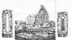
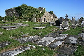
Tomfinlough is a civil parish in County Clare, Ireland. A Christian establishment was first made here around 540 AD. The parish lands were often raided by Irish, Viking, Norman and English forces in the years that followed. The church was allowed to fall into ruins during the period when the Catholic Church was penalized in Ireland.
Kilmacrehy, sometimes also Kilmacreehy, is a civil parish in County Clare, Ireland. The ruins of the old parish church lie near the coastal village of Liscannor, which is also a part of the parish.

Clonlea or Clonleigh is a civil parish in County Clare, Ireland. The main settlement is the village of Kilkishen. It is part of the Catholic parish of O'Callaghans Mills.

Rath is a civil parish in the barony of Inchiquin in County Clare, Ireland.
Kilnoe is a civil parish in County Clare, Ireland. It is a rural area, part of the Roman Catholic parish of Bodyke.

Kilfarboy is a civil parish on the Atlantic coast of County Clare in Ireland. The largest population centre in the parish is Milltown Malbay. It is also an ecclesiastical parish in the Roman Catholic Diocese of Killaloe. .

Crusheen, formerly called Inchicronan, is a Catholic parish in County Clare, Ireland. Inchicronan is also a civil parish, covering the same area. The parish lies to the northeast of Ennis. It contains the village of Crusheen and the ruin of Inchicronan Priory, built in 1190.
Killeely is a civil parish that lies partly in County Clare and partly in County Limerick in Ireland.
Clonrush or Clonmulsk is a civil parish in the barony of Leitrim in County Clare, Ireland. The largest settlement in the parish is Whitegate. In the Catholic Church, the parish is joined with Mountshannon.
Kilfintinan is a civil parish in County Clare, Ireland. It is part of the Catholic parish of Cratloe.

Killilagh or Killeilagh is a civil parish in County Clare, Ireland. It contains the village of Doolin.

Noughaval or Nohoval is a civil parish in County Clare, Ireland.

Killonaghan or Killonahan is a civil parish in County Clare, Ireland. It covers a part of the Burren, a rugged area on the Atlantic coast, and contains the seaside village of Fanore.