Related Research Articles
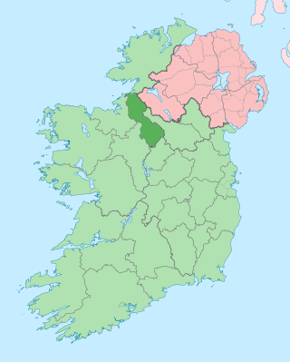
County Leitrim is a county in Ireland. It is in the province of Connacht and is part of the Northern and Western Region. It is named after the village of Leitrim. Leitrim County Council is the local authority for the county, which had a population of 35,087 according to the 2022 census.

The Western Way is a long-distance trail in Ireland. It is 179 kilometres long and begins in Oughterard, County Galway and ends in Ballycastle, County Mayo. It is typically completed in seven days. It is designated as a National Waymarked Trail by the National Trails Office of the Irish Sports Council and is managed by Coillte, Galway County Council, Mayo County Council, South Mayo Development Company and Mayo North & East Development Company.

Lough Gill is a freshwater lough (lake) mainly situated in County Sligo, but partly in County Leitrim, in Ireland. Lough Gill provides the setting for William Butler Yeats' poem "The Lake Isle of Innisfree".
Monasteraden is a village in County Sligo, Ireland. The village is located on the shores of Lough Gara. St Aiden's church is the village's church. Other sites include Lough Gara Lodge, Slí na Croí's Roundhouse Ecolodge, Drury's pub and the general store.

Dowra is a village and townland in northwest County Cavan, Ireland. Located in a valley on Lough Allen, it is the first village on, and marks the most uppermost navigable point of, the River Shannon. On one side of its bridge is County Cavan; on the other is County Leitrim. The nucleus of the village is situated on the Cavan side. It is located on the junction of the R200 and R207 regional roads.

Athracht is the patron saint of the parish of Locha Techet and Tourlestrane, County Sligo, Ireland. She was a sister of Bishop Conal of Drumconnell. Her feast day is 11 August.

Blacklion is a border village in west County Cavan, Ireland. It is situated on the N16 national primary road, just across the border from the County Fermanagh village of Belcoo.
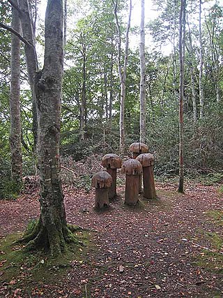
Hazelwood is an ancient area of woodland located just over 2 miles (3.2 km) outside the town of Sligo in northwest Ireland, in the parish of Calry. It is the setting for W.B.Yeats's The Song of Wandering Aengus. The wood is situated on the shores of Lough Gill, which contains Yeats's Lake Isle of Innisfree, and is popular for its scenic walks, which are dotted with sculptures. Swans, mallards and gulls congregate at the picnic area, and there is fishing on Lough Gill. The wood is part of the Hazelwood estate, owned by the Wynne family for two hundred years. The walk along forests trails provides views of the lake and Church Island, Cottage Island and Goat Island.

The Dartry Mountains are a mountain range in the north west of Ireland, in the north of counties Sligo and Leitrim. They lie between Lough Melvin, Lough Gill and Lough MacNean. The highest point is Truskmore at 647 metres (2,123 ft). Other notable mountains include Benbulbin at 526 metres (1,726 ft), Benwiskin at 514 metres (1,686 ft), and Tievebaun at 611 metres (2,005 ft).

Lough Gara is a lake in Counties Sligo and Roscommon, Ireland. It is an Important Bird Area protecting 1,788 ha of which most is covered by a Ramsar Site.

Lough Key Forest Park is an 800-hectare park on the southern shore of Lough Key, 40 km south east of Sligo Town and 3 km east of Boyle, County Roscommon, in the Republic of Ireland. Formerly part of the Rockingham Estate laid out by the King family, it is open to the public.

The Boyle River is a river in Ireland. Forming part of the Shannon River Basin, it flows from Lough Gara on the Sligo/Roscommon county border and thence through the town of Boyle to Lough Key. From there is continues eastwards through the village of Knockvicar to the River Shannon at Lough Drumharlow, near Carrick-on-Shannon. The length of the Boyle River is 64.4 km (40mi). The area of its basin is 725 km2.

Lough Talt is a lake in the Ox Mountains of south County Sligo, Ireland. The lake is located between the villages of Tubbercurry and Bonniconlon on the R294 road. Lough Talt is part of the Lough Hoe Bog Special Area of Conservation, an area of montane bogland and oligotrophic lakes.

The Miners' Way and Historical Trail is a long-distance trail in Ireland. It is a 118-kilometre (73-mile) long circular route that begins and ends in Arigna, County Roscommon. It is typically completed in five days. It is designated as a National Waymarked Trail by the National Trails Office of the Irish Sports Council and is managed by Roscommon Integrated Development Company, Roscommon County Council, Leitrim County Council and Sligo County Council. The trail was developed to encourage tourism in the area in the wake of the closure of the Arigna mines in 1990. The route was originally conceived by a local priest, Father Sean Tynan, and built with funding from the European Regional Development Fund. The trail was opened by broadcaster Donncha Ó Dúlaing in July 2000.

The Sligo Way is a long-distance trail mainly in County Sligo, Ireland. It is 78 kilometres long and begins in Larrigan, near Lough Talt and ends in Dromahair, County Leitrim. It is typically completed in three days. It is designated as a National Waymarked Trail by the National Trails Office of the Irish Sports Council and is managed by Sligo County Council, Sligo Integrated Development Company and the Sligo Walks Partnership.
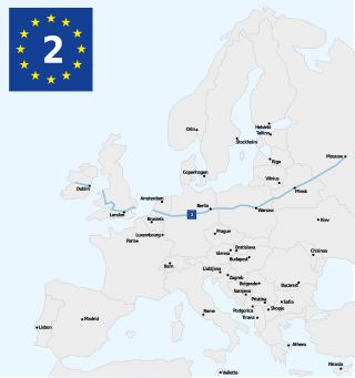
The Westmeath Way is a long-distance trail in County Westmeath, Ireland. It is 100 kilometres long and begins in Kilbeggan and ends in Athlone. It is typically completed in two days. It is designated as a National Waymarked Trail by the National Trails Office of the Irish Sports Council and is managed by Westmeath County Council and the Westmeath Way Committee. The trail forms part of the Dublin-Galway Greenway, part of the route 2 of the EuroVelo European cycle network.

The Beara-Breifne Way is a long-distance walking and cycling trail being developed from the Beara Peninsula in County Cork, Ireland, to Blacklion in the area of Breifne in County Cavan. The trail follows closely the line of the historical march of O’Sullivan Beare.
The Ireland Way is Ireland's longest coast-to-coast walking and cycling trail that joins the newly developed Beara-Breifne Way to the Ulster Way on the island of Ireland. The trail goes from the Beara Peninsula in County Cork, Republic of Ireland to Ballycastle, County Antrim in Northern Ireland. The Beara-Breifne Way trail follows closely the line of the historical march of O’Sullivan Beare. One of the first people to walk the Ireland Way in one go was a Canadian woman named Maysen Forbes in 2017.
Cashelmore, also called Clogher Stone Fort, is a stone ringfort (cashel) and National Monument located in County Sligo, Ireland.

The Owenmore River is a river in County Sligo, Ireland. Its source is in the far south of Sligo, near Gorteen and Lough Gara, from which it runs for 52.3 km to its juncture with the Unshin River near Collooney to form the Ballisodare River. Its catchment covers 655 square kilometres (253 sq mi), predominantly located in Sligo but with small parts in County Mayo and County Roscommon. The catchment is underlain by limestone, and the total length of all the rivers in the Greater Owenmore Basin Area is 639 kilometres (397 mi). There are approximately 1,470 hectares (5.7 sq mi) of lakes in the catchment, with Lough Arrow comprising most of this.
References
- 1 2 3 4 5 "Lung Lough Gara Way". Sport Ireland . Retrieved 4 December 2023.
- ↑ "Additional Funding for Walks in Sligo". Sligo Walks. 1 October 2021. Retrieved 4 December 2023.
| | This article related to the geography of County Roscommon, Ireland is a stub. You can help Wikipedia by expanding it. |
| | This article related to the geography of County Sligo, Ireland is a stub. You can help Wikipedia by expanding it. |