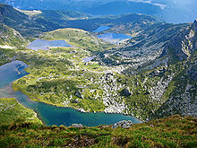
A paternoster lake is one of a series of glacial lakes connected by a single stream or a braided stream system. The name comes from the word Paternoster, another name for the Lord's Prayer derived from the Latin words for the prayer's opening words, "Our Father"; Paternoster lakes are so called because of their resemblance to rosary beads, with alternating prayer beads connected by a string or fine chain.[1]
Paternoster lakes occur in alpinevalleys, climbing one after the other to the valley's head, called a corrie, which often contains a cirque lake. Paternoster lakes are created by recessional moraines, or rock dams, that are formed by the advance and subsequent upstream retreat and melting of the ice.[1] The local variation in rock types can also be a factor in creating these lakes. A glacier encountering weaker rocks at its base, will be able to erode deeper than when it experiences harder, less erodible rocks. As the glacier melts, lakes form where weaker rock was excavated.
Excellent examples of this occur in California'sSierra Nevada, where many stream courses above 3000 m in elevation contain paternoster lakes.
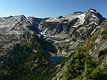
Glacier National park provides another example of paternoster lakes.[2] Five lakes in a row; Lake Sherburne, Swiftcurrent Lake, Lake Josephine, Grinnell Lake, and Upper Grinnell Lake all form a nice "rosary" that has produced some spectacular photographs.[3] The U shape of the valley confirms that it was formed by a glacier long ago, as opposed to a V-shaped valley cut by a river.
More good examples of paternoster lakes can be found in Waterton Lakes National Park, Canada. The three Carthew lakes are in a hanging cirque, reflecting their glacial origins, with Anderson Lake lower in elevation but still clearly part of this paternoster lake procession.
Another good example can be found in Yoho National Park, Canada. Lake OHara, Lake Oesa, and the large pools in the stream that connect the two give a total of five stair-stepped lakes/ponds. The presence of a rock glacier in the area points strongly to the glacial origins of this chain of lakes.
Notes
1 2 Christopherson, R. W., 2002, Geosystems (Fourth Edition): Upper Saddle River, New Jersey, Prentice Hall.
A glacier is a persistent body of dense ice that is constantly moving under its own weight. A glacier forms where the accumulation of snow exceeds its ablation over many years, often centuries. It acquires distinguishing features, such as crevasses and seracs, as it slowly flows and deforms under stresses induced by its weight. As it moves, it abrades rock and debris from its substrate to create landforms such as cirques, moraines, or fjords. Although a glacier may flow into a body of water, it forms only on land and is distinct from the much thinner sea ice and lake ice that form on the surface of bodies of water.
A valley is an elongated low area often running between hills or mountains, which will typically contain a river or stream running from one end to the other. Most valleys are formed by erosion of the land surface by rivers or streams over a very long period. Some valleys are formed through erosion by glacial ice. These glaciers may remain present in valleys in high mountains or polar areas.
Pater Noster, or the Lord's Prayer, is a prayer in Christianity.
Glacier National Park is an American national park located in northwestern Montana, on the Canada–United States border, adjacent to Waterton Lakes National Park in Canada—the two parks are known as the Waterton-Glacier International Peace Park. The park encompasses more than 1 million acres (4,000 km2) and includes parts of two mountain ranges, more than 130 named lakes, more than 1,000 different species of plants, and hundreds of species of animals. This vast pristine ecosystem is the centerpiece of what has been referred to as the "Crown of the Continent Ecosystem," a region of protected land encompassing 16,000 sq mi (41,000 km2).
Glaciology is the scientific study of glaciers, or, more generally, ice and natural phenomena that involve ice.
Landforms are categorized by characteristic physical attributes such as their creating process, shape, elevation, slope, orientation, rock exposure, and soil type.
The exposed geology of the Yosemite area includes primarily granitic rocks with some older metamorphic rock. The first rocks were laid down in Precambrian times, when the area around Yosemite National Park was on the edge of a very young North American continent. The sediment that formed the area first settled in the waters of a shallow sea, and compressive forces from a subduction zone in the mid-Paleozoic fused the seabed rocks and sediments, appending them to the continent. Heat generated from the subduction created island arcs of volcanoes that were also thrust into the area of the park. In time, the igneous and sedimentary rocks of the area were later heavily metamorphosed.
A tarn is a mountain lake, pond or pool, formed in a cirque excavated by a glacier. A moraine may form a natural dam below a tarn.
An arête is a narrow ridge of rock that separates two valleys. It is typically formed when two glaciers erode parallel U-shaped valleys. Arêtes can also form when two glacial cirques erode headwards towards one another, although frequently this results in a saddle-shaped pass, called a col. The edge is then sharpened by freeze-thaw weathering, and the slope on either side of the arête steepened through mass wasting events and the erosion of exposed, unstable rock. The word arête is actually French for "edge" or "ridge"; similar features in the Alps are often described with the German equivalent term Grat.
A pyramidal peak, sometimes called a glacial horn in extreme cases, is an angular, sharply pointed mountain peak which results from the cirque erosion due to multiple glaciers diverging from a central point. Pyramidal peaks are often examples of nunataks.
The geology of the Grand Teton area consists of some of the oldest rocks and one of the youngest mountain ranges in North America. The Teton Range, partly located in Grand Teton National Park, started to grow some 9 million years ago. An older feature, Jackson Hole, is a basin that sits aside the range.
A glacial erratic is a glacially deposited rock differing from the type of rock native to the area in which it rests. Erratics, which take their name from the Latin word errare, are carried by glacial ice, often over distances of hundreds of kilometres. Erratics can range in size from pebbles to large boulders such as Big Rock in Alberta.
Mount Timpanogos, often referred to as Timp, is the second-highest mountain in Utah's Wasatch Range. Timpanogos rises to an elevation of 11,752 ft (3,582 m) above sea level in the Uinta-Wasatch-Cache National Forest. With 5,270 ft (1,610 m) of topographic prominence, Timpanogos is the 47th-most prominent mountain in the contiguous United States.
A cirque is an amphitheatre-like valley formed by glacial erosion. Alternative names for this landform are corrie and cwm. A cirque may also be a similarly shaped landform arising from fluvial erosion.
Glacial landforms are landforms created by the action of glaciers. Most of today's glacial landforms were created by the movement of large ice sheets during the Quaternary glaciations. Some areas, like Fennoscandia and the southern Andes, have extensive occurrences of glacial landforms; other areas, such as the Sahara, display rare and very old fossil glacial landforms.
A terminal moraine, also called an end moraine, is a type of moraine that forms at the terminal (edge) of a glacier, marking its maximum advance. At this point, debris that has accumulated by plucking and abrasion, has been pushed by the front edge of the ice, is driven no further and instead is deposited in an unsorted pile of sediment. Because the glacier acts very much like a conveyor belt, the longer it stays in one place, the greater the amount of material that will be deposited. The moraine is left as the marking point of the terminal extent of the ice.
Rock glaciers are distinctive geomorphological landforms, consisting either of angular rock debris frozen in interstitial ice, former "true" glaciers overlain by a layer of talus, or something in-between. Rock glaciers are normally found at high latitudes and/or elevations, and may extend outward and downslope from talus cones, glaciers or terminal moraines of glaciers.
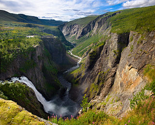
Overdeepening is a characteristic of basins and valleys eroded by glaciers. An overdeepened valley profile is often eroded to depths which are hundreds of metres below the lowest continuous surface line along a valley or watercourse. This phenomenon is observed under modern day glaciers, in salt-water fjords and fresh-water lakes remaining after glaciers melt, as well as in tunnel valleys which are partially or totally filled with sediment. When the channel produced by a glacier is filled with debris, the subsurface geomorphic structure is found to be erosionally cut into bedrock and subsequently filled by sediments. These overdeepened cuts into bedrock structures can reach a depth of several hundred metres below the valley floor.
The glacial series refers to a particular sequence of landforms in Central Europe that were formed during the Pleistocene glaciation beneath the ice sheets, along their margins and on their forelands during each glacial advance.
A valley step is a prominent change in the longitudinal slope of a valley, mainly in trough valleys formed by glaciers.
This page is based on this Wikipedia article Text is available under the CC BY-SA 4.0 license; additional terms may apply. Images, videos and audio are available under their respective licenses.