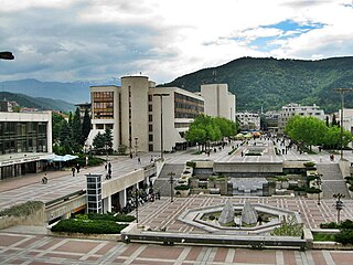
Blagoevgrad is а town in Southwestern Bulgaria, the administrative centre of Blagoevgrad Municipality and of Blagoevgrad Province. With a population of almost 70,000 inhabitants, it is the economic and cultural centre of Southwestern Bulgaria. It is located in the valley of the Struma River at the foot of the Rila Mountains, 101 kilometres south of Sofia, close to the border with North Macedonia.

Blagoevgrad Province, also known as Pirin Macedonia or Bulgarian Macedonia, is a province (oblast) of southwestern Bulgaria. It borders four other Bulgarian provinces to the north and east, the Greek region of Macedonia to the south, and North Macedonia to the west. The province has 14 municipalities with 12 towns. Its principal city is Blagoevgrad, while other significant towns include Bansko, Gotse Delchev, Melnik, Petrich, Razlog, Sandanski, and Simitli.

Rila is the highest mountain range of Bulgaria, the Balkan Peninsula, and Southeast Europe. It is situated in southwestern Bulgaria and forms part of the Rila–Rhodope Massif. The highest summit is Musala at an elevation of 2,925 m which makes Rila the sixth highest mountain range in Europe after the Caucasus, the Alps, Sierra Nevada, the Pyrenees and Mount Etna, and the highest one between the Alps and the Caucasus. It spans a territory of 2,629 km2 with an average elevation of 1487 m. The mountain is believed to have been named after the river of the same name, which comes from the Old Bulgarian verb "рыти" meaning "to grub".
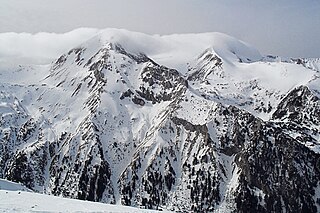
The Pirin Mountains are a mountain range in southwestern Bulgaria, with the highest peak, Vihren, at an altitude of 2,914 m (9,560 ft).

The Monastery of Saint John of Rila, also known as Rila Monastery ("Sveti Ivan Rilski", is the largest and most famous Eastern Orthodox monastery in Bulgaria. It is situated in the southwestern Rila Mountains, 117 km south of the capital Sofia in the deep valley of the Rilska River at an elevation of 1,147 m above sea level, inside of Rila Monastery Nature Park. The monastery is named after its founder, the hermit Saint Ivan of Rila, and houses approximately 60 monks. The monastery is a popular pilgrimage site for many Orthodox Christians.
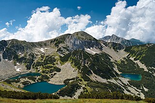
Pirin National Park, originally named Vihren National Park, encompasses the larger part of the Pirin Mountains in southwestern Bulgaria, spanning an area of 403.56 square kilometers (155.82 sq mi).

The Iskar is a right tributary of the Danube. With a length of 368 km, it is the longest river that runs entirely within Bulgaria. Originating as three forks in Balkan's highest mountain range Rila, the Iskar flows in a northern direction until its confluence with the Danube. As it flows northwards it fuels the largest artificial lake in the country, the Iskar Reservoir, forms the divide between the Vitosha and Plana Mountains in the west and the Sredna Gora mountain range in the east before entering the Sofia Valley, which contains the nation's capital Sofia. From there the Iskar runs through the Balkan Mountains, forming the spectacular 84 km long Iskar Gorge. As it crosses the mountains, its water course turns in a north-eastern direction at Lakatnik. North of the Balkan Mountains, the river crosses the Danubian Plain and finally flows into the Danube between the villages of Baykal and Gigen. Geologically, Iskar is the oldest river in the Balkan Peninsula.

Lake Asveja or Dubingiai Lake is the longest lake in Lithuania. It covers 9.78 km2 area and reaches a depth of 50.2m which makes it the third deepest lake in Lithuania. It lies partly in Molėtai district, Švenčionys district and Vilnius district. The alternative name comes from the historical Dubingiai Castle, constructed on the former island, and the small town of Dubingiai situated on the lake. The town is a popular tourist destination. Žeimena River flows south of the lake and people rent boats or kayaks to go down the river to the Neris River.
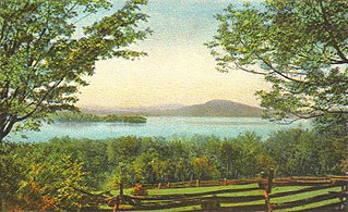
Rangeley Lake, located in Franklin County, Maine, United States, is fed by several streams. Its waters flow out from the lake's northwestern corner via the short Rangeley River into Mooselookmeguntic Lake, then Upper and Lower Richardson Lakes, Umbagog Lake and ultimately into the Androscoggin River, Merrymeeting Bay, the lower Kennebec River, the Gulf of Maine and the Atlantic Ocean.

The Popovo Lake is a glacial lake situated in the northern section of the Pirin mountain range, south-western Bulgaria. It is one of the eleven Popovi Lakes. The lake and its surroundings are among the most popular places for summer tourism in Pirin National Park. It is situated at the bottom of the Popovski cirque and is surrounded by the peaks Sivria (2,591 m), Dzhano (2,668 m), Kralev Dvor (2,680 m), Momin Dvor (2,723 m) and Dzhengal (2,730 m).

Naukuchiatal or "lake of nine corners" is a small hill station, near Nainital Town in Nainital district of Kumaon, Uttarakhand, India. The chairman is Devendra Singh chanotiya.
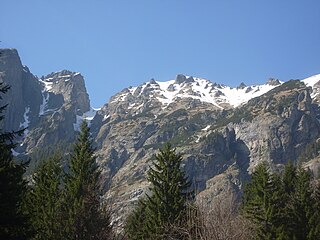
Rila Monastery Nature Park is one of the largest nature parks in Bulgaria, spanning a territory of 252.535 km2 (97.504 sq mi) in the western part of the Rila mountain range at an altitude between 750 and 2,713 metres. It is in Rila Municipality, Kyustendil Province and includes forests, mountain meadows, alpine areas, and 28 glacial lakes. With a little more than 1 million visitors, it is the second-most visited nature park in the country, after Vitosha Nature Park.

The Urdini Lakes are a group of glacial lakes, situated in the northwestern Rila Mountains in Bulgaria.

The Malyovishki Lakes are a group of three glacial lakes, situated in the northwestern Rila Mountains in Bulgaria. They are located to the north of the summit of Malyovitsa (2,729 m) in the southwestern part of the homonymous cirque in the upper reaches of the Malyovitsa River, a right tributary of the Cherni Iskar, which is considered the main stem of Bulgaria's longest river that runs entirely within the country, the Iskar. They are terraced from the southwest to the northeast along 300 m.

The Chanakgyolski Lakes are a group of two glacial lakes, situated in the northwestern Rila Mountains in Bulgaria, in close proximity to the Seven Rila Lakes.

The Smradlivo Lake is a glacial lake located in the central section of the Rila mountain range, south-western Bulgaria. It is the second of the five Smradlivi Lakes and is situated at an altitude of 2,298 m in a hanging valley facing the valley of the Rilska River to the north between the summits of Rilets (2,713 m) to the south-west and Kyoravitsa (2,612 m) to the south. It falls within the boundaries of the Rila Monastery Nature Park.

Musala Lakes are a group of seven glacial lakes situated in the Rila mountain range of southwestern Bulgaria at an altitude between 2,322 m and 2,709 m.

The Dzherman is a river in south-western Bulgaria, a left tributary of the Struma, flowing through the municipalities of Sapareva Banya, Dupnitsa and Boboshevo in Kyustendil Province. The river is 47.8 km long and drains the northwestern sections of the Rila mountain range.

Malokamenishki Lakes, also known as Belemetski Lakes, are a group of 34 glacial lakes situated southwest of the main ridge of Pirin mountain range in Bulgaria. They are the source area of the river Mozgovitsa, one of the tributaries of the Sandanska Bistritsa of the Struma river basin. The lake group is located in the Belemeto cirque, flanked by the main mountain ridge and the secondary ridges of Kamenitsa and Mozgovitsa, crowned by the summits of Kamenitsa Peak (2,822 m), Kralev Dvor (2,680 m), Momin Dvor (2,723 m) and Valyavishki Chukar (2,664 m).

Ribni Lakes are a group of two larger and several smaller non-permanent glacial lakes situated in the central part of the Rila mountain range in southwestern Bulgaria. They are located in a deep cirque widely opened to the north between the summits of Kyoravitsa (2,612 m) to the west, Kanarata (2,667 m) to the south and Yosifitsa (2,697 m) to the northeast. They are located in the eastern reaches of the Rila Monastery Nature Park.


