
Allihies is a townland in the civil parish of Kilnamanagh, in County Cork, Ireland. The townland of Allihies is located at the western tip of the Beara Peninsula.

Castletownbere is a town in County Cork in Ireland. It is located on the Beara Peninsula by Berehaven Harbour. It is also known as Castletown Berehaven.
In these lists of mountains in Ireland, those within Northern Ireland, or on the Republic of Ireland – United Kingdom border, are marked with an asterisk, while the rest are within the Republic of Ireland. Where mountains are ranked by height, the definition of the topographical prominence used to classify the mountain, is noted. In British definitions, a height of 600 metres (1,969 ft) is required for a mountain, whereas in Ireland, a lower threshold of 500 metres (1,640 ft) is sometimes advocated.

Beara or the Beara Peninsula is a peninsula on the south-west coast of Ireland, bounded between the Kenmare "river" to the north side and Bantry Bay to the south. It contains two mountain ranges running down its centre: the Caha Mountains and the Slieve Miskish Mountains. The northern part of the peninsula from Kenmare to near Ardgroom is in County Kerry, while the rest forms the barony of Bear in County Cork.
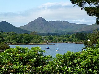
Sugarloaf Mountain is one of the Caha Mountains, south-west of Glengarriff in County Cork, Ireland. It is a pointed mountain with a height of 574 metres (1,883 ft).

Adrigole is a village on the Beara Peninsula in County Cork, Ireland. It is centred on the junction of the R572 and R574 regional roads. The electoral division in which the village sits has a sparsely distributed population of about 450 people.

Knockmealdown is the highest peak of the Knockmealdown Range of mountains, located on the border between Co Tipperary and Co Waterford.

Hungry Hill is a novel by British author Daphne du Maurier, published in 1943. It was her seventh novel. There have been 33 editions of the book printed.

Cnoc na Péiste, anglicised Knocknapeasta, at 988 metres (3,241 ft), is the fourth-highest peak in Ireland, on the Arderin and Vandeleur-Lynam lists. Cnoc na Péiste is part of the MacGillycuddy's Reeks range in County Kerry. It is one of only two 3,000 ft peaks in the Reeks with a prominence above the Marilyn threshold of 150 metres, and is the highest summit of the Eastern Reeks. In 1943, a USAAF plane crashed into the mountain, killing all five crew, and parts of the wreckage can still be seen in Lough Cummeenapeasta.

Maumtrasna, historically Formnamore, is the highest of the Partry Mountains in south County Mayo, Ireland, rising to 682 metres (2,238 ft) above sea level. The summit is broad and flat with several ridges running off it, including Skeltia, Benwee, Buckaun and Binnaw. The peak of Knocklaur stands on the ridge between Maumtrasna and Devilsmother mountains.
Musheramore is a mountain with a height of 643 metres (2,110 ft) in County Cork, Ireland. It is the highest of the Boggeragh Mountains. The neighbouring hill is Musherabeg, with a height of 499 metres (1,637 ft). Historically the mountain was called Knock Muskery, from Cnoc Múscraighe meaning "hill of the Múscraige", a Gaelic tribe who gave their name to the barony of Muskerry. There are two holy wells on the mountain: one near the summit for sick animals, and one on its northern slopes for humans, where mass was traditionally held on midsummer.

Knocknadobar at 690 metres (2,260 ft), is the 102nd–highest peak in Ireland on the Arderin scale, and the 123rd–highest peak in Ireland according to the Vandeleur-Lynam scale. Knocknadobar is one of the main mountains of the Iveragh Peninsula in County Kerry, Ireland, and has been one of the most important sites of pilgrimage in Ireland since medieval times.
The Big Gun, at 939 metres (3,081 ft) high, is the ninth-highest peak in Ireland on the Arderin list, or the tenth-highest according to the Vandeleur-Lynam list. It is part of the MacGillycuddy's Reeks in County Kerry, and is also known as Lackagarrin or Foilnabreachaun.

Caher West Top at 973.4 metres, is the fifth-highest peak in Ireland on the Irish Vandeleur-Lynam classification, and part of the MacGillycuddy's Reeks range. Caher West Top is the only Furth to have a prominence below 30 metres (98 ft).

Maolán Buí, also known by the name Bearna Rua, at 973 metres (3,192 ft) high, is the fifth-highest peak in Ireland on the Arderin list, or the sixth-highest peak in Ireland according to the Vandeleur-Lynam list. Maolán Buí is also known for its narrow north-west spur, called The Bone. It is part of the MacGillycuddy's Reeks in Kerry.

The Bones, at 957 metres (3,140 ft) high, is the seventh-highest peak in Ireland on the Arderin list, or the eighth-highest according to the Vandeleur-Lynam list. It is part of the MacGillycuddy's Reeks in County Kerry, and is a small sharp peak on the dramatic Beenkeragh Ridge, and is sometimes mistaken with The Bone, the north-east spur of Maolán Buí, which descends into the Hag's Glen.

Cnoc an Chuillinn, at 958 metres (3,143 ft), is the sixth-highest peak in Ireland on the Arderin list and the seventh-highest peak in Ireland on the Vandeleur-Lynam list. The name is sometimes incorrectly anglicised to Knockacullion, which is a name used for peaks and townlands in other parts of Ireland. Cnoc an Chuillinn is part of the MacGillycuddy's Reeks range in County Kerry.

Cruach Mhór, at 932 metres (3,058 ft) high, is the tenth-highest peak in Ireland on the Arderin list, and the eleventh-highest peak in Ireland according to the Vandeleur-Lynam list. A distinctive square grotto marks the summit. It is part of the MacGillycuddy's Reeks in County Kerry.

Brassel Mountain at 575 metres (1,886 ft), is the 261-st highest peak in Ireland, on the Arderin scale. It is part of the MacGillycuddy's Reeks range in County Kerry. Brassel Mountain is the south-east spur of the larger neighbouring peaks, Cnoc an Chuillinn 958 metres (3,143 ft), and Cnoc an Chuillinn East Top 926 metres (3,038 ft). Because of its positioning away from the main ridge of the Reeks, and away from the glens used to access the Reeks, Brassel is less frequently climbed, but can be used as an exit, or entry point to the main ridge.

Cnoc na Toinne, at 845 metres (2,772 ft), is the 17th-highest peak in Ireland on the Arderin list, and the 23rd-highest peak in Ireland on the Vandeleur-Lynam list. It is part of the MacGillycuddy's Reeks range in County Kerry. Cnoc na Toinne lies between the Coomloughra Reeks and the Eastern Reeks, and is just above the col of the Devil's Ladder, a popular route for climbing Carrauntoohil, Ireland's highest mountain.


