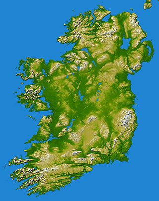
In these lists of mountains in Ireland, those within Northern Ireland, or on the Republic of Ireland – United Kingdom border, are marked with an asterisk, while the rest are within the Republic of Ireland. Where mountains are ranked by height, the definition of the topographical prominence used to classify the mountain, is noted. In British definitions, a height of 600 metres (1,969 ft) is required for a mountain, whereas in Ireland, a lower threshold of 500 metres (1,640 ft) is sometimes advocated.

Lugnaquilla is the highest of the Wicklow Mountains in Ireland, rising to 925 metres (3,035 ft). It is also the highest Irish mountain outside of County Kerry, and the highest point in County Wicklow and the province of Leinster. Lugnaquilla overlooks the Glen of Imaal to the west and Glenmalure to the east.

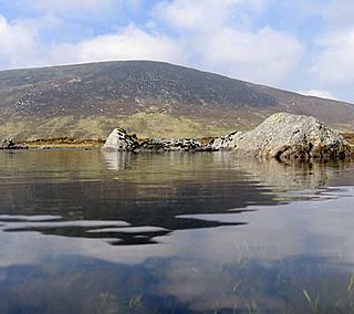
Mweelrea is a mountain on the Atlantic coast of County Mayo, Ireland. Rising to 814 metres (2,671 ft), it is the highest mountain in the western province of Connacht, and is noted for its southeastern cliff-lined corries, and its views. Mweelrea overlooks Killary Harbour and is at the heart of a "horseshoe-shaped" massif that includes the peaks of Ben Lugmore and Ben Bury. The massif is called the Mweelrea Mountains or the Mweelrea Range.

Tonelagee, is at 817 metres (2,680 ft), is the 25th–highest peak in Ireland on the Arderin scale, and the 33rd–highest peak on the Vandeleur-Lynam scale. Tonelagee is situated in the central sector of the Wicklow Mountains range, and sits on the main "central spine" of the range that runs from Kippure in the north, to Lugnaquillia in the south; and in particular, the continuous "central boggy ridge" that runs from the Sally Gap in the north, via Mullaghcleevaun, to Tonelagee. Tonelagee is the third highest peak in Wicklow after Lugnaquilla and Mullaghcleevaun.
Slieve Mish Mountains, is a predominantly sandstone mountain range at the eastern end of the Dingle Peninsula in County Kerry, Ireland. Stretching 19 kilometres, from the first major peak of Barnanageehy outside of Tralee in the east, to Cnoc na Stuaice in near Central Dingle in the west, the range has over 17 material peaks, with the core of the mountain range based around the massif of its highest peak, Baurtregaum, and its deep glacial valleys of Derrymore Glen and Curraheen Glen.
Cloghernagh at 800 metres (2,600 ft), does not have the prominence to qualify as an Arderin, but does have the prominence to be the 40th–highest peak on the Vandeleur-Lynam scale. Cloghernagh is situated in the southern sector of the Wicklow Mountains range, and is part of the large massif of Lugnaquilla 925 metres (3,035 ft), Wicklow's highest mountain.

Slievemaan at 759 metres (2,490 ft), is the 54th–highest peak in Ireland on the Arderin scale, and the 70th–highest peak on the Vandeleur-Lynam scale. Slievemaan is situated in the southwen sector of the Wicklow Mountains range, and is part of the large massif of Lugnaquilla 925 metres (3,035 ft), Wicklow's highest mountain. Slievemaan lies at the southern end of the Glen of Imaal.

Camenabologue at 758 metres (2,487 ft), is the 55th–highest peak in Ireland on the Arderin scale, and the 71st–highest peak on the Vandeleur-Lynam scale. Camenabologue is situated in the southern section of the Wicklow Mountains, and has a subsidiary summit, Camenabologue SE Top 663 metres (2,175 ft). Camenabologue forms a horseshoe on a "boggy" massif, at the head of Glenmalure, with its neighbours, that include Table Mountain 702 metres (2,303 ft), and Conavalla 734 metres (2,408 ft). Camenabologue also sits on the main "central spine" of the Wicklow mountains and links to the larger massif of Lugnaquilla 925 metres (3,035 ft), which lies at the southern terminus of the whole range.

Baurtregaum at 851 metres (2,792 ft), is the 13th–highest peak in Ireland on the Arderin scale, and the 18th–highest peak on the Vandeleur-Lynam scale. Baurtregaum is situated at the centre of the massif of the Slieve Mish Mountains on the Dingle Peninsula in County Kerry, Ireland. It is the tallest mountain of the Slieve Mish range, with a number of major subsidiary summits.

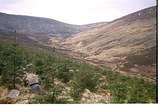
Keadeen Mountain at 653 metres (2,142 ft), is the 152nd–highest peak in Ireland on the Arderin scale, and the 184th–highest peak on the Vandeleur-Lynam scale. Keadeen is situated at the far southwestern end of the Wicklow Mountains range, separated from the large massif of Lugnaquilla on its own small isolated massif with Carrig Mountain 571 metres (1,873 ft); it overlooks the Glen of Imaal from the south.
Corrigasleggaun at 794 metres (2,605 ft), is the 35th–highest peak in Ireland on the Arderin scale, and the 45th–highest peak on the Vandeleur-Lynam scale. Corrigasleggaun is situated in the southwestern sector of the Wicklow Mountains range, and is part of the large massif of Lugnaquilla 925 metres (3,035 ft), Wicklow's highest mountain. Corrigasleggaun lies at the head of the glen of the easterly flowing Carrawaystick River, which includes the scenic corrie lake of Kelly's Lough near its summit, and Carrawaystick Mountain at its base. Corrigasleggaun also lies alongside Lugnaquilla's South Prison, from which the River Ow flows south to the Aghavannagh Bridge.

Gravale at 718 metres (2,356 ft), is the 79th–highest peak in Ireland on the Arderin scale, and the 98th–highest peak on the Vandeleur-Lynam scale. Gravale is in the middle sector of the Wicklow Mountains range, in Wicklow, Ireland. Gravale sits on a north-east to south-west "boggy ridge" that forms the "central spine" of the whole range, which runs from the Sally Gap, to Carrigvore 682 metres (2,238 ft), to Gravale, and after a col to Duff Hill 720 metres (2,360 ft), which is part of the larger massif of Mullaghcleevaun 849 metres (2,785 ft).

Moanbane at 703 metres (2,306 ft), is the 85th–highest peak in Ireland on the Arderin scale, and the 106th–highest peak on the Vandeleur-Lynam scale. Moanbane is in the central sector, at the western edge, of the Wicklow Mountains, in Wicklow, Ireland. Moanbane is on a small massif alongside Silsean 698 metres (2,290 ft) which lies between the Blessington lakes, and the taller mountain of Mullaghcleevaun 849 metres (2,785 ft).
Silsean at 698 metres (2,290 ft), is the 92nd–highest peak in Ireland on the Arderin scale, and the 114th–highest peak on the Vandeleur-Lynam scale. Silsean is in the central sector, at the western edge, of the Wicklow Mountains, in Wicklow, Ireland. Silsean is on a small massif alongside Moanbane 703 metres (2,306 ft) which lies between the Blessington lakes, and the major massif of Mullaghcleevaun 849 metres (2,785 ft).
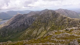
Bencollaghduff at 696 metres (2,283 ft), is the 93rd–highest peak in Ireland on the Arderin scale, and the 115th–highest peak on the Vandeleur-Lynam scale. Bencollaghduff is situated near the centre of the core massif of the Twelve Bens mountain range in the Connemara National Park in County Galway, Ireland. It is the 3rd tallest mountain of the Twelve Bens range, after Benbaun 729 metres (2,392 ft), to which it is connected by the northern col of Maumina; and after Bencorr 711 metres (2,333 ft), to which it is connected by a high southeast rocky ridge.

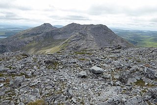
Cnoc na Toinne, at 845 metres (2,772 ft), is the 17th-highest peak in Ireland on the Arderin list, and the 23rd-highest peak in Ireland on the Vandeleur-Lynam list. It is part of the MacGillycuddy's Reeks range in County Kerry. Cnoc na Toinne lies between the Coomloughra Reeks and the Eastern Reeks, and is just above the col of the Devil's Ladder, a popular route for climbing Carrauntoohil, Ireland's highest mountain.

Tonduff at 642 metres (2,106 ft), is the 169th–highest peak in Ireland on the Arderin scale, and the 202nd–highest peak on the Vandeleur-Lynam scale. Tonduff is in the far northeastern section of the Wicklow Mountains, in Wicklow, Ireland. The main flat summit is sometimes listed as Tonduff North, while the subsidiary summit, Tonduff East Top 593 metres (1,946 ft), is sometimes listed as Tonduff South. Tonduff East Top has a prominence of only 15 metres (49 ft), which just qualifies it as an Arderin Beg. A bog on the western slopes of Tonduff, the Liffey Head Bog, forms the source of the River Liffey; bogs on the southern slopes of Tonduff, forms the source of the River Dargle.
Benbreen at 691 metres (2,267 ft), is the 100th–highest peak in Ireland on the Arderin scale, and the 122nd–highest peak on the Vandeleur-Lynam scale. Benbreen lies in the southern end of the Twelve Bens mountain range in the Connemara National Park in County Galway, Ireland. Benbreen is the 4th-tallest mountain of the Twelve Bens range, after Benbaun 729 metres (2,392 ft), Bencorr 711 metres (2,333 ft), and Bencollaghduff 696 metres (2,283 ft). Benbreen's profile is of a "high narrow rocky ridge with several summits", than a typical "peaked mountain".

Bengower at 664 metres (2,178 ft), is the 135th–highest peak in Ireland on the Arderin scale, and the 166th–highest peak on the Vandeleur-Lynam scale. Bengower is in the southern end of the Twelve Bens mountain range in the Connemara National Park in County Galway, Ireland, and is the 6th-tallest of the core Twelve Bens.

Benglenisky at 516 metres (1,693 ft), is the 368th–highest peak in Ireland on the Arderin scale. Benglenisky is the second most southern peak, after neighbouring Benlettery, of the Twelve Bens mountain range in the Connemara National Park in County Galway, Ireland, and is the lowest of the core Twelve Bens.