MacGillycuddy's Reeks is a sandstone and siltstone mountain range in the Iveragh Peninsula in County Kerry, Ireland. Stretching 19 kilometres, from the Gap of Dunloe in the east, to Glencar in the west, the Reeks is Ireland's highest mountain range, and includes most of the highest peaks and sharpest ridges in Ireland, and the only peaks on the island over 1,000 metres in height.

Turlough Hill, also known as Tomaneena, is a 681-metre-high (2,234 ft) mountain in County Wicklow in Ireland and site of Ireland's only pumped-storage hydroelectricity plant. The power station is owned and operated by the ESB and can generate up to 292 megawatts (392,000 hp) of electricity at times of peak demand.

Mount Brandon or Brandon, at 952 metres (3,123 ft), is one of the ten highest peaks in Ireland, being the 8th–highest peak in Ireland on the Arderin list, and the 9th–highest on the Vandeleur-Lynam list. Brandon is the highest Irish mountain outside the MacGillycuddy's Reeks range and has the greatest prominence of any Irish peak except Carrauntoohil, Ireland's highest mountain.

Lugnaquilla, at 925 metres (3,035 ft), is the 11th–highest peak in Ireland on the Arderin list, and 13th–highest on the Vandeleur-Lynam list, and the highest Irish mountain outside of Kerry. Lugnaquilla is the highest point in Wicklow, and in the province of Leinster. Lugnaquilla is in the Wicklow Mountains, and overlooks the Glen of Imaal to the west and Glenmalure to the east.

Mweelrea at 814 metres (2,671 ft), is the 26th-highest peak in Ireland on the Arderin scale, and the 34th-highest peak on the Vandeleur-Lynam scale. Mweelrea is situated near the apex of a "horseshoe-shaped" massif that includes the peaks of Ben Lugmore and Ben Bury, and which is located between Killary Harbour and Doo Lough, in Mayo, Ireland. Mweelrea is the provincial top for Connacht, and is noted for its southeastern cliff lined corries, and its views. The massif is called the Mweelrea Mountains or the Mweelrea Range.

Galtymore or Galteemore is a mountain in the province of Munster, Ireland. At 917.9 metres, it is one of Ireland's highest mountains, being the 12th-highest on the Arderin list, and 14th-highest on the Vandeleur-Lynam list. Galtymore has the 4th-highest topographic prominence of any peak in Ireland, which classifies Galtymore as a P600, or "major mountain". It is one of the 13 Irish Munros.

Mullaghcleevaun at 849 metres (2,785 ft), is the 15th–highest peak in Ireland on the Arderin scale, and the 20th–highest peak on the Vandeleur-Lynam scale. Mullaghcleevaun is in the central sector of the Wicklow Mountains range, in Wicklow, Ireland; it is the 2nd highest peak in Wicklow after Lugnaquilla. Mullaghcleevaun lies on the main "central spine" of the whole range that runs from Kippure in the north, to Lugnaquillia in the south; and in particular, it lies on the continuous "central boggy ridge" that runs from the Sally Gap to Tonelagee.

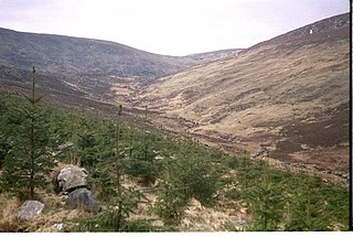
Camaderry at 699 metres (2,293 ft), is the 90th-highest peak in Ireland on the Arderin scale, and the 112th-highest peak on the Vandeleur-Lynam scale. Camaderry is situated in the southern sector of the Wicklow Mountains range, and forms a broad horseshoe around the valley of Glendalough with the hydroelectric station at Turlough Hill 681 metres (2,234 ft), and the mountains of Conavalla 734 metres (2,408 ft), and Lugduff 652 metres (2,139 ft). Camaderry has a subsidiary summit, Camaderry South East Top 677 metres (2,221 ft), and both lie across the deep Wicklow Gap from Tonelagee 817 metres (2,680 ft), which sits on the "central spine" of the Wicklow range.

Mangerton or Mangerton Mountain, at 838 metres (2,749 ft), is the 19th-highest peak in Ireland on the Arderin list, and the 26th–highest mountain according to the Vandeleur-Lynam list. Mangerton is the tallest mountain in the Mangerton Mountain Group, also called the Mangerton Mountains or the Mountains of East Kerry, a range that includes five other major mountains that have a height above 2,000 feet (610 m). Mangerton's western slopes lie within the Killarney National Park. On Mangerton's north-western face lies a deep corrie lake called the Devil's Punchbowl, which is a popular scenic destination for hill walkers; although the mountain is often overlooked by walkers due to the proximity of its more scenic and accessible neighbour, Torc Mountain. The far northern slopes of Mangerton was the site of an important 13th-century battle between the Mac Cárthaigh, and the FitzGeralds, known as the "Tooreencormick battle site".

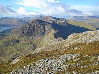
Cnoc na Péiste, anglicised Knocknapeasta, at 988 metres (3,241 ft), is the fourth-highest peak in Ireland, on the Arderin and Vandeleur-Lynam lists. Cnoc na Péiste is part of the MacGillycuddy's Reeks range in County Kerry. It is one of only two 3,000 ft peaks in the Reeks with a prominence above the Marilyn threshold of 150 metres, and is the highest summit of the Eastern Reeks. In 1943, a USAAF plane crashed into the mountain, killing all five crew, and parts of the wreckage can still be seen in Lough Cummeenapeasta.

Binn idir an Dá Log, sometimes anglicized Benadolug, at 702 metres (2,303 ft), is the highest of the Maumturk Mountains in Connemara in County Galway, Ireland. It is at the middle of the long north-west to south-east central spine of the range. The summit is the 87th-highest peak in Ireland on the Arderin list, and the 108th-highest on the Vandeleur-Lynam list.

Beenkeragh or Benkeeragh is the second-highest peak in Ireland, at 1,008.2 metres (3,308 ft), on both the Arderin and Vandeleur-Lynam lists. It is part of the MacGillycuddy's Reeks range in County Kerry. Beenkeragh also gives its name the infamous Beenkeragh Ridge, the narrow rocky arete between Beenkeragh and Carrauntoohil, Ireland's highest mountain.
Corrigasleggaun at 794 metres (2,605 ft), is the 35th–highest peak in Ireland on the Arderin scale, and the 45th–highest peak on the Vandeleur-Lynam scale. Corrigasleggaun is situated in the southwestern sector of the Wicklow Mountains range, and is part of the large massif of Lugnaquilla 925 metres (3,035 ft), Wicklow's highest mountain. Corrigasleggaun lies at the head of the glen of the easterly flowing Carrawaystick River, which includes the scenic corrie lake of Kelly's Lough near its summit, and Carrawaystick Mountain at its base. Corrigasleggaun also lies alongside Lugnaquilla's South Prison, from which the River Ow flows south to the Aghavannagh Bridge.

Caher or Caher East Top at 1,000 metres (3,300 ft), is the third-highest peak in Ireland, on the Irish Arderin and Vandeleur-Lynam classifications. It is part of the MacGillycuddy's Reeks in County Kerry.

The Bones, at 957 metres (3,140 ft) high, is the seventh-highest peak in Ireland on the Arderin list, or the eighth-highest according to the Vandeleur-Lynam list. It is part of the MacGillycuddy's Reeks in County Kerry, and is a small sharp peak on the dramatic Beenkeragh Ridge, and is sometimes mistaken with The Bone, the north-east spur of Maolán Buí, which descends into the Hag's Glen.

Cnoc an Chuillinn, at 958 metres (3,143 ft), is the sixth-highest peak in Ireland on the Arderin list and the seventh-highest peak in Ireland on the Vandeleur-Lynam list. The name is sometimes incorrectly anglicised to Knockacullion, which is a name used for peaks and townlands in other parts of Ireland. Cnoc an Chuillinn is part of the MacGillycuddy's Reeks range in County Kerry.

Cruach Mhór, at 932 metres (3,058 ft) high, is the tenth-highest peak in Ireland on the Arderin list, and the eleventh-highest peak in Ireland according to the Vandeleur-Lynam list. A distinctive square grotto marks the summit. It is part of the MacGillycuddy's Reeks in County Kerry.

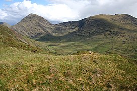
Mullaghanattin is a summit of the Dunkerron Mountains, part of the Mountains of the Iveragh Peninsula in County Kerry, Ireland.

Broaghnabinnia is a summit of the Dunkerron Mountains, part of the Mountains of the Iveragh Peninsula in County Kerry, Ireland.
Knocknahillion is one of the Maumturk Mountains of Connemara in County Galway, Ireland. At 607 metres (1,991 ft), it is the 210th–highest peak in Ireland on the Arderin list, and 256th–highest on the Vandeleur-Lynam list. Knocknahillion is in the middle sector of the long north-west to south-east spine of the Maumturks. The summit is offset to the west of the rocky central ridge of the Maumturks, and its western-facing slopes have a distinctive "diagonal" rock stratification when viewed from the Inagh Valley.