
A Munro is defined as a mountain in Scotland with a height over 3,000 feet (914.4 m), and which is on the Scottish Mountaineering Club (SMC) official list of Munros; there is no explicit topographical prominence requirement. The best known Munro is Ben Nevis, the highest mountain in the British Isles at 4,411 ft.

The Cuillin is a range of mostly jagged rocky mountains on the Isle of Skye in Scotland. The main Cuillin ridge is also called the Black Cuillin to distinguish it from the Red Cuillin, which lie to the east of Glen Sligachan.

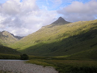
Knoydart is a peninsula in Lochaber, Highland, on the west coast of Scotland. Knoydart is sandwiched between Lochs Nevis and Hourn — often translated as "Loch Heaven" and "Loch Hell" respectively, although the somewhat poetic nature of these derivations is disputed. Forming the northern part of what is traditionally known as na Garbh-Chrìochan or "the Rough Bounds", because of its harsh terrain and remoteness, Knoydart is also referred to as "Britain's last wilderness". It is only accessible by boat, or by a 16-mile (26 km) walk through rough country, and the seven miles (11 km) of tarred road are not connected to the UK road system.

Ben Lomond, 974 metres (3,196 ft), is a mountain in the Scottish Highlands. Situated on the eastern shore of Loch Lomond, it is the most southerly of the Munros. Ben Lomond lies within the Ben Lomond National Memorial Park and the Loch Lomond and The Trossachs National Park, property of the National Trust for Scotland.

Blà Bheinn or Blàbheinn, also known as Blaven, is a mountain on the Isle of Skye in Scotland. It is usually regarded as an outlier of the Black Cuillin range. It is a Munro with a height of 929 metres (3,048 ft). North of the summit is the ridge of Clach Glas, which leads to the peaks of Garbh-bheinn and Sgùrr nan Each. It is mainly composed of gabbro, a rock with excellent grip for mountaineers and scramblers.
Sgùrr na Cìche is a mountain in Knoydart, in the Northwest Highlands of Scotland. It lies on the edge of Knoydart in an area known as the Rough Bounds of Knoydart.

Gaor Bheinn, also known in English as Gulvain, is a mountain in the Northwest Highlands of Scotland. It is in Lochaber, south of Loch Arkaig and north of the road west of Fort William. It is composed of banded granite and shaped like a letter Y, with two tops connected by a ridge running from northeast to southwest, with the northern top 6 m higher than the one to the south. Crags drop at either end, and steep slopes fall away to either side. The south ridge path is really a stream bed, so in wet conditions an easier if longer ascent from Na Socachan is to walk up Allt a Choire Reidh towards Gualann nan Osna and climb the south top's north-west ridge.

Sgùrr na Sgine is a mountain in the Northwest Highlands of Scotland. Its height is 946 metres (3,104 ft), making it a Munro. It lies eight kilometres south of Shiel Bridge in the Glenshiel Forest, between Glen Shiel and Loch Hourn.

Beinn a’ Ghlò is a Scottish mountain situated roughly 10 km (6 mi) north east of Blair Atholl in the Forest of Atholl in between Glen Tilt and Glen Loch, in Cairngorms National Park.

Fionn Bheinn is a mountain located south of Loch Fannich in the northwestern Scottish Highlands. It has a height of 933 m (3061 ft) and is listed as a Munro. The south side of the mountain is a shallow, smooth grassy slope, but its north face is steeper and is considered more impressive.

Rois-bheinn is the joint highest hill in the Scottish region of Moidart, a title it shares with its neighbour Beinn Odhar Bheag, whose summit has the same elevation.

Beinn na Caillich is a mountain with a height of 732 metres (2,402 ft) in Knoydart, in the Northwest Highlands of Scotland. It is on the southern shore of Loch Hourn, north-west of the Munro of Ladhar Bheinn.
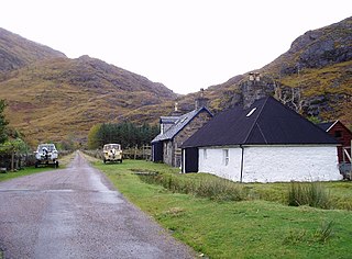
Kinloch Hourn is a small settlement at the end of Loch Hourn, in the West Highlands of Scotland. The name comes from the Gaelic, Ceann Loch Shubhairne, for "the head of Loch Hourn". Kinloch Hourn is at the end of 35 km of single-track road, which runs west from a junction with the A87 beside Loch Garry.

Luinne Bheinn is a mountain in the Northwest Highlands of Scotland, on the Knoydart Peninsula in Lochaber.

Glas Bheinn Mhor is a mountain in the Grampian Mountains of Scotland, south of Glen Etive. The Argyll and Bute and Highland border straddles its summit.

Beinn Bheag is a mountain in the Northwest Highlands of Scotland. It lies in the Ardgour area of Lochaber, west of the village of Corran.

Sgùrr nan Eag is a mountain 924 metres (3,031 ft) high in the Cuillin range on the Isle of Skye, Scotland. It is the southernmost Munro of the Cuillins and it lies between Coir' a' Ghrunnda to the west, Gars-bheinn to the east, and Garb-choire to the north.


