Waun Camddwr

Last updated

Waun Camddwr
Gwauncam.JPG
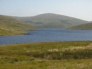
The summit of Waun Camddwr with Aran Fawddwy (behind)
Highest point
Elevation 622 m (2,041 ft)
Prominence 16 m (52 ft)
Parent peak Aran Fawddwy
Listing Nuttall
Naming
Language of name Welsh
Geography
Location Gwynedd, Wales
Parent range Snowdonia
OS grid SH847205
Topo map OS Landranger 124

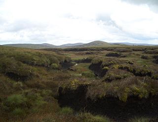
Waun Camddwr is a top of Aran Fawddwy in the south of the Snowdonia National Park in Gwynedd, Wales. It is the highest point on a wide boggy area between the summits of Aran Fawddwy and Glasgwm. It was surveyed after the first Nuttall list was compiled, and found to have just enough prominence to be included. The summit is a rocky outcrop amid an area of heather, long grass and peat bog. Gwaun y Llwyni rises to the south of the summit. [1]

Aran Fawddwy mountain in southern Snowdonia, Wales, United Kingdom

Aran Fawddwy is a mountain in southern Snowdonia, Wales, United Kingdom. It is the only peak in Wales outside North Snowdonia above 900m, and higher than anywhere in Great Britain outside Northern Snowdonia, the Scottish Highlands and the Lake District. The nearest urban centres to the mountain are Dinas Mawddwy to the south, Llanymawddwy to the southeast, Llanuwchllyn on the shores of Bala Lake to the north, and Rhydymain to the west. The nearest settlements with around 2,000 people are Bala and Dolgellau. On the eastern slopes of Aran Fawddwy is the small lake named Creiglyn Dyfi, the source of the River Dyfi. Its sister peak is Aran Benllyn at 885 metres (2,904 ft). There is also a middle peak- Erw y Ddafad-ddu.

Gwynedd A county in Wales, adjacent to Powys, Conwy, Anglesey, and Ceredigion

Gwynedd is a county in Wales, sharing borders with Powys, Conwy, Denbighshire, Anglesey over the Menai Strait, and Ceredigion over the River Dyfi. The scenic Llŷn Peninsula and most of Snowdonia National Park are in Gwynedd. Bangor is the home of Bangor University. In the northern part of the county, the other main settlements are Caernarfon, Bethesda, Ffestiniog, Llanddeiniolen, Llanllyfni, Porthmadog and Pwllheli. The largest settlement in the south is Tywyn.

Wales Country in northwest Europe, part of the United Kingdom

Wales is a country that is part of the United Kingdom. It is bordered by England to the east, the Irish Sea to the north and west, and the Bristol Channel to the south. It had a population in 2011 of 3,063,456 and has a total area of 20,779 km2 (8,023 sq mi). Wales has over 1,680 miles (2,700 km) of coastline and is largely mountainous with its higher peaks in the north and central areas, including Snowdon, its highest summit. The country lies within the north temperate zone and has a changeable, maritime climate.

Related Research Articles

Maesglase 678m high mountain in Wales

Maesglase is a mountain in Snowdonia, North Wales, situated approximately four miles to the south-west of Aran Fawddwy. It is the highest of the "Dyfi Hills".

Pen Pumlumon Llygad-bychan is a subsidiary summit of Pen Pumlumon Fawr and the third highest summit on the Plynlimon massif, a part of the Cambrian Mountains in the county of Ceredigion, Wales. It is not named on Ordnance Survey walking maps.

Y Garn (Plynlimon)

Y Garn is a subsidiary summit of Pen Pumlumon Fawr and the fourth highest peak on the Plynlimon massif, a part of the Cambrian Mountains in the county of Ceredigion, Wales.

Pen Pumlumon Arwystli is the second highest summit on the Plynlimon massif, a part of the Cambrian Mountains in the county of Ceredigion, Wales.

Gwaun Lydan mountain in United Kingdom

Gwaun Lydan is top of Aran Fawddwy in the south of the Snowdonia National Park in Gwynedd, Wales. It is located at the end of the south ridge. The summit comprises a small boggy plateau, the highest point being a peat hag marked by a few stones.

Gwaun y Llwyni mountain in United Kingdom

Gwaun y Llwyni is a subsidiary summit of Aran Fawddwy in southern Snowdonia, Wales. It forms a part of the Aran mountain range.

Foel Hafod-fynydd mountain in United Kingdom

Foel Hafod-fynydd is a subsidiary summit of Aran Fawddwy in southern Snowdonia, North Wales, Wales, United Kingdom. It tops the east ridge of Erw y Ddafad-ddu. Creiglyn Dyfi nestles in the bowl between Foel Hafod-fynydd and Aran Fawddwy.

Erw y Ddafad-ddu mountain in United Kingdom

Erw y Ddafad-ddu is a subsidiary summit of Aran Fawddwy in southern Snowdonia, North Wales, Wales, United Kingdom. It is the third highest peak in the Aran mountain range.

Aran Benllyn mountain in United Kingdom

Aran Benllyn is a subsidiary summit of Aran Fawddwy in southern Snowdonia, North Wales, Wales, United Kingdom. It is the second highest peak in the Aran mountain range.

Gau Graig 683m high mountain in Wales

Gau Graig is a subsidiary summit of Cadair Idris in the Snowdonia National Park, in Gwynedd, northwest Wales. It lies to the east of Mynydd Moel on a broad grassy plateau. It marks the eastern end of the Cadair Idris ridge.

Glasgwm mountain in United Kingdom

Glasgwm is a mountain in Gwynedd, Wales forming part of the Aran range in southern Snowdonia. It is one of the three Marilyns that make up the range, the others being Aran Fawddwy and Esgeiriau Gwynion. To the west is Maesglase and the Dyfi hills, while to the south-west lies Cadair Idris. To the south lies the Plynlimon range. It is 779 metres (2,556 ft) high.

Carnedd y Filiast (Cerrigydrudion) mountain in United Kingdom

Carnedd y Filiast is a mountain near Cerrigydrudion on the border of the Snowdonia National Park, North Wales and is 669 metres (2,195 ft) high.

Foel y Geifr mountain in United Kingdom

Foel y Geifr is a subsidiary summit of Esgeiriau Gwynion, and included in a group of hills known as the Hirnantau. These hills rise from the south east shores of Llyn Tegid. Confusion arises when trying to establish to which mountain range these belong to. Since, Foel y Geifr forms part of the Hirnant horseshoe, many consider it to be a Berwyn peak. However, geographically it belong to the Aran Fawddwy group, its parent peak being Esgeiriau Gwynion. It is the eastern outpost of the Arans.

Esgeiriau Gwynion mountain in the United Kingdom

Esgeiriau Gwynion is a mountain in north east Wales. It is the smallest of the three Marilyns that form the Aran range, the others being Aran Fawddwy and Glasgwm.

Foel Goch (Arenigs) mountain in United Kingdom

Foel Goch is a mountain in north-east Wales, and forms part of the Arenig mountain range. It is the only member of the Arenig group that lies outside of the Snowdonia National Park.

Waun-oer 670m high mountain in Wales

Waun-oer is a mountain in Snowdonia, North Wales, situated approximately four miles to the south-west of Aran Fawddwy. It is one of the peaks in the Dyfi hills, a subgroup of the Cadair Idris group. It is a top of Maesglase and the summit consists of a trig point that crowns an uneven grassy plateau. It is connected to Cribin Fawr to the east. To the north lies Cadair Idris, while Tarren y Gesail lies to the west.

Pen yr Allt Uchaf mountain in United Kingdom

Pen yr Allt Uchaf is a subsidiary summit of Aran Fawddwy in the south of the Snowdonia National Park in Gwynedd, Wales. The summit is the highest point on a ridge branching off to the west of Aran Fawddwy's south ridge.

Llechwedd Du mountain in United Kingdom

Llechwedd Du is a subsidiary summit of Esgeiriau Gwynion in north east Wales. It forms a long peat bog plateau that start at the end of Esgeiriau Gwynion's south ridge, and ends with the higher summit of Moel y Cerrig Duon.

Moel y Cerrig Duon mountain in United Kingdom

Moel y Cerrig Duon is a subsidiary summit of Esgeiriau Gwynion in Gwynedd in north east Wales.

References

  1. Nuttall, John & Anne (1999). The Mountains of England & Wales - Volume 1: Wales (2nd edition ed.). Milnthorpe, Cumbria: Cicerone. ISBN   1-85284-304-7.

Coordinates: 52°47′16.35″N3°41′18.10″W / 52.7878750°N 3.6883611°W / 52.7878750; -3.6883611

Geographic coordinate system Coordinate system

A geographic coordinate system is a coordinate system that enables every location on Earth to be specified by a set of numbers, letters or symbols. The coordinates are often chosen such that one of the numbers represents a vertical position and two or three of the numbers represent a horizontal position; alternatively, a geographic position may be expressed in a combined three-dimensional Cartesian vector. A common choice of coordinates is latitude, longitude and elevation. To specify a location on a plane requires a map projection.