Landscape
At 1181 metres (3875 feet), it is the second highest mountain north of the Great Glen (after neighbouring Càrn Eige) and the fourteenth highest in the United Kingdom. Càrn Eige stands just one kilometre to the north of Mam Sodhail and the two are regarded as twin mountains, being roughly identical in height and appearance. They stand together above Gleann nam Fiadh (Glen of the Deer) and are linked by a high col of around 1045 metres, making the traverse of the two mountains a natural day's walk.
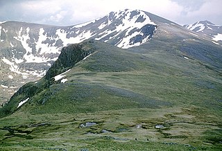
Mam Sodhail is mostly grassy without too much rock, however its sheer size, long ridges, and fine corries together with its four "tops" named in the Munro Tables make it a first-rate mountain. The hill casts three ridges down towards Glen Affric, the most impressive of these being the east southeast ridge, which has two "tops" on it; Mullach Cadha Rainich (996 metres) stands at the midpoint of the ridge which runs for four kilometres to conclude at the other “top” of Sgurr na Lapaich (1036 metres), which is the most prominent part of the mountain when viewed from Glen Affric. It has the characteristics of a separate mountain and was regarded as a Munro in the original 1891 list, with Irvine Butterfield saying, "The peak certainly does not lack character and many were disappointed to find that its original status was not restored in the seventh edition of Munros Tables". [3] The other two ridges, which form a horseshoe around the Allt Coulavie valley to the south of the summit, carry the “tops” of An Tudair (1074 metres) and Creag Coire nan Each (1055 metres). [4] [5] The mountain's western flanks fall away towards Gleann a’ Choilich, which drains northwards into Loch Mullardoch.
Summit
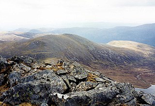
Mam Sodhail was an important part of the Ordnance Survey’s initial mapping of the northern Highlands in the 1840s, and the summit carries a massive cairn which was used by the surveyors in their work. The cairn is hollow and its walls have to be climbed to get inside. [6] Unusually, there is a visitors' book inside the cairn. [7] A few feet below the summit is the remains of a small bothy, complete with walls, fireplace and a chimney, which was formerly used by deerstalkers and watchers to keep sheep and walkers off the mountain. The bothy was mentioned by Sir Hugh Munro in volume one of the Scottish Mountaineering Club Journal along with tips to circumvent it and its inhabitants. [8] There is evidence of some quarrying south-west of the main summit on the ridge to Creag Coire nan Each. There are a number of pits about three metres deep and several metres across, and it is probable that this was the source of the stone for the summit cairn and the bothy. [9]
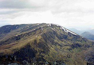
Carn Eighe is a mountain in the Northwest Highlands of Scotland. Rising to 1,183 metres (3,881 ft) above sea level, it is the highest mountain in Scotland north of the Great Glen, the twelfth-highest in the British Isles, and, in terms of relative height, it is the second-tallest mountain in the British Isles after Ben Nevis. Carn Eighe lies between Glen Affric and Loch Mullardoch, and is at the heart of a massif along with its twin peak, the 1,181-metre (3,875 ft) Mam Sodhail.

Slioch is a mountain in the Scottish Highlands situated in Wester Ross, eight kilometres north of the village of Kinlochewe. Slioch reaches an elevation of 981 metres and towers above the southeastern end of Loch Maree to give one of the best known and most photographed sights in the Highlands. VisitScotland, the Scottish national tourist agency, has used video footage of Slioch in its television advertisements.

Sgùrr nan Ceathreamhnan is a mountain in the Northwest Highlands of Scotland. It lies between Glen Affric and Glen Elchaig, some 30 kilometres east of Kyle of Lochalsh. With a height of 1,151 metres (3,776 ft) it is classed as a Munro and ranked as the third highest mountain north of the Great Glen.

Sgurr na Lapaich is a mountain in the Northwest Highlands of Scotland, situated north of Loch Mullardoch in the high ground that separates Glen Cannich and Glen Strathfarrar. The mountain reaches a height of 1,150 metres, and is the fourth-highest mountain north of the Great Glen. There is no higher ground to the north of it in Great Britain.

Mullach nan Coirean or Sgùrr a' Chaorainn is one of the Mamores mountains in the Scottish Highlands. It reaches a height of 939 metres (3081 feet) and is the most westerly of the ten Munros in the Mamores. It has a lower peak to the west, Meall a' Chaorainn. To the east, it is linked to the neighbouring mountain Stob Bàn by a bealach at a height of 846 metres; these two Munros are often climbed together from Glen Nevis.

Sgùrr Fhuaran is a Scottish mountain that is situated on the northern side of Glen Shiel, 23 kilometres (14 mi) east south east of Kyle of Lochalsh.

Sgùrr na Ciste Duibhe or Sgùrr nan Cisteachan Dubha is a mountain in the Northwest Highlands of Scotland, one of the 'Five Sisters of Kintail'. It is on the northern side of Glen Shiel, 27 kilometers southeast of Kyle of Lochalsh. Its height is 1,027 metres (3,369 ft) and it is classed as a Munro.

Aonach Meadhoin is a Munro mountain situated in the Kintail region of Scotland. It stands on the northern side of Glen Shiel some 31 kilometres south east of Kyle of Lochalsh.

Sgùrr a' Bhealaich Dheirg is a mountain in Kintail on the northern side of Glen Shiel in the Scottish Highlands. With a height of 1,036 metres (3,399 ft), it is classed as a Munro. It is the highest of three Munros known as the "Brothers of Kintail" in contrast to the Five Sisters of Kintail which lie just to the west.

Gairich, sometimes Sgurr Gairoch, is a mountain in Lochaber in the Northwest Highlands of Scotland. It is on the southern side of Loch Quoich, with Glen Garry to the east and Glen Kingie to the south, 25 kilometres north-northwest of Fort William.

Sròn a’ Choire Ghairbh is a Scottish mountain situated on the northern side of Loch Lochy, 13 kilometres north of Spean Bridge in the Highland Council area.
An Riabhachan is a Scottish mountain in the Skye and Lochalsh district of the Highland council area. It is situated 35 kilometres east of Kyle of Lochalsh standing in an isolated position at the western end of Loch Mullardoch, ten kilometres from any public road.
Càrn nan Gobhar is a mountain rising to 993 metres (3,258 ft) in the Northwest Highlands of Scotland. It stands on the northern side of Loch Mullardoch in the upper part of Glen Cannich, in a remote group of four Munros informally known as "The Mullardochs" which form the high ground between Loch Mullardoch and Loch Monar.
Creag Mhòr is a mountain in the Breadalbane region of the Scottish Highlands. It is in the Forest of Mamlorn, ten kilometres northeast of Tyndrum, and is one of the remotest of the southern Highlands Creag Mhòr reaches a height of 1047 metres (3435 ft) and qualifies as a Munro and a Marilyn. It is often climbed with the neighbouring Munro of Beinn Heasgarnich; the two mountains form the high ground between Glen Lochay and Loch Lyon.

Càrn Mairg is a mountain in the Breadalbane region of the Scottish Highlands, with a height of 1,042 metres (3,419 ft). It stands in a group of four Munro mountains known as the 'Càrn Mairg group', on the north side of Glen Lyon, Perthshire.

Càrn a' Gheòidh or Càrn Gheòidh is a mountain in the Mounth region of the Scottish Highlands. It lies 15 km south of the town of Braemar. Its summit stands on the border between the council areas of Perth and Kinross and Aberdeenshire.

Maoile Lunndaidh or Maoil Lunndaidh is a Scottish mountain situated 13 km south of Achnasheen in the Ross and Cromarty district of the Highland council area. It is part of the high ground between Loch Monar and Gleann Fhiodhaig.

Sgùrr Thuilm is a mountain in the Glenfinnan area of the Highlands of Scotland. It stands at the head of Glen Finnan approximately 7 kilometres (4 mi) north of Loch Shiel.

Mullach Fraoch-choire is a 1,102-metre (3,615 ft) mountain – a Munro – in the Northwest Highlands of Scotland on a ridge extending north for 8 kilometres (5.0 mi) between Loch Cluanie in Glenmoriston and upper Glen Affric. It is within the Glen Affric National Scenic Area and Glen Affric National Nature Reserve.


