Dale Head

Last updated

Dale Head
Dale Head.jpg
Dale Head seen from the neighbouring hill of High Spy
Highest point
Elevation 753 m (2,470 ft)
Prominence 397 m (1,302 ft)
Parent peak Great Gable
Listing Hewitt, Marilyn, Nuttall, Wainwright
Coordinates 54°31′37″N3°12′07″W / 54.527°N 3.20208°W / 54.527; -3.20208
Geography
Lake District National Park UK relief location map.png
Red triangle with thick white border.svg
Dale Head
Location relief map United Kingdom Allerdale.svg
Red triangle with thick white border.svg
Dale Head
Location in Allerdale, Cumbria
Location Cumbria, England
Parent range Lake District, North Western Fells
OS grid NY223153
Topo map OS Landrangers 89, 90, Explorer OL4

Dale Head is a fell in the north-western sector of the Lake District, in northern England. It is 753 metres (2,470 feet) above sea level and stands immediately north of Honister Pass, the road between Borrowdale and Buttermere.

Contents

Topography

The North-Western Fells occupy the area between the rivers Derwent and Cocker, a broadly oval swathe of hilly country, elongated on a north-south axis. Two roads cross from east to west, dividing the fells into three convenient groups. Dale Head is the highest fell in the southern sector.

Dale Head is the apex of two hill ridges. The principal ridge descends from Dale Head to the north-east and forms several other fells, each given a chapter by Alfred Wainwright in his Pictorial Guides to the Lakeland Fells. These are High Spy, Maiden Moor and Catbells (alternative spelling, Cat Bells). This ridge forms the western side of Borrowdale and overlooks Derwent Water. The other ridge descends to the north-west and includes the fells of Hindscarth and Robinson; it overlooks Gatescarthdale and Buttermere.

Dale Head is named for its position at the head of the Newlands Valley. This stretches away due north for three and a half miles before debouching into the floodplain of the Derwent between Derwentwater and Bassenthwaite Lake. The eastern wall of the valley is formed by the High Spy to Catbells ridge, separating it from Borrowdale. Entering on the western side are a series of side valleys which drain the main mass of the North Western Fells. The source of Newlands Beck does not however flow from the apex of Dale Head as might be supposed from the name. Instead it has its birth at the col between the main summit and the eastern top, High Scawdel (1,815 feet or 553 metres). The northern face of the fell forming the dalehead is ringed with crags. The main faces are Dalehead Crags and Great Gable, not to be confused with the fell of that name.

The southern flank of the fell running down to the summit of the Honister Pass road (1,180 feet or 360 metres) has much gentler slopes, although there is outcropping rock on either side. Buckstone Hows and Yew Crag overshadow the road. From the top of the pass Gatesgarthdale Beck runs north west to Buttermere while Hause Gill flows east to Seatoller and Borrowdale. Across the road is Grey Knotts in the Western Fells.

The ridge to Hindscarth departs north west from the summit of Dale Head, soon narrowing into the fine and airy Hindscarth Edge. Both slopes are rocky, that to the south being known as Molds. Far Tongue Gill descends from the north of the ridge, a tributary of Newlands Beck.

Although High Scawdel stands east of the main summit, the high ground takes a great loop to the south around the head of Newlands Beck. It then drives north to the depression at Wilson's Bield (1,655 feet or 504 metres) before climbing to the summit of High Spy. The rest of the North Western Fells bear no tarns worthy of the name, but Dale Head has two. On the northern slope near the source of Newlands Beck is Dalehead Tarn, while the smaller Launchy Tarn lies near the top of High Scawdel. Dalehead Tarn is a shallow pool providing a popular stopping place for walkers. Its varied flora include water horsetail, sedge and bogbean. Launchy Tarn is smaller and may have been formed by overgrazing and erosion of the underlying peat. [1]

Geology

Dale Head stands at the junction of the two main Lakeland geological systems, the Skiddaw slates to the north and the Borrowdale Volcanics to the south. On the northern flanks are outcrops of the Buttermere Formation, olistostrome of disrupted sheared mudstone, siltstone and sandstone. Southward march the Borrowdale series beginning with the plagioclase-phyric andesite lavas of the Birker Fell Formation, visible near the summit. [2]

The fell has seen extensive mining history. Dale Head Mine was driven below the northern crags for copper, several levels still being visible. Long Work was another copper mine a little further down the valley, worked for malachite and pyrite from Elizabethan times. On the southern flank of the fell, centred on the head of the pass, are the Honister Quarries. These are an extensive system of underground quarries, worked for Green Slate. The earliest extant records date from 1728 and since then huge caverns have been carved out on either side of the pass. The Yew Crag workings on the Dale Head side were operated until 1966, operations on the slopes of Grey Knotts continuing. In 1887 work began to drive a tunnel right under Dale Head into Newlands Valley, connecting with a proposed tramway to join the railway at Keswick. The scheme was abandoned after opposition from landowners. The main workers accommodation at the mine is now the Honister Hause Youth Hostel. [3]

Summit

The view of the Newlands Valley and Skiddaw from Dale Head summit cairn . Dale Head Summit 1.JPG
The view of the Newlands Valley and Skiddaw from Dale Head summit cairn .

The summit is marked by a cairn standing on the brink of the northern face. There is a fine end-on view of the Newlands Valley to the north, backed by Skiddaw. All around are rank upon rank of fells, of the major Lakeland ranges only the High Street group not being fully visible. [4] [5]

Ascents

One of the most popular ascent routes of Dale Head begins from the summit of Honister Pass, where there is a car park and a youth hostel. The route ascends directly alongside a fence for approximately 2 kilometres (1+14 miles) and would take the average walker some 45 or 50 minutes. Longer routes begin at Little Town in the Newlands Valley, climbing either via Dalehead Tarn or the old access track to Dale Head Mine. From Borrowdale a start can be made at either Seatoller or Longthwaite, ascending first to Launchy Tarn and High Scawdel. [4]

Related Research Articles

<span class="mw-page-title-main">Robinson (Lake District)</span>

Robinson is a fell in the English Lake District, its southern slopes descending to Buttermere, while its northern side is set in the Newlands Valley. Paths lead to the summit from the village of Buttermere, from the nearby summit Dale Head and from various locations in the valleys to the north.

<span class="mw-page-title-main">Borrowdale</span> Human settlement in England

Borrowdale is a valley and civil parish in the English Lake District in Cumberland, England. It is in the ceremonial county of Cumbria, and is sometimes referred to as Cumberland Borrowdale to distinguish it from another Borrowdale in the historic county of Westmorland.

<span class="mw-page-title-main">Grasmoor</span> Mountain in the English Lake District, Cumbria, England

Grasmoor is a mountain in the north-western part of the Lake District, northern England. It is the highest peak in a group of hills between the villages of Lorton, Braithwaite and Buttermere, and overlooks Crummock Water.

<span class="mw-page-title-main">Cat Bells</span> Mountain in Cumbria, England

Cat Bells is a fell in the English Lake District in the county of Cumbria. It has a height of 451 metres (1,480 ft) and is one of the most popular fells in the area. It is situated on the western shore of Derwentwater within three miles of the busy tourist town of Keswick. Its distinctive shape catches the attention of many visitors to the Lakes who feel compelled to climb to the summit after seeing it from the viewpoint of Friars' Crag on the opposite side of Derwentwater. The Lake District writer and walker Alfred Wainwright acknowledges the popularity of Cat Bells among fellwalkers of all abilities by saying:

"It is one of the great favourites, a family fell where grandmothers and infants can climb the heights together, a place beloved. Its popularity is well deserved: its shapely topknott attracts the eye offering a steep but obviously simple scramble."

<span class="mw-page-title-main">Haystacks (Lake District)</span> Fell in the Lake District, Cumbria, England

Haystacks, or Hay Stacks, is a hill in England's Lake District, situated at the south-eastern end of the Buttermere Valley. Although not of any great elevation, Haystacks has become one of the most popular fells in the area. This fame is partly due to the writings of Alfred Wainwright, who espoused its attractions and chose it as the place where he wanted his ashes scattered. Its large, undulating summit contains many rock formations, tarns and hidden recesses.

<span class="mw-page-title-main">Crag Hill</span>

Crag Hill is a mountain in the North Western part of the English Lake District. It was formerly known as Eel Crag; however, the Ordnance Survey now marks Eel Crag as referring to the northern crags of the fell. It is not to be confused with another Crag Hill lying on the border of North Yorkshire.

<span class="mw-page-title-main">Kirk Fell</span> Fell in the Lake District, England

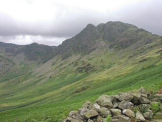
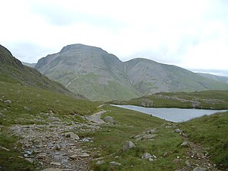
Kirk Fell is a fell in the Western part of the English Lake District. It is situated between Great Gable and Pillar on the long ring of fells surrounding the valley of Ennerdale, and also stands over Wasdale to the south. However, it is separated from its two higher neighbours by the low passes of Black Sail and Beck Head, giving it a high relative height and making it a Marilyn, the thirteenth highest in the Lake District.

<span class="mw-page-title-main">Causey Pike</span> Mountain in Cumbria, England

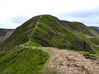
Causey Pike is a fell in the English Lake District. It is situated in the Newlands Valley, 5 kilometres south-west of the town of Keswick. Even though it has a modest height of 637 metres (2,090 ft) it is one of the most distinctive fells when viewed from the Derwent Water and Keswick area due to its distinguishing summit "knobble" which catches the eye. The fell is one of 214 fells described by Alfred Wainwright in his series of Pictorial Guides to the Lakeland Fells: Causey Pike features in Book Six, The North Western Fells.

<span class="mw-page-title-main">Hindscarth</span>

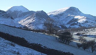
Hindscarth is a mountain between the valleys of Buttermere and Newlands, in the north-western part of the English Lake District. The fell's name is derived from two words from the Old Norse language, Hind and Skarth, and means the pass used by the red deer.

<span class="mw-page-title-main">Glaramara</span> Mountain in the English Lake District, Cumbria, England

Glaramara is a fell in the English Lake District in Cumbria. It is a substantial fell that is part of a long ridge that stretches for over six kilometres from Stonethwaite in Borrowdale up to the important mountain pass of Esk Hause. The summit of Glaramara at 783 metres (2,569 ft) is the central point of this ridge, which separates the valleys of Langstrath and Grains Gill. However, the ridge has two additional fells, numerous subsidiary tops and several small tarns making its traverse an appealing and challenging walk.

<span class="mw-page-title-main">Wandope</span> Fell in the Lake District, Cumbria, England

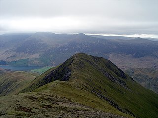
Wandope (also known as Wanlope is a fell in the north-western area of the English Lake District. It lies to the east of Crummock Water and south of Crag Hill. From the summit there are excellent panoramas of the Sca Fell and High Stile ranges.

<span class="mw-page-title-main">Whiteless Pike</span> Fell in England

Whiteless Pike, 660 metres (2,170 ft) high, is a fell in the north-western English Lake District. It stands immediately east of Crummock Water and forms a pyramid shape when viewed from Rannerdale. In his celebrated guide to the Lakeland fells, A Wainwright called it "the Weisshorn of Buttermere". There are good views of Great Gable and the Scafells from the summit.

<span class="mw-page-title-main">Green Gable</span> Mountain in the Lake District, England

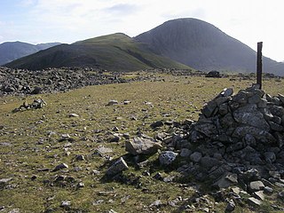
Green Gable is a fell in the English Lake District often traversed by walkers en route to its more famous neighbour Great Gable. It can be ascended from Honister Pass, Seathwaite in Borrowdale, or Ennerdale. There are good views of Gable Crag, Scafell Pike and the Buttermere valley from the summit.

<span class="mw-page-title-main">Maiden Moor</span>

Maiden Moor is a fell in the English Lake District, it stands 6 km south of the town of Keswick and is part of the high ground that separates the Newlands Valley and Borrowdale, it has a modest height of 576 m (1,890 ft) and so fails to be mentioned on many UK mountain lists but it does have a separate chapter in Alfred Wainwright’s Pictorial Guide to the Lakeland Fells.

<span class="mw-page-title-main">High Spy</span> Mountain in the English Lake District, Cumbria, England

High Spy is a fell in the English Lake District it is situated on the ridge that separates the Newlands Valley from Borrowdale, eight kilometres south of Keswick.

<span class="mw-page-title-main">Grey Knotts</span> Fell in the Lake District, Cumbria, England

Grey Knotts is a fell in the English Lake District. It is situated one kilometre south of the B5289 road as it crosses the Honister Pass. It is well seen from mid-Borrowdale as it rises above Seatoller. Grey Knotts reaches a height of 697 metres and is part of a ridge which ascends from the woodland behind Seatoller and continues south-west and then south for four kilometres to Great Gable. The fell's name really only applies to the summit rocks, but has been adopted for the entire fell with the high ground in this area, locally known as Seatoller Fell on Ordnance Survey maps.

<span class="mw-page-title-main">Sail (Lake District)</span>

Sail is a hill in the English Lake District, lying between Derwentwater and Crummock Water.

<span class="mw-page-title-main">Brandreth</span> Fell in the Lake District, Cumbria, England

Brandreth is a fell in the English Lake District. It stands between Great Gable and Haystacks in the Western Fells.

<span class="mw-page-title-main">Northern Fells</span>

The Northern Fells are a part of the Cumbrian Mountains in the Lake District of England. Including Skiddaw, they occupy a wide area to the north of Keswick. Smooth, sweeping slopes predominate, with a minimum of tarns or crags. Blencathra in the south-east of the group is the principal exception to this trend.

<span class="mw-page-title-main">North Western Fells</span>

The North Western Fells are a part of the Cumbrian Mountains in the Lake District of England. Including such favourites as Catbells and Grisedale Pike, they occupy an oval area beneath the Buttermere and Borrowdale valley systems. The North Western Fells are characterised by soaring east-west ridges and an absence of mountain tarns.

References

  1. Blair, Don: Exploring Lakeland Tarns: Lakeland Manor Press (2003): ISBN   0-9543904-1-5
  2. British Geological Survey: 1:50,000 series maps, England & Wales Sheet 29: BGS (1999)
  3. Adams, John: Mines of the Lake District Fells: Dalesman (1995) ISBN   0-85206-931-6
  4. 1 2 Alfred Wainwright: A Pictorial Guide to the Lakeland Fells, Book 6, The North Western Fells: Westmorland Gazette (1964): ISBN   0-7112-2459-5
  5. Birkett, Bill: Complete Lakeland Fells: Collins Willow (1994): ISBN   0-00-218406-0