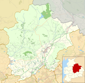
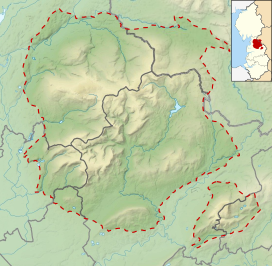
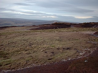
The Forest of Bowland, also known as the Bowland Fells and formerly the Chase of Bowland, is an area of gritstone fells, deep valleys and peat moorland, mostly in north-east Lancashire, England, with a small part in North Yorkshire. It is a western outlier of the Pennines.

Ribble Valley is a local government district with borough status in Lancashire, England. Its council is based in Clitheroe, the largest town. The borough also includes the town of Longridge and numerous villages and surrounding rural areas. It is named after the River Ribble. Much of the district lies within the Forest of Bowland, a designated Area of Outstanding Natural Beauty.

Parlick is an approximately cone-shaped steep-sided hill at the extreme south of the main range of Bowland fells in Lancashire, England. Its bog-free sides make it more popular with walkers than the shallow boggy hills to its north. Paths zigzag up this hill from the south, or for the more strenuous ascent a straight path can be chosen. This hill is usually green — different from the often thorny brown to red of the northern hills. A thin neck joins Parlick onto Fair Snape Fell with well-worn paths linking the two.

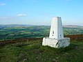
Fair Snape Fell is one of the larger hills in the Forest of Bowland in Lancashire, England. It reaches 521.9 m (1,712 ft) with a prominence of 226.2 m (742 ft) and is classed as a Marilyn. It occupies a position in the very south of the main range of fells, alongside and just to the north of Parlick, to which it is joined by a ridge. The main paths approach the summit from Parlick in the south, Saddle Fell in the east and Bleasdale in the valley to the west. The Saddle Fell approach is as boggy as the hills to the north. The summit is covered in grass and peat groughs. A trig point and large cairn occupy the top of the western escarpment, with the highest point being about 700 metres (770 yd) to the north-east.

The Amounderness Hundred is one of the six subdivisions of the historic county of Lancashire in North West England, but the name is older than the system of hundreds first recorded in the 13th century and might best be described as the name of a Norse wapentake. In the Domesday Book of 1086, it was used for some territories north of the River Ribble included together with parts of Yorkshire. The area eventually became part of Lancashire, sitting geographically between the Rivers Lune and Ribble, in the strip of coast between the Irish Sea and Bowland Forest.

Bleasdale is a village and civil parish in the Wyre district of Lancashire, England, in the Forest of Bowland Area of Outstanding Natural Beauty. The two sources of the River Brock lie within the parish. According to the 2001 census, it had a population of 147, increasing to 167 at the 2011 Census.
Hawthornthwaite Fell is one of the larger hills in the Forest of Bowland in the north west of England. Hawthornthwaite Fell marks the extreme western limit of the West Riding of the historic county of York. Since 1974 it has fallen within the boundaries of the administrative county of Lancashire. However, most of the hill is on the Duke of Westminster's land. It occupies a north-facing position on the south-western range, close to Bleasdale and Fair Snape Fell. The only path to the summit comes over the hills from the south. The summit is boggy and flanked to the north by steep heather slopes. Grouse are farmed in the area and hen harriers can be seen frequently. The trig point and the remains of its foundations are no longer upright, lying horizontally pointing westward.

Goosnargh is a village and civil parish in the City of Preston district of Lancashire, England.

Mickle Fell is a mountain in the Pennines, the range of hills and moors running down the middle of Northern England. It has a maximum elevation of 788 m (2,585 ft). It lies slightly off the main watershed of the Pennines, about 10 miles south of Cross Fell. After Cross Fell, Mickle Fell is the highest Marilyn within the North Pennines designated Area of Outstanding Natural Beauty (AONB).
The River Hodder is in Lancashire, England. It is a County Biological Heritage Site.

Chipping is a village and civil parish in the borough of Ribble Valley, Lancashire, England, within the Forest of Bowland Area of Outstanding Natural Beauty. Its grid reference is SD6243, and the nearest substantial settlement is Longridge, nearly 4 mi (6.4 km) to the south. In the 2001 census, the parish had a population of 1,046, falling slightly to 1,043 at the 2011 census. The village has won several best-kept village competitions over the years. The village also won the village section of the Royal Horticultural Society Britain in Bloom competition in 2009, picking up RHS Tourism and Gold achievement awards in the process.
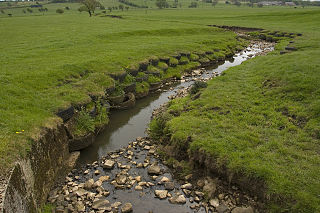
The River Loud is a river of Lancashire, England.
The Preston and Longridge Railway (P&LR) was a branch line in Lancashire, England. Originally designed to carry quarried stone in horse-drawn wagons, it became part of an ambitious plan to link the Lancashire coast to the heart of Yorkshire. The ambition was never achieved, but the line continued to carry passengers until 1930 and goods until 1967.

Beacon Fell is a fell in the civil parish of Goosnargh in Lancashire, England. The high ground, which rises to 266 m (873 ft), has been a country park since 1970. It is situated within the south westerly part of the Forest of Bowland, an Area of Outstanding Natural Beauty.

Gragareth is a mountain straddling the border between Lancashire and North Yorkshire in England. At 627 metres (2,057 ft), its summit is the second highest point in the post-1974 county of Lancashire. The highest point in modern Lancashire is Green Hill, approximately 3.2 km (2.0 mi) to the north and the Old Man of Coniston in the Furness Fells of the Lake District at 803 metres (2,635 ft) is the county top of the traditional county of Lancashire. The summit of Gragareth lies about 200 m west of the county boundary, but inside the 2016 border of Yorkshire Dales National Park. The western slopes are known as Leck Fell and the southern slopes form Ireby Fell.
Easington is a civil parish within the Ribble Valley district of Lancashire, England, with a population in 2001 of 52. The Census 2011 population details have been grouped with the parish of Slaidburn. Before 1974, it formed part of Bowland Rural District in the West Riding of Yorkshire. It covers just over 9000 acres.
A National Character Area (NCA) is a natural subdivision of England based on a combination of landscape, biodiversity, geodiversity and economic activity. There are 159 National Character Areas and they follow natural, rather than administrative, boundaries. They are defined by Natural England, the UK government's advisors on the natural environment.
The geology of Lancashire in northwest England consists in the main of Carboniferous age rocks but with Triassic sandstones and mudstones at or near the surface of the lowlands bordering the Irish Sea though these are largely obscured by Quaternary deposits.

Longridge Golf Club, in Longridge, England, was founded around 1915, making it one of the oldest golf clubs in the county of Lancashire. Situated on Longridge Fell's Forty Acre Lane, the elevation of the clubhouse is 744 feet (227 m), which is about 400 feet below that of the fell's peak. It is a par 70, 5,904-yard course.