Bowland-with-Leagram

Last updated

Bowland-with-Leagram
Leagram Hall - geograph.org.uk - 136139.jpg
Leagram Hall
Location map United Kingdom Borough of Ribble Valley.svg
Red pog.svg
Bowland-with-Leagram
Location in Ribble Valley
Location map United Kingdom Forest of Bowland.svg
Red pog.svg
Bowland-with-Leagram
Location in the Forest of Bowland
Lancashire UK location map.svg
Red pog.svg
Bowland-with-Leagram
Location within Lancashire
Area18.8702 km2 (7.2858 sq mi)
Population169 (2011 census)
  Density 9/km2 (23/sq mi)
OS grid reference SD635455
District
Shire county
Region
Country England
Sovereign state United Kingdom
Post town PRESTON
Postcode district PR3
Post townClitheroe
Postcode district BB7
Dialling code 01995
01254
Police Lancashire
Fire Lancashire
Ambulance North West
UK Parliament
List of places
UK
England
Lancashire
53°54′00″N2°33′36″W / 53.900°N 2.560°W / 53.900; -2.560 Coordinates: 53°54′00″N2°33′36″W / 53.900°N 2.560°W / 53.900; -2.560

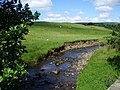
Bowland-with-Leagram is a civil parish in the Ribble Valley district of Lancashire, England, covering part of the Forest of Bowland. According to the census, the parish had a population of 181 in 1951, 128 in 2001 and 169 at the Census 2011. [1] [2]

Contents

As the only part of the historical Forest of Bowland that lay within the historical bounds of Lancashire, the area was known for many centuries by the name of Little Bowland and this name remains in common use today.

History

Leagram was a hunting park from at least the early twelfth century, being part of the ancient Lordship of Bowland [3] which comprised a Royal Forest and a Liberty of ten manors spanning eight townships and four parishes and covered an area of almost 300 square miles (800 km2) on the historic borders of Lancashire and Yorkshire. The manors within the Liberty were Leagram, Slaidburn (Newton-in-Bowland, West Bradford, Grindleton), Knowlmere, Waddington, Easington, Bashall Eaves, Mitton, Withgill (Crook),Hammerton and Dunnow (Battersby). [4]

As Lady Queen of Bowland, Elizabeth I alienated the park and granted the manor of Leagram to her favourite, the Earl of Leicester, in 1563. It was purchased shortly afterwards by Sir Richard Shireburne of Stonyhurst. Shireburne served as Master Forester of Bowland until 1594. The Shireburnes held the manor until 1754 before it passed to their cousins, the Welds. [5] The Shireburne family tombs are at All Hallows' Church, Great Mitton. John Weld-Blundell is the present-day Lord of the Manor of Chipping (Lawn).

Some of the earliest evidence of human settlement in eastern Lancashire has come from this corner of Bowland. In 1946, archaeologists uncovered artefacts, including pottery, indicating Bronze Age occupation at Fairy Holes, a cave situated on New Laund Farm, near Whitewell. [6]

Governance

The civil parish of Bowland-with-Leagram was created from the civil parishes of Little Bowland and Leagram in 1935 [7] (both created from townships in the ancient parish of Whalley in 1866 [8] [9] ).

See also

Related Research Articles

Forest of Bowland

The Forest of Bowland, also known as the Bowland Fells and formerly the Chase of Bowland, is an area of gritstone fells, deep valleys and peat moorland, mostly in north-east Lancashire, England, with a small part in North Yorkshire. It is a western outlier of the Pennines.

Reedley Hallows Human settlement in England

Reedley Hallows or Reedley is a civil parish in the Borough of Pendle in Lancashire, England. It forms part of Burnley and Brierfield. It had a population of 1,994, reducing to 1,960 at the 2011 Census.

Blackburn Hundred

Blackburn Hundred is a historic sub-division of the county of Lancashire, in northern England. Its chief town was Blackburn, in the southwest of the hundred. It covered an area similar to modern East Lancashire, including the current districts of Ribble Valley, Pendle, Burnley, Rossendale, Hyndburn, Blackburn with Darwen, and South Ribble.

Newton-in-Bowland Human settlement in England

Newton or Newton-in-Bowland is a village and civil parish in the Ribble Valley district, in the county of Lancashire, England, formerly known as Newton-on-Hodder. The civil parish had a population of 237 in 2001, according to the United Kingdom Census, increasing to 315 at the 2011 Census. The township covers almost 6,000 acres of the Forest of Bowland. Historically, the village is part of the West Riding of Yorkshire, but was transferred to Lancashire for administrative purposes on 1 April 1974, under the provisions of the Local Government Act 1972.

Bashall Eaves Village and civil parish in the Ribble Valley district of Lancashire, England

Bashall Eaves is a village and civil parish in the Ribble Valley district of Lancashire, England, about four miles (6 km) west of Clitheroe. The placename element eaves is Old English and refers to Bashall's location on the borders of the Forest of Bowland. Historically, the village is part of the West Riding of Yorkshire, but was transferred to Lancashire for administrative purposes on 1 April 1974, under the provisions of the Local Government Act 1972.

Slaidburn Human settlement in England

Slaidburn is a village and civil parish within the Ribble Valley district of Lancashire, England. The parish covers just over 5,000 acres of the Forest of Bowland.

Bowland Forest Low Human settlement in England

Bowland Forest Low is a civil parish in the Ribble Valley district of Lancashire, England, covering some 5,500 acres (22 km2) of the Forest of Bowland. According to the 2001 census, the parish had a population of 168, falling to 160 at the 2011 Census. The parish includes the hamlets of Whitewell and Cow Ark. From northwards clockwise, it borders the civil parishes of Newton, Bashall Eaves, Aighton, Bailey and Chaigley, Bowland-with-Leagram and Bowland Forest High. Before 1974, it formed part of Bowland Rural District in the West Riding of Yorkshire.

Bowland Forest High Human settlement in England

Bowland Forest High is a civil parish in the Ribble Valley district of Lancashire, England, covering some 20,000 acres (80 km2) of the Forest of Bowland. According to the 2001 census, the parish had a population of 163, falling to 144 at the 2011 Census. The parish includes the settlements of Hareden, Sykes, and Dunsop Bridge. It covers Sykes Fell, Whins Brow, Croasdale Fell and Wolfhole Crag. Before 1974, it formed part of Bowland Rural District in the West Riding of Yorkshire.

Waddington, Lancashire Human settlement in England

Waddington is a small village, 2 miles (3 km) north-west of Clitheroe in the Ribble Valley, Lancashire, England. The population of the civil parish at the 2011 census was 1,028. Before the 1974 county boundary changes, Waddington fell just within the Bowland Rural District of the West Riding of Yorkshire. It covers approximately 2000 acres of the Forest of Bowland.

Roughlee Human settlement in England

Roughlee is a village in Pendle, Lancashire, England, in the civil parish of Roughlee Booth. It is close to Nelson, Barrowford and Blacko. The village lies at the foot of Pendle Hill, well known for the Pendle Witches, and includes the hamlet of Crowtrees. The parish adjoins the Pendle parishes of Blacko, Barrowford, Old Laund Booth, Goldshaw Booth and Barley-with-Wheatley Booth. It is part of the Forest of Bowland Area of Outstanding Natural Beauty (AONB).

West Bradford, Lancashire Human settlement in England

West Bradford is a village and civil parish in Lancashire, England, 27 miles (43 km) west of the larger city of Bradford, West Yorkshire and 2.5 miles (4 km) north of Clitheroe. The population of the civil parish taken at the 2011 census was 788. It covers some 2000 acres of the Forest of Bowland. In Domesday, it is recorded as Bradeford and in the thirteenth century, Braford in Bouland. It was part of the West Riding of Yorkshire until 1974. "West Bradford" was introduced in the nineteenth century at the time of the introduction of postal services to help distinguish the village from its larger eastern neighbour of the same name.

Pendleton, Lancashire Human settlement in England

Pendleton is a small village and civil parish in Ribble Valley, within the county of Lancashire, England. It is close to the towns of Whalley and Clitheroe. The parish lies on the north west side of Pendle Hill below the Nick o' Pendle. The village is just off the A59, Liverpool to York main road, since the construction of the Clitheroe By-Pass. Older roads through the parish include one from Clitheroe to Whalley which passes through the Standen area and another to Burnley which passes Pendleton Hall.

Goldshaw Booth Human settlement in England

Goldshaw Booth is a civil parish in the Pendle district of Lancashire, England. It has a population of 248, and contains the village of Newchurch in Pendle and the hamlets of Spen Brook and Sabden Fold. Pendle Hill lies to the north.

Grindleton Human settlement in England

Grindleton is a village and civil parish in the Ribble Valley district of the English county of Lancashire, formerly in the West Riding of Yorkshire. Its 3,700 acres sit within the Forest of Bowland. The population of the civil ward taken at the 2011 census was 772.

Sawley, Lancashire Human settlement in England

Sawley is a village and civil parish in the Borough of Ribble Valley in Lancashire, England. The population of the civil parish was 305 at the 2001 Census, rising to 345 at the 2011 census. It is situated north-east of Clitheroe, on the River Ribble. It was historically part of the West Riding of Yorkshire.

Great Mitton Human settlement in England

Great Mitton is a village and a civil parish in the Ribble Valley, Lancashire, England. It is separated from the civil parish of Little Mitton by the River Ribble, both lie about three miles from the town of Clitheroe. The combined population of both civil parishes at the 2011 census was 266. In total, Great and Little Mitton cover less than 2000 acres of the Forest of Bowland, making it the smallest township in the Forest. Historically, the village is part of the West Riding of Yorkshire, but was transferred to Lancashire for administrative purposes on 1 April 1974, under the provisions of the Local Government Act 1972.

Horton, Lancashire Human settlement in England

Horton, historically known as Horton-in-Craven, is a village and a civil parish in the Ribble Valley district of the English county of Lancashire. Population details are now included in the civil parish of Newsholme. It is near the town of Barnoldswick. Horton has a place of worship, anciently called a chapelry or chapel of ease. For transport, there is the A59 nearby.

Easington, Lancashire Human settlement in England

Easington is a civil parish within the Ribble Valley district of Lancashire, England, with a population in 2001 of 52. The Census 2011 population details have been grouped with the parish of Slaidburn. Before 1974, it formed part of Bowland Rural District in the West Riding of Yorkshire. It covers just over 9000 acres.

Little Mitton civil parish in Lancashire, England

Little Mitton is a civil parish in the Ribble Valley district, in the county of Lancashire, England. In 2001 the population of the civil parish of Little Mitton was 42, but by the time of the census 2011 population details had been absorbed in the civil parish of Great Mitton. Little Mitton has a grade II* listed house called Mitton Hall. There is also Little Mitton Hall in Little Mitton.

Old Laund Booth Human settlement in England

Old Laund Booth is a civil parish in the Pendle district of Lancashire, England. It has a population of 1,459, and contains the villages of Fence and Wheatley Lane.

References

  1. "Parish headcount" (PDF). Lancashire County Council. Archived from the original (PDF) on 10 December 2006. Retrieved 27 December 2008.
  2. UK Census (2011). "Local Area Report – Bowland-with-Leagram Parish (1170215099)". Nomis. Office for National Statistics . Retrieved 1 March 2018.
  3. "Lord of the Fells, Guardian of History" (PDF). Rural Life. November 2014.
  4. Forest of Bowland official website
  5. John Weld, A History of Leagram: The Park and the Manor (Chetham Society: Manchester 1913)
  6. RC Musson, "A Bronze Age Cave Site in the Little Bolland Area of Lancashire", Transactions of the Lancashire and Cheshire Antiquarian Society, Vol 59: 161-170 (1948)
  7. "History of BOWLAND WITH LEAGRAM". visionofbritain.org.uk. Retrieved 1 March 2018.
  8. "History of LITTLE BOWLAND". visionofbritain.org.uk. Retrieved 1 March 2018.
  9. "History of LEAGRAM". visionofbritain.org.uk. Retrieved 1 March 2018.