Accrington is a town in the Hyndburn borough of Lancashire, England. It lies about 4 miles (6 km) east of Blackburn, 6 miles (10 km) west of Burnley, 13 miles (21 km) east of Preston, 20 miles (32 km) north of Manchester city centre and is situated on the mostly culverted River Hyndburn. Commonly abbreviated by locals to "Accy", the town has a population of 35,456 according to the 2011 census.

Ribble Valley is a local government district with borough status within the non-metropolitan county of Lancashire, England. The total population of the non-metropolitan district at the 2011 Census was 57,132. Its council is based in Clitheroe. Other places include Whalley, Longridge and Ribchester. The area is so called due to the River Ribble which flows in its final stages towards its estuary near Preston. The area is popular with tourists who enjoy the area's natural unspoilt beauty, much of which lies within the Forest of Bowland.

Whalley is a large village and civil parish in the Ribble Valley on the banks of the River Calder in Lancashire, England. It is overlooked by Whalley Nab, a large wooded hill over the river from the village. The population of the civil parish was 2,645 at the census of 2001, and increased to 3,629 at the census of 2011.

Lydiate is a village and civil parish in the Metropolitan Borough of Sefton on Merseyside, England but historically in Lancashire. It is located to the north of Maghull, with which it has a common history. At the 2001 Census the civil parish of Lydiate had a population of 6,672, reducing to 6,308 at the 2011 Census.

Whalley Range is an area of Manchester, England, about 2 miles (3.2 km) southwest of the city centre. The population at the 2011 census was 15,430. Historically in Lancashire, it was one of the earliest of the city's suburbs, built by local businessman Samuel Brooks.
Langho is a small rural village 5 miles (8 km) north of Blackburn in the Ribble Valley, Lancashire, England. It is part of the parish of Billington and Langho. The village is linked with Blackburn and Clitheroe by the A666 road and is served by Langho railway station on the Ribble Valley Line. The population at the 2011 census was 2,015.

Walcott is a small village and civil parish in the North Kesteven district of Lincolnshire, England. The population of the civil parish at the 2011 census was 566. It is situated approximately 2 miles (3 km) north from Billinghay and 7 miles (11 km) north-east from the town of Sleaford.

Billington and Langho is a civil parish in the Ribble Valley district of Lancashire, England, covering the villages of Billington and Langho and the hamlets of York and Old Langho and the gated community called Brockhall Village.

Chipping is a village and civil parish of the borough of Ribble Valley, Lancashire, England, within the Forest of Bowland Area of Outstanding Natural Beauty. In the 2001 census, the parish had a population of 1,046, falling slightly to 1,043 at the 2011 Census. This Lancashire village has won a number of best kept village competitions over the years. The village also won the village section of the Royal Horticultural Society Britain in Bloom competition in 2009 picking up RHS Tourism and Gold achievement awards in the process.

Cliviger is a civil parish in the Borough of Burnley, in Lancashire, England. It is situated to the southeast of Burnley, and northwest of Todmorden, having a population of 2,238. Although the whole parish lies within the Borough of Burnley it is actually split between three postal towns, with a few farms lying in either the Todmorden or Bacup postal areas.

Northchapel is a village and civil parish in Chichester District in West Sussex, England. It stands on the A283 road just south of the Surrey border, around 9 km north of Petworth.

Simonstone is a small village and civil parish in the Ribble Valley district of Lancashire, England. The population of the civil parish taken at the 2011 census was 1,154. It is about 4 miles (6 km) west of Burnley and south of Pendle Hill and Clitheroe along the A671 road. The village adjoins the village of Read, Lancashire and neighbours Padiham.

Brinscall is a village in the Borough of Chorley, Lancashire, England. Located approximately five miles north-east of Chorley, Brinscall borders the similar-sized villages of Withnell and Abbey Village. Brinscall is part of the civil parish of Withnell but does not have its own boundaries. However, an area used in the 2001 census that covers approximately the same area as the village had a population of 1,431. The village population at the 2011 census was 1,388.

Sabden is a medium-to-large village and civil parish in the Ribble Valley, Lancashire, England. Sabden is located south of Pendle Hill, in a valley about three miles north west of Padiham. The parish covers 2,450.9 acres (991.85 ha), of which 103.2 acres (41.75 ha) is occupied by the village. It lies in the Forest of Pendle section of the Forest of Bowland Area of Outstanding Natural Beauty.
Scarcliffe is a small village and civil parish in the Bolsover district of Derbyshire, England. It is sometimes called Scarcliffe with Palterton. The population of the parish at the 2001 UK Census was 5,211, increasing to 5,288 at the 2011 Census.

Peartree Green is an open space on high ground on the east bank of the River Itchen in Southampton. A 16/17th century building, Peartree House, still stands, though is today concealed by private housing. The house and the green take their name from a pear tree that grew near the parish church. Some of the original open space has been built on, but a large proportion remains as a recreational area. It contains a church and the remains of a boarding school. It overlooks the River Itchen to St Mary's Church in Southampton.

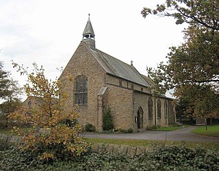
Old St Leonard's Church is a redundant Anglican church 1 mile (1.6 km) northwest of the village of Langho, Lancashire, England. It is recorded in the National Heritage List for England as a designated Grade I listed building, and is under the care of the Churches Conservation Trust.

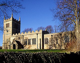
New St Leonard's Church is in Whalley New Road, between the villages of Langho and Billington in Lancashire, England. It is an active Anglican parish church in the deanery of Whalley, the archdeaconry of Blackburn, and the diocese of Blackburn.

Lancashire is a county in North West England. In 1974 parts of the historic county were divided between Greater Manchester, Merseyside, Cheshire and Cumbria, and part of the West Riding of Yorkshire was transferred into the county, creating the non-metropolitan county of Lancashire. Together with the unitary authorities of Blackburn with Darwen and Blackpool it now forms the ceremonial county of Lancashire.
Billington and Langho is a civil parish in Ribble Valley, Lancashire, England. It contains nine listed buildings that are recorded in the National Heritage List for England. Of these, two are listed at Grade I, the highest of the three grades, one is at Grade II*, the middle grade, and the others are at Grade II, the lowest grade. The parish contains the villages of Billington and Langho, and is otherwise mainly rural. The listed buildings are houses, farmhouses, a farm building, and a church.