Rimington

Last updated

Rimington
Memorial Institute Rimington 2.JPG
The Memorial Institute, built 1927
Location map United Kingdom Borough of Ribble Valley.svg
Red pog.svg
Rimington
Shown within Ribble Valley
Lancashire UK location map.svg
Red pog.svg
Rimington
Location within Lancashire
Population382  (2001 Census) [1]
OS grid reference SD806458
Civil parish
  • Rimington
District
Shire county
Region
Country England
Sovereign state United Kingdom
Post town CLITHEROE
Postcode district BB7
Dialling code 01200
Police Lancashire
Fire Lancashire
Ambulance North West
UK Parliament
List of places
UK
England
Lancashire
53°54′29″N2°17′42″W / 53.908°N 2.295°W / 53.908; -2.295

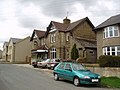
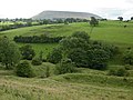
Rimington is a rural village and civil parish in the Ribble Valley, Lancashire, England. The population of the civil parish was 382 at the 2001 Census, however at the 2011 Census Middop was included with Rimington giving a total of 480. [2] It is east of Clitheroe and south of the A59 road. The village consists of the hamlets of Howgill, Martin Top, Newby, and Stopper Lane, and is in the historic West Riding of Yorkshire.

Contents

The parish adjoins the Ribble Valley parishes of Gisburn, Sawley, Downham, Twiston and Middop the Pendle parish of Barley-with-Wheatley Booth.

History

The village was listed in the Domesday Book as "Renistone". The name Boulton (Bolton) is listed in land deeds of 1302, [3] and Robert Elwald son of Alan listed 1304. [4]

Since Tudor times, until the late 19th century, lead mining was an important industry around the village. At one time silver was derived as a by-product of the mining, to the extent that Queen Elizabeth I declared the Stopper Lane Mine as being a Mine Royal. [5]

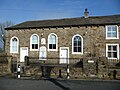
Francis Duckworth (1862–1941) was born in the village, and composed several hymn tunes including one named after the village. [6] There is a plaque to his memory was placed above the doorway to the former Methodist Chapel in Stopper Lane. Salem Chapel, the local Congregational Church at Martin Top, was founded in 1816 and continues to serve the area. [7] [8]

Rimington railway station opened in 1872 and closed in 1959, and was on the Ribble Valley Line.

Rimington Memorial Institute was built in 1927 to serve as the village's war memorial. The Institute, which is run a Registered Charity, is run by a Committee comprising mainly, but not solely, representatives of the various groups who regularly use its facilities. It is a focus for a range of local activities including meetings of the parish council and of the Women's Institute. The building was renovated in 2016. [9]

Governance

Rimington was once a township in the ancient parish of Gisburn, in the Staincliffe Wapentake of the West Riding of Yorkshire. This became a civil parish in 1866, forming part of the Bowland Rural District from 1894 to 1974 within the West Riding County Council administrative boundaries. [10] It has since become part of the borough of Ribble Valley, which is in the administrative county of Lancashire. The parish council is called Rimington and Middop, and is shared with Middop, a small rural parish east of Rimington with a population of 43 at the 2001 census, (2001 Census) [11]

Along with Middop, Gisburn, Gisburn Forest, Paythorne, Newsholme and Horton, the parish forms the Gisburn, Rimington ward of Ribble Valley Borough Council. [12] [13]

See also

Related Research Articles

<span class="mw-page-title-main">Barnoldswick</span> Town and civil parish in Lancashire, England

Barnoldswick is a market town and civil parish in the Borough of Pendle, in the administrative county of Lancashire, England. It is within the boundaries of the historic West Riding of Yorkshire. Barnoldswick and the surrounding areas of West Craven have been administered since 1974 as part of the modern administrative county of Lancashire. This was when West Riding County Council and Barnoldswick Urban District Council were abolished and the town was transferred to the Borough of Pendle.

<span class="mw-page-title-main">Ribble Valley</span> Borough and non-metropolitan district in England

Ribble Valley is a local government district with borough status in Lancashire, England. Its council is based in Clitheroe, the largest town. The borough also includes the town of Longridge and numerous villages and surrounding rural areas. It is named after the River Ribble. Much of the district lies within the Forest of Bowland, a designated Area of Outstanding Natural Beauty.

<span class="mw-page-title-main">Ribble Valley (UK Parliament constituency)</span> Parliamentary constituency in the United Kingdom, 1983 onwards

Ribble Valley is a constituency in Lancashire represented in the House of Commons of the UK Parliament since 1992 by Nigel Evans, a Conservative. Evans has served as a Deputy Speaker of the House of Commons and Second Deputy Chairman of Ways and Means since January 2020; he previously served as First Deputy Chairman of Ways and Means from 2010 to 2013.

<span class="mw-page-title-main">Blacko</span> Human settlement in England

Blacko is a village and civil parish in the Pendle district of Lancashire, England. Before local government reorganisation in 1974 the village lay on the border with the West Riding of Yorkshire. The parish has a population of 672. The village is on the old turnpike road from Nelson to Gisburn (A682). The village enjoys views towards Boulsworth Hill to its southeast, the former cotton town of Nelson, about two miles to its south and Pendle Hill to its west across the valley of Pendle Water.

<span class="mw-page-title-main">Bolton-by-Bowland</span> Human settlement in England

Bolton-by-Bowland is a village and civil parish in the Ribble Valley district of Lancashire, England. Before 1974, the village was part of Bowland Rural District in the West Riding of Yorkshire. According to the census of 2001, the parish had a population of just 498, rising marginally to 499 at the census of 2011.

Bowland was a rural district in the West Riding of Yorkshire from 1894 to 1974. It was named after the Forest of Bowland, which it included.

<span class="mw-page-title-main">Chatburn</span> Human settlement in England

Chatburn is a village, civil parish and electoral ward in the Ribble Valley, East Lancashire, England. The population of the civil parish at the 2011 census was 1,102. Situated in a hollow between two ridges north-east of Clitheroe, just off the A59 road, relatively near Pendle Hill south-east of the village. Lanehead quarry is situated to the West at the termination of Chatburn Old Road. Ribble lane at 240 above sea level leads down to the River Ribble North of the village, the top of Downham road being 150 feet higher.

<span class="mw-page-title-main">Gisburn</span> Human settlement in England

Gisburn is a village and civil parish within the Ribble Valley borough of Lancashire, England. Historically within the West Riding of Yorkshire, it lies 8 miles (13 km) northeast of Clitheroe and 11 miles (18 km) west of Skipton. The civil parish had a population of 506, recorded in the 2001 census, increasing to 521 at the 2011 Census.

<span class="mw-page-title-main">Pendleton, Lancashire</span> Human settlement in England

Pendleton is a small village and civil parish in Ribble Valley, within the county of Lancashire, England. It is close to the towns of Whalley and Clitheroe. The parish lies on the north west side of Pendle Hill below the Nick o' Pendle. The village is just off the A59, Liverpool to York main road, since the construction of the Clitheroe By-Pass. Older roads through the parish include one from Clitheroe to Whalley which passes through the Standen area and another to Burnley which passes Pendleton Hall.

<span class="mw-page-title-main">Goldshaw Booth</span> Human settlement in England

Goldshaw Booth is a civil parish in the Pendle district of Lancashire, England. It has a population of 248, and contains the village of Newchurch in Pendle and the hamlets of Spen Brook and Sabden Fold. Pendle Hill lies to the north.

<span class="mw-page-title-main">Newsholme, Lancashire</span> Human settlement in England

Newsholme is a small village and civil parish in the Ribble Valley, Lancashire, England, but lies within the historic West Riding of Yorkshire. According to the 2001 census, the parish had a population of 50, however the United Kingdom Census 2011 grouped the parish with Horton and Paythorne, giving a total of 253. Today it lies near the boundary with North Yorkshire on the A682, 4 miles (6 km) north of Barnoldswick and 12 miles (19 km) west of Skipton.

<span class="mw-page-title-main">Downham, Lancashire</span> Human settlement in England

Downham is a village and civil parish in Lancashire, England. It is in the Ribble Valley district and at the United Kingdom 2001 census had a population of 156. The 2011 Census includes neighbouring Twiston giving a total for both parishes of 214. The village is on the north side of Pendle Hill off the A59 road about 3 miles (4.8 km) from Clitheroe. Much of the parish, including the village is part of the Forest of Bowland Area of Outstanding Natural Beauty (AONB). It adjoins the Ribble Valley parishes of Rimington, Twiston, Worston, Chatburn and Sawley, and the Pendle parish of Barley-with-Wheatley Booth.

<span class="mw-page-title-main">Mearley</span> Human settlement in England

Mearley is a civil parish in Lancashire, England. The parish is north-west of Pendle Hill, east of Clitheroe, and is in the Ribble Valley district. It is a small parish with no villages or hamlets and a population of 25, the second smallest in Lancashire, at the 2001 census. It has no parish council, but instead has a parish meeting shared with neighbouring Worston. From the 2011 Census population information for both Mearley and Worston is included within the civil parish of Pendleton, giving a total of 349. The eastern part of the parish is included in the Pendle outlier section of the Forest of Bowland Area of Outstanding Natural Beauty (AONB).

<span class="mw-page-title-main">Sawley, Lancashire</span> Human settlement in England

Sawley is a village and civil parish in the Borough of Ribble Valley in Lancashire, England. The population of the civil parish was 305 at the 2001 Census, rising to 345 at the 2011 census. It is situated north-east of Clitheroe, on the River Ribble. It was historically part of the West Riding of Yorkshire.

<span class="mw-page-title-main">Paythorne</span> Village and civil parish in Lancashire, England

Paythorne is a small village and civil parish in Ribble Valley, Lancashire, England. It is situated alongside the River Ribble, north-east of Clitheroe, and on the boundary with North Yorkshire. Other parishes adjacent to Paythorne are Halton West, Nappa, Newsholme, Horton, Gisburn, Sawley, Bolton-by-Bowland and Gisburn Forest. The nearest town is Barnoldswick, situated 7 kilometres (4.3 mi) south-east of the village. Paythorne is on the edge of the Forest of Bowland Area of Outstanding Natural Beauty, although only a small area in the west of the parish is within the area's boundary. The Ribble Way long-distance walk passes through the village.

<span class="mw-page-title-main">Horton, Lancashire</span> Village in Lancashire, England

Horton, historically known as Horton-in-Craven, is a village and a civil parish in the Ribble Valley district of the English county of Lancashire. Population details are now included in the civil parish of Newsholme. It is near the town of Barnoldswick. Horton has a place of worship, anciently called a chapelry or chapel of ease. For transport, there is the A59 nearby.

Twiston is a village and a civil parish in the Ribble Valley District, in the English county of Lancashire. It is near the town of Clitheroe and the village of Downham. The parish is part of the Forest of Bowland Area of Outstanding Natural Beauty (AONB). It adjoins the Ribble Valley parishes of Downham and Rimington, and the Pendle parish of Barley-with-Wheatley Booth.

<span class="mw-page-title-main">Easington, Lancashire</span> Human settlement in England

Easington is a civil parish within the Ribble Valley district of Lancashire, England, with a population in 2001 of 52. The Census 2011 population details have been grouped with the parish of Slaidburn. Before 1974, it formed part of Bowland Rural District in the West Riding of Yorkshire. It covers just over 9000 acres.

<span class="mw-page-title-main">Gisburn Forest</span> Civil parish in Ribble Valley in Lancashire, England

Gisburn Forest is a civil parish in the Ribble Valley, in Lancashire, England. Mainly lying within the Forest of Bowland Area of Outstanding Natural Beauty, the parish includes the larger part of the village of Tosside and the hamlet of Grunsagill to the south. Historically, the parish lay within the West Riding of Yorkshire. It had a population of 151 at the 2011 Census.

<span class="mw-page-title-main">Middop</span> Human settlement in England

Middop is a rural hamlet and civil parish in Lancashire, England. It is in Ribble Valley district. Middop is near the villages of Rimington and Gisburn and approximately 8 miles (13 km) north-east of its post town, Clitheroe. In the 2001 United Kingdom census, Middop had a population of 43. Owing to the limited population from the 2011 Census details are included in the parish of Rimington.

References

  1. "Parish headcount" (PDF). Lancashire County Council. Archived from the original (PDF) on 10 December 2006. Retrieved 13 April 2008.
  2. UK Census (2011). "Local Area Report – Rimington Parish (1170215127)". Nomis. Office for National Statistics . Retrieved 11 February 2018.
  3. Yorkshire Deeds,Vol 8, By Charles Travis Clay
  4. Calendar of Close Rolls, Vol 1302-7
  5. Freethy, Ron (24 July 2007). "Tourist guide to Rimington". Newsquest Media Group . Retrieved 10 August 2008.[ dead link ]
  6. Kelsall, Dennis and Jan (2005). The Ribble Way: A Northern England Trail. Milnthorpe: Cicerone Press. p. 86. ISBN   978-1-85284-456-1. OCLC   64081876.
  7. "Salem Chapel, Martin Top". Martintop.org.uk. 20 March 2016. Retrieved 26 March 2016.
  8. "Salem Chapel, Rimington". Findachurch.co.uk. Retrieved 26 March 2016.
  9. "Rimington and Middop village" . Retrieved 3 February 2023.
  10. "Rimington Tn/CP through time". visionofbritain.org.uk. GB Historical GIS / University of Portsmouth. Retrieved 26 March 2016.
  11. "Parish headcount" (PDF). Lancashire County Council. Archived from the original (PDF) on 10 December 2006. Retrieved 21 September 2008.
  12. "Gisburn, Rimington". MARIO. Lancashire County Council. Retrieved 22 March 2016.
  13. "Gisburn, Rimington". Ordnance Survey Linked Data Platform. Ordnance Survey. Retrieved 22 March 2016.