Sawley, Lancashire

Last updated

Sawley
Sawley.jpg
Sawley
Location map United Kingdom Borough of Ribble Valley.svg
Red pog.svg
Sawley
Shown within Ribble Valley
Lancashire UK location map.svg
Red pog.svg
Sawley
Location within Lancashire
Population345  (2011 Census) [1]
OS grid reference SD776465
Civil parish
  • Sawley
District
Shire county
Region
Country England
Sovereign state United Kingdom
Post town CLITHEROE
Postcode district BB7
Dialling code 01200
Police Lancashire
Fire Lancashire
Ambulance North West
UK Parliament
List of places
UK
England
Lancashire
53°54′50″N2°20′28″W / 53.914°N 2.341°W / 53.914; -2.341

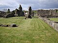
Sawley is a village and civil parish in the Borough of Ribble Valley in Lancashire, England. The population of the civil parish was 305 at the 2001 Census, [2] rising to 345 at the 2011 census. [1] It is situated north-east of Clitheroe, on the River Ribble. It was historically part of the West Riding of Yorkshire.

Contents

The parish adjoins the Ribble Valley parishes of Bolton-by-Bowland, Paythorne, Gisburn, Rimington, Downham, Chatburn and Grindleton.

History

Historically, Sawley fell under the Earl of Northumberland's Percy fee rather than being part of the neighbouring Lordship of Bowland. [3] Sawley Abbey, a ruined abbey of Cistercian monks, is in the village. The abbey was founded in 1147 and dissolved in 1536. [4] By the early 17th-century, the manor had come into the possession of James Hay, who in 1615 was created Lord Hay of Sawley, and later 1st Earl of Carlisle. [5]

Governance

Sawley was an extra-parochial area in the Staincliffe Wapentake of the West Riding of Yorkshire. This became a civil parish in 1858, forming part of the Bowland Rural District from 1894 to 1974. The civil parish previously had a detached area on the southern side of Gisburn with a smaller part of that parish on the western side of Sawley. In 1938 these areas were joined with the respective parishes. [6] It has since become part of the Lancashire borough of Ribble Valley. Sawley shares a parish council with two other parishes, Bolton-by-Bowland and Gisburn Forest. [7]

Along with Waddington, West Bradford and Grindleton, the parish forms the Waddington and West Bradford ward of Ribble Valley Borough Council. [8] [9]

See also

Related Research Articles

<span class="mw-page-title-main">Ribble Valley</span> Borough and non-metropolitan district in England

Ribble Valley is a local government district with borough status in Lancashire, England. Its council is based in Clitheroe, the largest town. The borough also includes the town of Longridge and numerous villages and surrounding rural areas. It is named after the River Ribble. Much of the district lies within the Forest of Bowland, a designated Area of Outstanding Natural Beauty.

<span class="mw-page-title-main">Newton-in-Bowland</span> Human settlement in England

Newton or Newton-in-Bowland is a village and civil parish in the Ribble Valley district, in the county of Lancashire, England, formerly known as Newton-on-Hodder. The civil parish had a population of 237 in 2001, according to the United Kingdom Census, increasing to 315 at the 2011 Census. The township covers almost 6,000 acres of the Forest of Bowland. Historically, the village is part of the West Riding of Yorkshire, but was transferred to Lancashire for administrative purposes on 1 April 1974, under the provisions of the Local Government Act 1972.

<span class="mw-page-title-main">Bashall Eaves</span> Village and civil parish in the Ribble Valley district of Lancashire, England

Bashall Eaves is a village and civil parish in the Ribble Valley district of Lancashire, England, about four miles (6 km) west of Clitheroe. The placename element eaves is Old English and refers to Bashall's location on the borders of the Forest of Bowland. Historically, the village is part of the West Riding of Yorkshire, but was transferred to Lancashire for administrative purposes on 1 April 1974, under the provisions of the Local Government Act 1972.

<span class="mw-page-title-main">Slaidburn</span> Human settlement in England

Slaidburn is a village and civil parish within the Ribble Valley district of Lancashire, England. The parish covers just over 5,000 acres of the Forest of Bowland.

<span class="mw-page-title-main">Bolton-by-Bowland</span> Human settlement in England

Bolton-by-Bowland is a village and civil parish in the Ribble Valley district of Lancashire, England. Before 1974, the village was part of Bowland Rural District in the West Riding of Yorkshire. According to the census of 2001, the parish had a population of just 498, rising marginally to 499 at the census of 2011.

<span class="mw-page-title-main">Bowland Forest Low</span> Human settlement in England

Bowland Forest Low is a civil parish in the Ribble Valley district of Lancashire, England, covering some 5,500 acres (22 km2) of the Forest of Bowland. According to the 2001 census, the parish had a population of 168, falling to 160 at the 2011 Census. The parish includes the hamlets of Whitewell and Cow Ark. From northwards clockwise, it borders the civil parishes of Newton, Bashall Eaves, Aighton, Bailey and Chaigley, Bowland-with-Leagram and Bowland Forest High. Before 1974, it formed part of Bowland Rural District in the West Riding of Yorkshire.

Bowland was a rural district in the West Riding of Yorkshire from 1894 to 1974. It was named after the Forest of Bowland, which it included.

<span class="mw-page-title-main">Chatburn</span> Village in Lancashire, England

Chatburn is a village, civil parish and electoral ward in the Ribble Valley, East Lancashire, England. The population of the civil parish at the 2011 census was 1,102. Situated in a hollow between two ridges north-east of Clitheroe, just off the A59 road, relatively near Pendle Hill south-east of the village. Lanehead quarry is situated to the West at the termination of Chatburn Old Road. Ribble lane at 240 above sea level leads down to the River Ribble North of the village, the top of Downham road being 150 feet higher.

<span class="mw-page-title-main">Waddington, Lancashire</span> Human settlement in England

Waddington is a small village, 2 miles (3 km) north-west of Clitheroe in the Ribble Valley, Lancashire, England. The population of the civil parish at the 2011 census was 1,028. Before the 1974 county boundary changes, Waddington fell just within the Bowland Rural District of the West Riding of Yorkshire. It covers approximately 2000 acres of the Forest of Bowland.

<span class="mw-page-title-main">Gisburn</span> Human settlement in England

Gisburn is a village and civil parish within the Ribble Valley borough of Lancashire, England. Historically within the West Riding of Yorkshire, it lies 8 miles (13 km) northeast of Clitheroe and 11 miles (18 km) west of Skipton. The civil parish had a population of 506, recorded in the 2001 census, increasing to 521 at the 2011 Census.

<span class="mw-page-title-main">West Bradford, Lancashire</span> Human settlement in England

West Bradford is a village and civil parish in Lancashire, England, 2.5 miles (4 km) north of Clitheroe. The population at the 2011 census was 788. It covers some 2000 acres of the Forest of Bowland. In Domesday, it is recorded as Bradeford and in the thirteenth century, Braford in Bouland. It was part of the West Riding of Yorkshire until 1974. "West Bradford" was introduced in the nineteenth century at the start of postal services to distinguish the village from the city of the same name.

<span class="mw-page-title-main">Grindleton</span> Human settlement in England

Grindleton is a village and civil parish in the Ribble Valley district of the English county of Lancashire, formerly in the West Riding of Yorkshire. Its 3,700 acres sit within the Forest of Bowland. The population of the civil ward taken at the 2011 census was 772.

<span class="mw-page-title-main">Newsholme, Lancashire</span> Human settlement in England

Newsholme is a small village and civil parish in the Ribble Valley, Lancashire, England, but lies within the historic West Riding of Yorkshire. According to the 2001 census, the parish had a population of 50, however the United Kingdom Census 2011 grouped the parish with Horton and Paythorne, giving a total of 253. Today it lies near the boundary with North Yorkshire on the A682, 4 miles (6 km) north of Barnoldswick and 12 miles (19 km) west of Skipton.

<span class="mw-page-title-main">Rimington</span> Human settlement in England

Rimington is a rural village and civil parish in the Ribble Valley, Lancashire, England. The population of the civil parish was 382 at the 2001 Census, however at the 2011 Census Middop was included with Rimington giving a total of 480. It is east of Clitheroe and south of the A59 road. The village consists of the hamlets of Howgill, Martin Top, Newby, and Stopper Lane, and is in the historic West Riding of Yorkshire.

<span class="mw-page-title-main">Paythorne</span> Village and civil parish in Lancashire, England

Paythorne is a small village and civil parish in Ribble Valley, Lancashire, England. It is situated alongside the River Ribble, north-east of Clitheroe, and on the boundary with North Yorkshire. Other parishes adjacent to Paythorne are Halton West, Nappa, Newsholme, Horton, Gisburn, Sawley, Bolton-by-Bowland and Gisburn Forest. The nearest town is Barnoldswick, situated 7 kilometres (4.3 mi) south-east of the village. Paythorne is on the edge of the Forest of Bowland Area of Outstanding Natural Beauty, although only a small area in the west of the parish is within the area's boundary. The Ribble Way long-distance walk passes through the village.

<span class="mw-page-title-main">Great Mitton</span> Human settlement in England

Great Mitton is a village and a civil parish in the Ribble Valley, Lancashire, England. It is separated from the civil parish of Little Mitton by the River Ribble, both lie about three miles from the town of Clitheroe. The combined population of both civil parishes at the 2011 census was 266. In total, Great and Little Mitton cover less than 2000 acres of the Forest of Bowland, making it the smallest township in the Forest. Historically, the village is part of the West Riding of Yorkshire, but was transferred to Lancashire for administrative purposes on 1 April 1974, under the provisions of the Local Government Act 1972.

<span class="mw-page-title-main">Horton, Lancashire</span> Village in Lancashire, England

Horton, historically known as Horton-in-Craven, is a village and a civil parish in the Ribble Valley district of the English county of Lancashire. Population details are now included in the civil parish of Newsholme. It is near the town of Barnoldswick. Horton has a place of worship, anciently called a chapelry or chapel of ease. For transport, there is the A59 nearby.

<span class="mw-page-title-main">Easington, Lancashire</span> Human settlement in England

Easington is a civil parish within the Ribble Valley district of Lancashire, England, with a population in 2001 of 52. The Census 2011 population details have been grouped with the parish of Slaidburn. Before 1974, it formed part of Bowland Rural District in the West Riding of Yorkshire. It covers just over 9000 acres.

<span class="mw-page-title-main">Gisburn Forest</span> Civil parish in Ribble Valley in Lancashire, England

Gisburn Forest is a civil parish in the Ribble Valley, in Lancashire, England. Mainly lying within the Forest of Bowland Area of Outstanding Natural Beauty, the parish includes the larger part of the village of Tosside and the hamlet of Grunsagill to the south. Historically, the parish lay within the West Riding of Yorkshire. It had a population of 151 at the 2011 Census.

<span class="mw-page-title-main">Middop</span> Human settlement in England

Middop is a rural hamlet and civil parish in Lancashire, England. It is in Ribble Valley district. Middop is near the villages of Rimington and Gisburn and approximately 8 miles (13 km) north-east of its post town, Clitheroe. In the 2001 United Kingdom census, Middop had a population of 43. Owing to the limited population from the 2011 Census details are included in the parish of Rimington.

References

  1. 1 2 UK Census (2011). "Local Area Report – Sawley Parish (1170215130)". Nomis. Office for National Statistics . Retrieved 8 February 2018.
  2. "Parish headcount" (PDF). Lancashire Parish Portal. Lancashire County Council. Archived from the original (PDF) on 10 December 2006. Retrieved 20 September 2008.
  3. The Lordship of Bowland http://www.forestofbowland.com/node/1864
  4. Historic England. "Sawley Abbey (1072099)". National Heritage List for England . Retrieved 20 September 2008.
  5. Whitaker, Thomas Dunham (1878), The history and antiquities of the deanery of Craven 3rd ed., Dodson (Leeds) and Cassell, Petter & Galpin (London), pp. 71–2, OCLC   504073084
  6. "Sawley CP/ExP through time". visionofbritain.org.uk. GB Historical GIS / University of Portsmouth. Retrieved 25 March 2016.
  7. "Bolton-by-Bowland, Gisburn Forest and Sawley Parish Council". Lancashire Parish Portal. Lancashire County Council. Archived from the original on 7 January 2006. Retrieved 20 September 2008.
  8. "Waddington and West Bradford". MARIO. Lancashire County Council. Retrieved 25 March 2016.
  9. "Waddington and West Bradford". Ordnance Survey Linked Data Platform. Ordnance Survey. Retrieved 25 March 2016.

Commons-logo.svg Media related to Sawley, Lancashire at Wikimedia Commons