Salesbury

Last updated

Salesbury
St Peter's Church, Salesbury - geograph.org.uk - 413160.jpg
St. Peter's Church
Location map United Kingdom Borough of Ribble Valley.svg
Red pog.svg
Salesbury
Shown within Ribble Valley
Lancashire UK location map.svg
Red pog.svg
Salesbury
Location within Lancashire
Population403 (Parish 2011) [1]
OS grid reference SD677335
Civil parish
  • Salesbury
District
Shire county
Region
Country England
Sovereign state United Kingdom
Post town Blackburn
Postcode district BB1
Dialling code 01254
Police Lancashire
Fire Lancashire
Ambulance North West
List of places
UK
England
Lancashire
53°47′49″N2°29′20″W / 53.797°N 2.489°W / 53.797; -2.489

Salesbury is a village and civil parish in Ribble Valley, located centrally in the county of Lancashire, England. [2] The B6245 road runs straight through the village providing transport links to towns such as Blackburn, Preston and Burnley. Salesbury lies less than 5 miles north of Blackburn and approximately 2 miles south of the River Ribble.

Contents

Copster Green is an area of houses a little north of Salesbury.

History

Salesbury is first recorded as a chapelry in the ancient parish of Blackburn but in 1866 it became a civil parish. [3] The Old English name of the village is 'Salebyry', dating from 1246 AD and 'Salewelle' dating from 1296 AD. This means 'burh by Sale Wheel' (burh is an Old English word meaning fortress). Sale Wheel is the name of a pool in the River Ribble where the river winds, contracts and foams over huge rocks and boulders within the channel and means "pool where willows grow". Wheel comes from the Anglo-Saxon word "weal" meaning a whirlpool. [4]

The church

Initially there was no church in Salesbury, so devout landowners of the village often had private chapels. It is known that Salesbury Old Hall and Showley Hall are two of the places that housed chapels. These could be attended by tenants and servants, but for baptisms, marriages and burials people went to nearby churches in Blackburn and Ribchester. These were the Parish Church of St. Mary in Blackburn and St Wilfrid's Church, Ribchester.

As the population of Salesbury grew towards the end of the 18th Century as a result in a boom in weaving, Viscount Bulkeley and other landowners raised the money to build a Chapelry. [5] St. Peter's Chapelry was built and consisted of a rectangular room with a bell, a chimney and a porch. It was consecrated on 8 September 1807 by the Lord Bishop of Chester. The Chapelry served its purpose for many years until 1848, when a report by the Rural Dean of Blackburn described the old church as 'having been originally very ill-built, and, in its present condition, inconvenient, uncouth, unchurchlike and ruinous.'. [5] The building was propped up, and church life went on as usual.

In 1873 a new vicar Rev. Peter Hopwood Hart arrived and set up a committee to raise money for a new church. The old chapelry was removed and a church was re-built in the same position. The church was finally consecrated on 29 June 1887. It was known as the Jubilee Church as it was built in the year of the Golden Jubilee of Queen Victoria. It was built in a 'late 14th-century Gothic' design by the architects Stones & Gradwell. [5]

The church is one of the main features in Salesbury. It boasts stained glass windows, an organ and a regular choir. [6] The church has a graveyard [7] which surrounds the church and includes spaces for both gravestones and cremation plaques. [8] The current incumbent is the Reverend Elizabeth M. McLean.

Population

1881–1961 census

Salesbury Total Population 1881-1961 Salesbury Total Population 1881-1961.jpg
Salesbury Total Population 1881–1961

The population of Salesbury has fluctuated throughout time. The 1881 census records the population to be 184 people. [9] This was spread over 1,150 acres of land and there were thought to be 58 houses. [10] The chapelry was so small that the residents post was sent to the local town of Blackburn [11] where it needed to be collected. As time went on the population reached a peak in the 1930s at 350 people and begun to plateau at around an average population of 300 around 1950. This did not follow the general trend of the UK as the 1930s mostly saw a low rate of population increase. Similarly as World War II ended and marriages boomed the population also increased in to peak in the 1960s. [12] This can be seen to a small extent on the graph but there was not a significant population change in Salesbury.

2001–2011 census

Much of the modern village of Salesbury lies within Clayton-le-Dale parish, the main centre of population in Salesbury being Copster Green. At the 2001 UK census, the parish had a population of 391, with 1,142 in Clayton-le-Dale, [13] whereas the 2011 UK census recorded populations of 403 and 1,128 respectively. [1] [14] Clayton-le-Dale is situated further down the same road and is approximately the same size if a little bigger than Salesbury, so it could be interpreted that by halving the figure a rough estimate of the population could be achieved. In the same area there were 624 houses recorded which by the same logic still shows a significant increase from the early figures of 58 houses. This increase could be due to the people who are tempted away from big towns and cities as a result of the 'rural idyll'

Employment

1881 census

In the census carried out in 1881 55% of men were employed either in agriculture (29%) or working with mineral substances (26%). These high levels of manual labour are typical of the time. At the other end of the scale the least popular forms of employment were as professionals (2%), as workers in food and lodging (3%) or in transport and communication (3%). As it could be expected the majority of women worked in domestic services or offices (22%) or in textiles and fabrics (22%). [15] Many women were employed by the weaving trade, this was also responsible for a boom in the population towards the end of the 18th century as the craft became more popular.

2001 census

The United Kingdom Census 2001 shows a change in the types on employment in the village. The two main forms of employment are manufacturing (17%) and wholesale and retail trade (18%). It is clear that manufacturing can still be seen as a form of manual labour suggesting little change. But the increase in employment in retail and trade follows with the retail trends of the 21st century. In contrast, previously popular employment such as Fishing, Mining and quarrying all currently employ no one in the village. [16] This shows a shift from primary employment to secondary and tertiary forms of employment.

Amenities

There are few local amenities in the village of Salesbury as the small size of the settlement and the proximity to Blackburn means that residents can easily access services elsewhere. The village's amenities include; a public house, a memorial hall, a primary school, a cricket club and of course the church.

The Bonny Inn

The Bonny Inn pub is situated in the southern part of the village on Ribchester road. It is described as a 'traditional family pub' according to The Good Pub Guide. [17]

The Memorial Hall

Salesbury Memorial Hall Salesbury Memorial Hall - geograph.org.uk - 413163.jpg
Salesbury Memorial Hall

Salesbury Memorial Hall is located on Ribchester Road in Salesbury. It is intended for the use of the inhabitants of the village, This includes meetings, classes and leisure activities. Last years income was £13,552 whilst the expenditure was £10,941 leaving a profit of £2.611 for the hall. [18] The grounds surrounding and near to the Memorial Hall belong to the Wilpshire Wanderers under 5 to under 10 football teams. The ground opened in 2002 by former Blackburn and England favourite Ronnie Clayton (footballer). Ronnie was also the Honorary President of Wilpshire Wanderers Football Club until he died in 2010. [19]

Salesbury School

Salesbury school is a mixed primary school which caters for children from ages 3–11. The school has 9 classes in total not including the nursery, [20] this adds up to a total of 275 full-time pupils and 45 part-time pupils. [21]

Salesbury Cricket Club

The cricket club (Salesbury CC) was founded in 1906, and the team initially played in the Blackburn Sunday school league. It boasts both junior and adult sections. The junior section consists of U9, U11, U13, U15 and U18 teams, and is credited with E.C.B. Clubmark Status, This shows the high quality and standard of the club. [22] There are three adult teams, 1st, 2nd and 3rd's.

See also

Related Research Articles

<span class="mw-page-title-main">Ribble Valley</span> Borough and non-metropolitan district in England

Ribble Valley is a local government district with borough status in Lancashire, England. Its council is based in Clitheroe, the largest town. The borough also includes the town of Longridge and numerous villages and surrounding rural areas. It is named after the River Ribble. Much of the district lies within the Forest of Bowland, a designated Area of Outstanding Natural Beauty.

<span class="mw-page-title-main">River Ribble</span> River in North Yorkshire and Lancashire, England

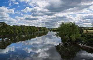
The River Ribble runs through North Yorkshire and Lancashire in Northern England. It starts close to the Ribblehead Viaduct in North Yorkshire, and is one of the few that start in the Yorkshire Dales and flow westwards towards the Irish Sea.

<span class="mw-page-title-main">Blackburn Hundred</span> Former sub-division of Lancashire, UK

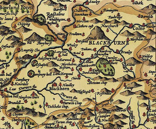
Blackburn Hundred is a historic sub-division of the county of Lancashire, in northern England. Its chief town was Blackburn, in the southwest of the hundred. It covered an area similar to modern East Lancashire, including the current districts of Ribble Valley, Pendle, Burnley, Rossendale, Hyndburn, Blackburn with Darwen, and South Ribble.

<span class="mw-page-title-main">Ribchester</span> Human settlement in England

Ribchester is a village and civil parish within the Ribble Valley district of Lancashire, England. It lies on the banks of the River Ribble, six miles (10 km) northwest of Blackburn and twelve miles (19 km) east of Preston.

<span class="mw-page-title-main">Ramsgreave and Wilpshire railway station</span> Railway station in Lancashire, England

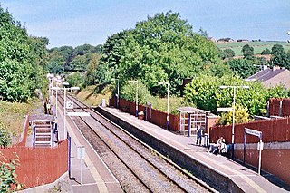
Ramsgreave and Wilpshire is a railway station on the Ribble Valley Line that serves the villages/suburbs of Ramsgreave and Wilpshire, just north of Blackburn in Lancashire, England. The station is 2+34 miles (4.4 km) north of Blackburn railway station.

<span class="mw-page-title-main">Ribble Valley (UK Parliament constituency)</span> Parliamentary constituency in the United Kingdom, 1983 onwards

Ribble Valley is a constituency in Lancashire represented in the House of Commons of the UK Parliament since 1992 by Nigel Evans, a Conservative. Evans has served as a Deputy Speaker of the House of Commons and Second Deputy Chairman of Ways and Means since January 2020; he previously served as First Deputy Chairman of Ways and Means from 2010 to 2013.

<span class="mw-page-title-main">Bamber Bridge</span> Human settlement in England

Bamber Bridge is a large village in Lancashire, England, 3 miles (5 km) south-east of Preston, in the borough of South Ribble. The name derives from the Old English "bēam" and "brycg", which probably means "tree-trunk bridge". People who live in Bamber Bridge like to be known as Briggers.
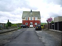
<span class="mw-page-title-main">Bowland Forest Low</span> Human settlement in England

Bowland Forest Low is a civil parish in the Ribble Valley district of Lancashire, England, covering some 5,500 acres (22 km2) of the Forest of Bowland. According to the 2001 census, the parish had a population of 168, falling to 160 at the 2011 Census. The parish includes the hamlets of Whitewell and Cow Ark. From northwards clockwise, it borders the civil parishes of Newton, Bashall Eaves, Aighton, Bailey and Chaigley, Bowland-with-Leagram and Bowland Forest High. Before 1974, it formed part of Bowland Rural District in the West Riding of Yorkshire.

<span class="mw-page-title-main">Samlesbury</span> Human settlement in England

Samlesbury is a village and civil parish in South Ribble, Lancashire, England. Samlesbury Hall, a historic house, is in the village, as is Samlesbury Aerodrome and a large modern brewery owned by Anheuser-Busch InBev. The population at the 2011 census was 1,206.

Blackburn was a large parish in Lancashire, England. The parish had numerous townships and chapelries, which were administered separately from the core Blackburn area, and became recognised as separate civil parishes in 1866. The parish formed part of the Blackburn hundred.

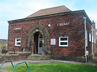
Ramsgreave is a civil parish in the Ribble Valley district of Lancashire, England. The parish is located on the northern edge of Blackburn although it is just outside the Blackburn with Darwen unitary district, and although the south and east of the parish is suburban, the parish also includes a rural area including Ribble Valley's only greenbelt land. The population of the civil parish taken at the 2011 census was 817. It is served by Ramsgreave and Wilpshire railway station. There are approximately 6 miles of footpaths and 2.5 miles of road within the parish.

<span class="mw-page-title-main">Gisburn</span> Human settlement in England

Gisburn is a village and civil parish within the Ribble Valley borough of Lancashire, England. Historically within the West Riding of Yorkshire, it lies 8 miles (13 km) northeast of Clitheroe and 11 miles (18 km) west of Skipton. The civil parish had a population of 506, recorded in the 2001 census, increasing to 521 at the 2011 Census.

Dutton is a civil parish in the Borough of Ribble Valley in the English county of Lancashire, its principal settlement being the hamlet of Lower Dutton. The population of the civil parish at the 2011 census was 238.

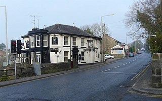
Clayton-le-Dale is a village and civil parish situated on the A59 road near Blackburn, in Lancashire, England. The population of the civil parish as of the 2011 census was 1,228. The village is in the Ribble Valley local government district.

<span class="mw-page-title-main">Wilpshire</span> Human settlement in England

Wilpshire is a village and civil parish in the county of Lancashire, England. It is 2.5 miles (4.0 km) north of Blackburn, and forms part of the town's urban area, although it is in the Ribble Valley local government district. In the 2001 United Kingdom census, the parish had a population of 2,569, increasing to 2,582 at the 2011 Census.

<span class="mw-page-title-main">Osbaldeston</span> Human settlement in England

Osbaldeston is a village and civil parish in Lancashire, England about 3+14 miles (5.2 km) north-west of Blackburn and 7 miles (11.3 km) east of Preston. The population of the civil parish as taken at the 2011 census was 185.

<span class="mw-page-title-main">Royal Lancashire Show</span>

The Royal Lancashire Show (RLS) is an agricultural show which takes place every year at different locations throughout the historical county boundaries of Lancashire in Northern England. The show is organised by the Royal Lancashire Agricultural Society (RLAS) and is one of Britain's oldest agricultural shows, first taking place in 1767.

<span class="mw-page-title-main">Great Mitton</span> Human settlement in England

Great Mitton is a village and a civil parish in the Ribble Valley, Lancashire, England. It is separated from the civil parish of Little Mitton by the River Ribble, both lie about three miles from the town of Clitheroe. The combined population of both civil parishes at the 2011 census was 266. In total, Great and Little Mitton cover less than 2000 acres of the Forest of Bowland, making it the smallest township in the Forest. Historically, the village is part of the West Riding of Yorkshire, but was transferred to Lancashire for administrative purposes on 1 April 1974, under the provisions of the Local Government Act 1972.

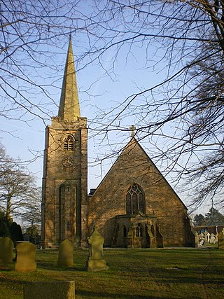
Salesbury is a civil parish in Ribble Valley, Lancashire, England. It contains four listed buildings that are recorded in the National Heritage List for England. All of the listed buildings are designated at Grade II, the lowest of the three grades, which is applied to "buildings of national importance and special interest". The parish contains the village of Salesbury and the residential area of Copster Green, and is otherwise rural. The listed buildings consist of a farmhouse with an attached stable, and two houses, one with a sundial base in the grounds.

References

  1. 1 2 UK Census (2011). "Local Area Report – Salesbury Parish (1170215129)". Nomis. Office for National Statistics . Retrieved 2 February 2018.
  2. "Salesbury, Lancashire". Eyez And Earz. Archived from the original on 8 July 2012. Retrieved 1 April 2012.
  3. "Salesbury CP/Ch through time". visionofbritain.org.uk. GB Historical GIS / University of Portsmouth. Retrieved 5 April 2016.
  4. Ekwall, Eilert (1922). The place-names of Lancashire. Manchester University Press. p. 70. Retrieved 5 April 2016.
  5. 1 2 3 "Family SearchSalesbury, Lancashire". Family Search- Salesbury, Lancashire. Retrieved 9 October 2016.
  6. "The Church of England". The Church of England. Retrieved 9 October 2016.
  7. "Genuki". Genuki. Retrieved 9 October 2016.
  8. "Brent Stevenson Memorials". Brent Stevenson Memorials. Retrieved 9 October 2016.
  9. "Salesbury CP/Ch, Population". A Vision Of Britain Through Time. Retrieved 9 October 2016.
  10. "Salesbury CP/Ch, Housing". A Vision Of Britain Through Time. Retrieved 9 October 2016.
  11. "Salesbury". GENUKI. Retrieved 9 October 2016.
  12. "United Kingdom, Population Growth". Encyclopædia Britannica. Retrieved 1 April 2012.
  13. "Parish headcount" (PDF). Lancashire County Council. Archived from the original (PDF) on 10 December 2006. Retrieved 27 December 2008.
  14. UK Census (2011). "Local Area Report – Clayton-le-Dale Parish (1170215102)". Nomis. Office for National Statistics. Retrieved 2 February 2018.
  15. "St. A Vision of Britain Through Time". A Vision of Britain Through Time. Retrieved 9 October 2016.
  16. "2001 Census, Neighbourhood Statistics Industry of Employment". 2001 Census, Neighbourhood Statistics – Industry of Employment. Retrieved 9 October 2016.
  17. "The Good Pub Guide". The Good Pub Guide. Retrieved 9 October 2016.
  18. "Charities Aid Foundation". Charities Aid Foundation. Retrieved 1 February 2012.
  19. "Wilpshire Wanderers". Wilpshire Wanderers. Retrieved 9 October 2016.
  20. "Salesbury School". Salesbury School. Retrieved 9 October 2016.
  21. "Department of Education". Department of Education. Retrieved 1 April 2012.
  22. "Salesbury Cricket Club". Salesbury Cricket Club. Archived from the original on 13 July 2012. Retrieved 9 October 2016.