Pendleton, Lancashire

Last updated

Pendleton
Pendleton.jpg
Pendleton
Location map United Kingdom Borough of Ribble Valley.svg
Red pog.svg
Pendleton
Shown within Ribble Valley
Lancashire UK location map.svg
Red pog.svg
Pendleton
Location within Lancashire
Population203 (2001) [1]
OS grid reference SD756395
Civil parish
  • Pendleton
District
Shire county
Region
Country England
Sovereign state United Kingdom
Post town CLITHEROE
Postcode district BB7
Dialling code 01200
Police Lancashire
Fire Lancashire
Ambulance North West
UK Parliament
List of places
UK
England
Lancashire
53°51′04″N2°22′16″W / 53.851°N 2.371°W / 53.851; -2.371

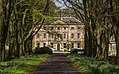
Pendleton is a small village and civil parish in Ribble Valley, within the county of Lancashire, England. It is close to the towns of Whalley and Clitheroe. The parish lies on the north west side of Pendle Hill below the Nick o' Pendle. The village is just off the A59, Liverpool to York main road, since the construction of the Clitheroe By-Pass. Older roads through the parish include one from Clitheroe to Whalley which passes through the Standen area and another to Burnley which passes Pendleton Hall. [2]

Contents

Pendleton Brook runs down the centre of Main Street in the village. The village pub, the Swan with Two Necks, won the Campaign for Real Ale's (CAMRA) national pub of the year award in 2013. [3]

According to the 2001 census, the parish had a population of 203; however, the United Kingdom Census 2011 grouped the parish with Mearley and Worston (2001 pop. 25 and 76), giving a total of 349. [1] [4] [5]

The parish adjoins the other Ribble Valley parishes of Clitheroe, Mearley, Sabden, Wiswell, Barrow and Little Mitton. Higher areas of the parish, west of the village, are part of the Forest of Bowland Area of Outstanding Natural Beauty (AONB). [6]

History

The brief details of the Blackburnshire hundred in the Domesday survey, mention Pendleton with King Edward holding half a hide of land here. [7] [2]

Wymondhouses (an old farm in the south of the parish) was purchased in 1667 by the Nonconformist preacher Thomas Jollie. He had a meeting-place licensed in 1672, later building a chapel that was still in-use until the 1860s. [2] [8]

Pendleton also has an interesting history related to traditional folk customs and the witchcraft persecutions. A book was written on this subject entitled The Pendle Witches by William Harrison Ainsworth, published 1849. Doreen McGlashan, born Doreen Wilson, a Pendleton native, stated that as a child in the 1920s there was frequent talk of witches and witchcraft in the village, and that she and her siblings were kept indoors on certain Saturdays because of "witches Sabbaths" happening in the town on those days. She also recounts large May Day celebrations in her youth which included dancing around a maypole, and states that as a girl she specifically remembers "pretty girls" often being suspected of witchcraft by the villagers.[ citation needed ]

Governance

Pendleton was once a township in the ancient parish of Whalley. This became a civil parish in 1866, forming part of the Clitheroe Rural District from 1894. Parts of the parish transferred to Sabden on its creation in 1904, [lower-alpha 1] however the area around Coldcoats was added in 1935. [10] Since 1974 it has formed part of the Borough of Ribble Valley.

Along with Wiswell, Barrow (since 2015), Mearley and Worston, the parish forms the Wiswell and Pendleton ward of Ribble Valley Borough Council. [5] [11]

Notable people

See also

Related Research Articles

<span class="mw-page-title-main">Read, Lancashire</span> Human settlement in England

Read is a village in Lancashire 5 miles west northwest of Burnley and 2 miles east of Whalley. It is on the A671 which is the main road between Burnley and Clitheroe. The population of the civil parish as taken at the 2011 census was 1,419.

<span class="mw-page-title-main">Forest of Bowland</span> Upland conservation area in Lancashire, England

The Forest of Bowland, also known as the Bowland Fells and formerly the Chase of Bowland, is an area of gritstone fells, deep valleys and peat moorland, mostly in north-east Lancashire, England, with a small part in North Yorkshire. It is a western outlier of the Pennines.

<span class="mw-page-title-main">Ribble Valley</span> Borough in England

Ribble Valley is a local government district with borough status within the non-metropolitan county of Lancashire, England. The total population of the non-metropolitan district at the 2011 Census was 57,132. Its council is based in Clitheroe. Other places include Whalley, Longridge and Ribchester. The area is named after the River Ribble, which flows in its final stages towards its estuary near the Preston. The area is popular with tourists who enjoy the area's natural unspoilt beauty, much of which lies within the Forest of Bowland.

<span class="mw-page-title-main">Blackburn Hundred</span> Former sub-division of Lancashire, UK

Blackburn Hundred is a historic sub-division of the county of Lancashire, in northern England. Its chief town was Blackburn, in the southwest of the hundred. It covered an area similar to modern East Lancashire, including the current districts of Ribble Valley, Pendle, Burnley, Rossendale, Hyndburn, Blackburn with Darwen, and South Ribble.

<span class="mw-page-title-main">Higham, Lancashire</span> Human settlement in England

Higham is a village in the Borough of Pendle in Lancashire, England, south of Pendle Hill. The civil parish is named Higham with West Close Booth. The village is 2 miles (3 km) north-east of Padiham and about 4 miles (6 km) south-west of Nelson along the A6068 road.

<span class="mw-page-title-main">Pendle Hill</span> Hill in Lancashire, England

Pendle Hill is in the east of Lancashire, England, near the towns of Burnley, Nelson, Colne, Brierfield, Clitheroe and Padiham. Its summit is 557 metres (1,827 ft) above mean sea level. It gives its name to the Borough of Pendle. It is an isolated hill in the Pennines, separated from the South Pennines to the east, the Bowland Fells to the northwest, and the West Pennine Moors to the south. It is included in a detached part of the Forest of Bowland Area of Outstanding Natural Beauty.

<span class="mw-page-title-main">Barley-with-Wheatley Booth</span> Human settlement in England

Barley-with-Wheatley Booth is a civil parish in the Pendle district of Lancashire, England. It has a population of 298, and contains the village of Barley and the hamlet of White Hough or Whitehough. To the west of Barley is Pendle Hill; its summit, at 557 metres (1,827 ft), is within the parish.

<span class="mw-page-title-main">Worston</span> Human settlement in England

Worston is a small linear village and civil parish in Lancashire, England. The village is north-west of Pendle Hill, east of Clitheroe, and is in the Ribble Valley district. As it is only a small village, with a population of 76 at the 2001 census, it has no parish council, but instead has a parish meeting. The parish meeting is shared with Mearley. From the 2011 Census population information for both Mearley and Worston is included within the civil parish of Pendleton.

<span class="mw-page-title-main">Pendleton Brook</span> River in Lancashire, England

Pendleton Brook is a small river in Lancashire. The brook rises on Pendleton Moor and flows through the village of Pendleton, travelling north west to Higher Standen, then west past Standen Hall. From there, Pendleton Brook flows south of Clitheroe before meeting the River Ribble near Siddows.

<span class="mw-page-title-main">Clitheroe Castle</span> Medieval castle in Lancashire, England

Clitheroe Castle is a ruined early medieval castle in Clitheroe in Lancashire, England. It was the caput of the Honour of Clitheroe, a vast estate stretching along the western side of the Pennines.

<span class="mw-page-title-main">Chatburn</span> Human settlement in England

Chatburn is a village, civil parish and electoral ward in the Ribble Valley, East Lancashire, England. The population of the civil parish at the 2011 census was 1,102. Situated in a hollow between two ridges north-east of Clitheroe, just off the A59 road, relatively near Pendle Hill south-east of the village. Lanehead quarry is situated to the West at the termination of Chatburn Old Road. Ribble lane at 240 above sea level leads down to the River Ribble North of the village, the top of Downham road being 150 feet higher.

<span class="mw-page-title-main">Sabden</span> Human settlement in England

Sabden is a village and civil parish in the Ribble Valley, Lancashire, England. Sabden is located south of Pendle Hill, in a valley about three miles north west of Padiham. The parish covers 2,450.9 acres (991.85 ha), of which 103.2 acres (41.75 ha) is occupied by the village. It lies in the Forest of Pendle section of the Forest of Bowland Area of Outstanding Natural Beauty.

<span class="mw-page-title-main">Wiswell</span> Human settlement in England

Wiswell is a small village and civil parish in the Ribble Valley, Lancashire, England, close to Whalley and Clitheroe at the foot of Wiswell Moor.

<span class="mw-page-title-main">Barrow, Lancashire</span> Village and civil parish in Lancashire, England

Barrow is a village and civil parish in the Ribble Valley district in Lancashire, England, situated between Whalley and Clitheroe and bypassed by the A59. It has a primary school, a Chinese takeaway and two parks. The village is well served by local bus routes, giving direct access to many parts of Lancashire. New development has taken place in the area between Whalley Road and the bypass.

<span class="mw-page-title-main">Goldshaw Booth</span> Human settlement in England

Goldshaw Booth is a civil parish in the Pendle district of Lancashire, England. It has a population of 248, and contains the village of Newchurch in Pendle and the hamlets of Spen Brook and Sabden Fold. Pendle Hill lies to the north.

<span class="mw-page-title-main">Downham, Lancashire</span> Human settlement in England

Downham is a village and civil parish in Lancashire, England. It is in the Ribble Valley district and at the United Kingdom 2001 census had a population of 156. The 2011 Census includes neighbouring Twiston giving a total for both parishes of 214. The village is on the north side of Pendle Hill off the A59 road about 3 miles (4.8 km) from Clitheroe. Much of the parish, including the village is part of the Forest of Bowland Area of Outstanding Natural Beauty (AONB). It adjoins the Ribble Valley parishes of Rimington, Twiston, Worston, Chatburn and Sawley, and the Pendle parish of Barley-with-Wheatley Booth.

<span class="mw-page-title-main">Mearley</span> Human settlement in England

Mearley is a civil parish in Lancashire, England. The parish is north-west of Pendle Hill, east of Clitheroe, and is in the Ribble Valley district. It is a small parish with no villages or hamlets and a population of 25, the second smallest in Lancashire, at the 2001 census. It has no parish council, but instead has a parish meeting shared with neighbouring Worston. From the 2011 Census population information for both Mearley and Worston is included within the civil parish of Pendleton, giving a total of 349. The eastern part of the parish is included in the Pendle outlier section of the Forest of Bowland Area of Outstanding Natural Beauty (AONB).

Twiston is a village and a civil parish in the Ribble Valley District, in the English county of Lancashire. It is near the town of Clitheroe and the village of Downham. The parish is part of the Forest of Bowland Area of Outstanding Natural Beauty (AONB). It adjoins the Ribble Valley parishes of Downham and Rimington, and the Pendle parish of Barley-with-Wheatley Booth.

<span class="mw-page-title-main">Forest of Pendle</span> Hilly area in eastern Lancashire, England

The Forest of Pendle is the name given to an area of hilly landscape to the east of Pendle Hill in eastern Lancashire, roughly defining the watershed between the River Ribble and its tributary the River Calder. The forest is not identical to the modern local government district of Pendle, which is larger. And in fact the modern version of the forest has come to contain areas to the north and east of Pendle Hill which are partly in the district of Ribble Valley.

<span class="mw-page-title-main">Mearley Brook</span> River in Lancashire, England

Mearley Brook is a minor river in Lancashire, England. It is approximately 4.5 miles (7.2 km) long and has a catchment area of 8.79 square miles (22.77 km2).

References

Notes

  1. The old township shared a boundary with Read at Sabden Brook. [9]

Citations

  1. 1 2 "Parish headcount" (PDF). Lancashire County Council. Archived from the original (PDF) on 10 December 2006. Retrieved 27 December 2008.
  2. 1 2 3 4 Farrer and Brownbill 1911, pp. 392–396
  3. Rebecca Smithers (19 August 2015). "Camra crowns Swan with Two Necks in Lancashire national pub of the year". The Guardian. London.
  4. UK Census (2011). "Local Area Report – Pendleton Parish (1170215123)". Nomis. Office for National Statistics . Retrieved 8 February 2018.
  5. 1 2 "Wards and parishes map". MARIO. Lancashire County Council. Retrieved 26 February 2018.
  6. Forest of Bowland map (Map). forestofbowland.com. Lancashire County Council.
  7. "Domesday Book Online". domesdaybook.co.uk. Retrieved 18 August 2015.
  8. Historic England, "No. 2 Wymondhouses, Pendleton (1165082)", National Heritage List for England, retrieved 18 August 2015
  9. Lancashire and Furness (Map) (1st ed.). 1 : 10,560. County Series. Ordnance Survey. 1848.
  10. "Pendleton Tn/CP through time". visionofbritain.org.uk. GB Historical GIS / University of Portsmouth. Retrieved 18 August 2015.
  11. "Wiswell and Pendleton". Ordnance Survey Linked Data Platform. Ordnance Survey. Retrieved 26 March 2016.

Bibliography