Twiston

Last updated

Twiston
Location map United Kingdom Borough of Ribble Valley.svg
Red pog.svg
Twiston
Shown within Ribble Valley
Lancashire UK location map.svg
Red pog.svg
Twiston
Location within Lancashire
Population64  (2001 Census) [1]
OS grid reference SD813438
Civil parish
  • Twiston
District
Shire county
Region
Country England
Sovereign state United Kingdom
Post town CLITHEROE
Postcode district BB7
Dialling code 01200
Police Lancashire
Fire Lancashire
Ambulance North West
UK Parliament
List of places
UK
England
Lancashire
53°53′27″N2°17′06″W / 53.8907°N 2.2851°W / 53.8907; -2.2851 Coordinates: 53°53′27″N2°17′06″W / 53.8907°N 2.2851°W / 53.8907; -2.2851

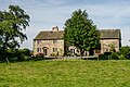
Twiston is a village and a civil parish in the Ribble Valley District, in the English county of Lancashire. It is near the town of Clitheroe and the village of Downham (in whose parish the population of Twiston is now included). The parish is part of the Forest of Bowland Area of Outstanding Natural Beauty (AONB). [2] It adjoins the Ribble Valley parishes of Downham and Rimington, and the Pendle parish of Barley-with-Wheatley Booth.

Contents

Twiston was once a township in the ancient parish of Whalley. This became a civil parish in 1866, forming part of the Clitheroe Rural District from 1894 till 1974. [3]

Along with Chatburn and Downham, the parish makes up the Chatburn ward of Ribble Valley Borough Council. [4] [5]

See also

Related Research Articles

Forest of Bowland area in northeast Lancashire, England

The Forest of Bowland, also known as the Bowland Fells, is an area of barren gritstone fells, deep valleys and peat moorland, mostly in north-east Lancashire, England with a small part in North Yorkshire. It is a western spur of the Pennines and was once described as the "Switzerland of England".

Clitheroe Town in England

Clitheroe is a town and civil parish in the Borough of Ribble Valley in Lancashire, England, approximately 34 miles (55 km) northwest of Manchester. It is near the Forest of Bowland, and is often used as a base for tourists visiting the area. In 2018, Clitheroe Built Up Area had an estimated population of 16,279.

Ribble Valley Borough in England

Ribble Valley is a local government district with borough status within the non-metropolitan county of Lancashire, England. The total population of the non-metropolitan district at the 2011 Census was 57,132. Its council is based in Clitheroe. Other places include Whalley, Longridge and Ribchester. The area is so called due to the River Ribble which flows in its final stages towards its estuary near Preston. The area is popular with tourists who enjoy the area's natural unspoilt beauty, much of which lies within the Forest of Bowland.

Blackburn Hundred

Blackburn Hundred is a historic sub-division of the county of Lancashire, in northern England. Its chief town was Blackburn, in the southwest of the hundred. It covered an area similar to modern East Lancashire, including the current districts of Ribble Valley, Pendle, Burnley, Rossendale, Hyndburn, Blackburn with Darwen, and South Ribble.

Higham, Lancashire Human settlement in England

Higham is a village in the Borough of Pendle in Lancashire, England, south of Pendle Hill. The civil parish is named Higham with West Close Booth. The village is 2 miles (3 km) northeast of Padiham and about 4 miles (6 km) southwest of Nelson along the A6068 road.

Blacko Human settlement in England

Blacko is a village and civil parish in the Pendle district of Lancashire, England. Before local government reorganisation in 1974 the village lay on the border with the West Riding of Yorkshire. The parish has a population of 672. The village is on the old turnpike road from Nelson to Gisburn (A682). The village enjoys views towards Boulsworth Hill to its southeast, the former cotton town of Nelson, about two miles to its south and Pendle Hill to its west across the valley of Pendle Water.

Barley-with-Wheatley Booth Human settlement in England

Barley-with-Wheatley Booth is a civil parish in the Pendle district of Lancashire, England. It has a population of 298, and contains the village of Barley and the hamlet of White Hough or Whitehough. To the west of Barley is Pendle Hill; its summit, at 557 metres (1,827 ft), is within the parish.

Worston Human settlement in England

Worston is a small linear village and civil parish in Lancashire, England. The village is north-west of Pendle Hill, east of Clitheroe, and is in the Ribble Valley district. As it is only a small village, with a population of 76 at the 2001 census, it has no parish council, but instead has a parish meeting. The parish meeting is shared with Mearley, a small parish south of Worston with no villages or hamlets and a population of 25, the second smallest in Lancashire. From the 2011 Census population information for both Mearley and Worston is included within the civil parish of Pendleton.

Chatburn Human settlement in England

Chatburn is a village, civil parish and electoral ward in the Ribble Valley, East Lancashire, England. The population of the civil parish at the 2011 census was 1,102. It is situated in a hollow between two ridges north-east of Clitheroe, just off the A59 road. It lies near Pendle Hill, which is to the east of the village. The River Ribble flows to the west of the town. The town is approximately 400 feet above sea level.

Sabden Human settlement in England

Sabden is a medium-to-large village and civil parish in the Ribble Valley, Lancashire, England. Sabden is located south of Pendle Hill, in a valley about three miles north west of Padiham. The parish covers 2,450.9 acres (991.85 ha), of which 103.2 acres (41.75 ha) is occupied by the village. It lies in the Forest of Pendle section of the Forest of Bowland Area of Outstanding Natural Beauty.

Gisburn Human settlement in England

Gisburn is a village and civil parish within the Ribble Valley borough of Lancashire, England. Historically within the West Riding of Yorkshire, it lies 8 miles (13 km) northeast of Clitheroe and 11 miles (18 km) west of Skipton. The civil parish had a population of 506, recorded in the 2001 census, increasing to 521 at the 2011 Census.

Wiswell Human settlement in England

Wiswell is a small village and civil parish in the Ribble Valley, Lancashire, England, close to Whalley and Clitheroe at the foot of Wiswell Moor.

West Bradford, Lancashire Human settlement in England

West Bradford is a village and civil parish in Lancashire, England, 27 miles (43 km) west of the larger city of Bradford, West Yorkshire and 2.5 miles (4 km) north of Clitheroe. The population of the civil parish taken at the 2011 census was 788. It covers some 2000 acres of the Forest of Bowland. In Domesday, it is recorded as Bradeford and in the thirteenth century, Braford in Bouland. It was part of the West Riding of Yorkshire until 1974. "West Bradford" was introduced in the nineteenth century at the time of the introduction of postal services to help distinguish the village from its larger eastern neighbour of the same name.

Pendleton, Lancashire Human settlement in England

Pendleton is a small village and civil parish in Ribble Valley, within the county of Lancashire, England. It is close to the towns of Whalley and Clitheroe. The parish lies on the north west side of Pendle Hill below the Nick o' Pendle. The village is just off the A59, Liverpool to York main road, since the construction of the Clitheroe By-Pass. Older roads through the parish include one from Clitheroe to Whalley which passes through the Standen area and another to Burnley which passes Pendleton Hall.

Goldshaw Booth Human settlement in England

Goldshaw Booth is a civil parish in the Pendle district of Lancashire, England. It has a population of 248, and contains the village of Newchurch in Pendle and the hamlets of Spen Brook and Sabden Fold. Pendle Hill lies to the north.

Downham, Lancashire Human settlement in England

Downham is a village and civil parish in Lancashire, England. It is in the Ribble Valley district and at the United Kingdom 2001 census had a population of 156. The 2011 Census includes neighbouring Twiston giving a total for both parishes of 214. The village is on the north side of Pendle Hill off the A59 road about 3 miles (4.8 km) from Clitheroe. Much of the parish, including the village is part of the Forest of Bowland Area of Outstanding Natural Beauty (AONB). It adjoins the Ribble Valley parishes of Rimington, Twiston, Worston, Chatburn and Sawley, and the Pendle parish of Barley-with-Wheatley Booth.

Rimington Human settlement in England

Rimington is a rural village and civil parish in the Ribble Valley, Lancashire, England. The population of the civil parish was 382 at the 2001 Census, however at the 2011 Census Middop was included with Rimington giving a total of 480. It is east of Clitheroe and south of the A59 road. The village consists of the hamlets of Howgill, Martin Top, Newby, and Stopper Lane, and was formerly in the West Riding of Yorkshire.

Sawley, Lancashire Human settlement in England

Sawley is a village and civil parish in the Borough of Ribble Valley in Lancashire, England. The population of the civil parish was 305 at the 2001 Census, rising to 345 at the 2011 census. It is situated north-east of Clitheroe, on the River Ribble. It was historically part of the West Riding of Yorkshire.

Middop Human settlement in England

Middop is a rural hamlet and civil parish in Lancashire, England. It is in Ribble Valley district. Middop is near the villages of Rimington and Gisburn and approximately 8 miles (13 km) north-east of its post town, Clitheroe. In the 2001 United Kingdom census, Middop had a population of 43. Owing to the limited population from the 2011 Census details are included in the parish of Rimington.

Forest of Pendle

The Forest of Pendle is the name given to an area of hilly landscape to the east of Pendle Hill in eastern Lancashire, roughly defining the watershed between the River Ribble and its tributary the River Calder. The forest is not identical to the modern local government district of Pendle, which is larger. And in fact the modern version of the forest has come to contain areas to the north and east of Pendle Hill which are partly in the district of Ribble Valley.

References

  1. Office for National Statistics : Census 2001 : Parish Headcounts : Ribble Valley Retrieved 31 July 2010
  2. Forest of Bowland map (Map). forestofbowland.com. Lancashire County Council.
  3. "Twiston Tn/CP through time". visionofbritain.org.uk. GB Historical GIS / University of Portsmouth. Retrieved 4 January 2016.
  4. "Chatburn". MARIO. Lancashire County Council. Retrieved 25 March 2016.
  5. "Chatburn". Ordnance Survey Linked Data Platform. Ordnance Survey. Retrieved 25 March 2016.
  6. Historic England. "Twiston lime kiln and associated tramway 250m east of Twiston Mill (1021016)". National Heritage List for England . Retrieved 17 March 2016.

Commons-logo.svg Media related to Twiston at Wikimedia Commons