Loughrigg Fell

Last updated

Loughrigg Fell
Loughrigg.jpg
Highest point
Elevation 335 m (1,099 ft)
Prominence c. 172 m
Parent peak High Raise
Listing Marilyn (hill), Wainwright
Coordinates 54°26′14″N3°00′30″W / 54.4371°N 3.00826°W / 54.4371; -3.00826
Naming
English translationSmall rocky hill of the lake
Language of name English, Irish
Pronunciation /ˌlʌfrɪɡˈfɛl/
Geography
Lake District National Park UK relief location map.png
Red triangle with thick white border.svg
Loughrigg Fell
Location in Lake District, UK
Location Cumbria, England
Parent range Lake District, Central Fells
OS grid NY347051
Topo map OS Landranger 90
Listed summits of Loughrigg Fell
NameGrid refHeightStatus
Fox How NY358048 246 m separate hill
Lanty Scar NY359093 230 mhill
Todd Crag NY358042 224 mhill
Little Loughrigg NY344039 155 mhill

Loughrigg Fell is a hill in the central part of the English Lake District. It stands on the end of the long ridge coming down from High Raise over Silver How towards Ambleside, and is separated from its neighbours by the depression of Red Bank.

Contents

Topography

The fell is surrounded by an unusual amount of open water. To the north the River Rothay flows through Grasmere and Rydal Water before bending around the eastern side of Loughrigg. On the southern flank the River Brathay runs from Elter Water and is also fed by the outfall from Loughrigg Tarn. The two rivers merge at Clappersgate on the south eastern corner of the fell, just before flowing into Windermere. The western boundary is formed by Red Bank (535 ft) on the ridge to Silver How. Unnamed becks fall north and south into Grasmere and Elter Water.

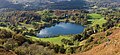
Loughrigg has two subsidiary ridges on its eastern flank. Lanty Scar provides the obvious line of ascent from Rydal, while the spur rising over Todd Crag leads up from Clappersgate. There are many areas of woodland on the lower slopes, giving way to a wide expanse of bracken-clad knolls and small tarns on the top. The summit is on the western side of the plateau and is identified by an Ordnance Survey column. Many lower tops also decorate the fell, sometimes to the confusion of visitors. Despite the girdle of lakes only Windermere is visible from the summit.(Elterwater,and grassmere are visible) The vista is open to the south over the green and blue country of Furness, with many fells in view on the other three sides.

The fell is easily accessible, being surrounded by roads on all sides. Ambleside and the smaller settlements of Skelwith Bridge, Elterwater, Grasmere and Rydal are all within reach, as is the popular double car park at White Moss Common. Many paths run over the fell including the well known Loughrigg Terrace, a level path with superb views of Grasmere, Helm Crag and the Fairfield group. Just beyond the eastern end of the Terrace are some quite remarkable caves, caused by quarrying. They penetrate about 150 feet (46 m) into the hillside and are often full of water; there are other small mines on the fell.

Geology

The geology is complex with the dacitic welded lapilli-tuff and volcaniclastic sandstone of the Lincomb Tarns Formation outcropping on the south-eastern slopes. Nearer the summit are intrusions rhyolite and sills of basaltic andesite. Drift deposits overlie the north-western flanks. [1]

Summit

The highest rocky knoll can be identified by an Ordnance Survey triangulation column beside a large cairn, both standing out from the turf. The view includes intimate views of the Langdale Pikes and the fells around Grasmere, together with the Fairfield horseshoe and the Coniston Fells. Elter Water, Grasmere and a large part of Windermere can also be seen. [2] [3]

Panorama of the summit of Loughrigg Fell Summit of Loughrigg Fell.jpg
Panorama of the summit of Loughrigg Fell

Ascents

An easy way up Loughrigg is from the White Moss car park, on the A591 between Grasmere and Rydal Water. This simple walk entails only around 700 ft (210 m) of ascent over 1.5 miles (2.4 km). From the car park a trail leads through woods onto Loughrigg Terrace. From the end of the terrace a path leads up left steeply over steps to the wide, undulating top area. Ascents are also possible from any of the surrounding settlements with manifold variations.

Loughrigg Fell is on the route of the Windermere Way, a long distance footpath that circumambulates Windermere.

The summit is the middle one of three visible knolls. [2] [3]

Related Research Articles

<span class="mw-page-title-main">Fairfield (Lake District)</span> Fell in the English Lake District

Fairfield is a fell in the English Lake District. It is the highest of a group of hills in the Eastern Fells, standing to the south of the Helvellyn range.

<span class="mw-page-title-main">High Raise (Langdale)</span> Mountain in the English Lake District, Cumbria, England

High Raise is a fell in the Central Fells of the English Lake District, not to be confused with another High Raise situated in the Far Eastern Fells. High Raise is one of the most spectacular mountains in the district; with a height of 762 metres (2,500 ft) it is the highest point in the central fells of Lakeland.

<span class="mw-page-title-main">River Rothay</span> River in Cumbria, England

The Rothay is a spate river of the Lake District in north-west England. Its name comes from Old Norse and translates literally as the red one. This has come to mean trout river. It rises close to Rough Crag above Dunmail Raise at a point about 1542 feet above sea level. Its catchment area covers Grasmere Common including Easedale Tarn, the southern flanks of Fairfield, and several of the fells to the east of Dunmail Raise, including Great Rigg, Rydal Fell, Scandale Fell and Heron Pike.

<span class="mw-page-title-main">Dollywaggon Pike</span> Mountain in the English Lake District, Cumbria, England

Dollywaggon Pike is a fell in the English Lake District. It stands on the main spine of the Helvellyn range in the Eastern Fells, between Thirlmere and the Ullswater catchment.

<span class="mw-page-title-main">Yoke (Lake District)</span> Fell in the Lake District, Cumbria, England

Yoke is a fell in the Lake District in Cumbria, England. It has a height of 706 metres (2,316 ft) and is situated in the far eastern sector of the national park, 6+12 kilometres ENE of the town of Ambleside. Yoke is the southern extremity of the long ridge that runs southwards from the fell of High Street. Yoke’s name is believed to be derived from the Old English language word geoc which is similar to the German word joch meaning mountain ridge.

<span class="mw-page-title-main">Dove Crag</span> Fell in the English Lake District

Dove Crag is a fell in the English Lake District. Situated in the Eastern Fells of the national park, seven kilometres south-south-west of Glenridding, it reaches a height of 792 metres. The fell is often climbed as part of the Fairfield horseshoe walk but a direct ascent from Patterdale is required to show the fell's full potential, displaying the impressive crags just to the north east of the summit. The highest point was originally unnamed on maps, being just a minor top, but over the years the summit has adopted the name of Dove Crag by mutual accord..

<span class="mw-page-title-main">Tarn Crag (Easedale)</span> Fell in the Lake District, Cumbria, England

Tarn Crag is a fell in the Central Fells of the English Lake District. Strictly the name refers only to the rock face looking down upon Easedale Tarn, but Alfred Wainwright applied it to the entire ridge lying between the Easedale and Far Easedale valleys in his Pictorial Guide to the Lakeland Fells

<span class="mw-page-title-main">Low Pike</span>

Low Pike is a small fell in the English Lake District. It has a modest height of 508 m (1,667 ft) and is situated three kilometres north of Ambleside. Low Pike is well seen from the streets of the town as the first prominent fell on the ridge which continues northwards for a further four kilometres to Fairfield. This ridge is part of the Fairfield horseshoe walk and Low Pike is most commonly ascended as part of this.

<span class="mw-page-title-main">Heron Pike</span>

Heron Pike is a fell in the English Lake District, two kilometres east of Grasmere. It is part of the Fairfield group in the Eastern Fells. It should not be confused with the Heron Pike that forms part of Sheffield Pike, although it appears that, by coincidence, both Heron Pikes are exactly the same height.

Blea Rigg is a fell in the English Lake District, lying between the valleys of Easedale and Great Langdale. One of the Central Fells, it is a broad plateau with a succession of rocky tops. Many routes of ascent are possible, beginning either from Grasmere or Great Langdale, though the paths are often poorly marked and hard to follow.

<span class="mw-page-title-main">Silver How</span> Fell in the Lake District, Cumbria, England

Silver How is a fell in the English Lake District, standing over the village of Grasmere. How, derived from the Old Norse word haugr, is a common local term for a hill or mound.

<span class="mw-page-title-main">Great Rigg</span>

Great Rigg is a fell in the English Lake District, 7 kilometres north-west of Ambleside and reaching a height of 766 metres. It is most often climbed as part of the Fairfield horseshoe, a 16-km circular walk which starts and finishes in Ambleside. The fell's name originates from the Old English "Rigg", meaning a bumpy or knobbly ridge.

<span class="mw-page-title-main">Lingmoor Fell</span> Fell in the Lake District, Cumbria, England

Lingmoor Fell is a fell in the English Lake District, situated eight kilometres west of Ambleside. The fell reaches a height of 469 m (1,540 ft) and divides the valleys of Great Langdale and Little Langdale. The fell's name originates from the Old Norse word lyng meaning “heather covered”. The actual summit of the fell is named as Brown How on Ordnance Survey maps.

<span class="mw-page-title-main">Nab Scar</span> Mountain in the English Lake District, Cumbria, England

Nab Scar is a fell in the English Lake District, an outlier of the Fairfield group in the Eastern Fells. It stands above Rydal Water.

<span class="mw-page-title-main">Black Fell (Lake District)</span> Fell in the Lake District, United Kingdom

Black Fell is a fell in the English Lake District. It rises to the north of Tarn Hows, between Coniston and Hawkshead.

<span class="mw-page-title-main">Rydal, Cumbria</span> Village in England

Rydal is a village in Cumbria, England. It is a small cluster of houses, a hotel, and St Mary's Church, on the A591 road midway between Ambleside and Grasmere.

The Central Fells are a part of the Cumbrian Mountains in the Lake District of England. Reaching their highest point at High Raise, they occupy a broad area to the east of Borrowdale. The Central Fells are generally lower than the surrounding hills, the Lake District's dome-like structure having a slight dip in the middle. The range extends from the boggy ridge between Derwentwater and Thirlmere in the north, to the rock peaks of the Langdale Pikes in the south.

<span class="mw-page-title-main">Windermere Way</span>

The Windermere Way is a 45-mile circuit of Windermere, a lake in the English Lake District. The route is wholly within the Lake District National Park and takes in the summits of Wansfell, Loughrigg Fell and Gummer's How as well as passing through the towns of Ambleside and Windermere.

Todd Crag is a hill and a satellite peak of Loughrigg Fell at 224 m (735 ft) it is not classed as a fell but is a vantage point near Ambleside

References

  1. British Geological Survey: 1:50,000 series, sheet 38: BGS (1998)
  2. 1 2 Wainwright, A (1958). A Pictorial Guide to the Lakeland Fells, Book 3 The Central Fells. Westmorland Gazette.
  3. 1 2 Mark Richards: The Central Fells: Collins (2003): ISBN   0-00-711365-X