
Bowfell is a pyramid-shaped mountain lying at the heart of the English Lake District, in the Southern Fells area. It is the sixth-highest mountain in the Lake District and one of the most popular of the Lake District fells for walkers. It is listed in Alfred Wainwright's 'best half dozen' Lake District fells.

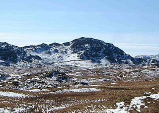
High Raise is a fell in the Central Fells of the English Lake District, not to be confused with another High Raise situated in the Far Eastern Fells. High Raise is one of the most spectacular mountains in the district; with a height of 762 metres (2,500 ft) it is the highest point in the central fells of Lakeland.

Raise is a fell in the English Lake District. It stands on the main spine of the Helvellyn range in the Eastern Fells, between Thirlmere and Ullswater.

High Seat is a fell in the centre of the English Lake District. Despite being below 2,000 ft it is the highest point for about 5 miles in any direction; a consequence of the curious fact that the centre of the district is lower than the surrounding parts.

White Side is a fell in the English Lake District. It is situated to the east of Thirlmere and to the west of Glenridding valley. This places White Side in the Helvellyn range of the Eastern Fells, with Raise to the north and Helvellyn Lower Man to the south, both of which are of greater height.

Dollywaggon Pike is a fell in the English Lake District. It stands on the main spine of the Helvellyn range in the Eastern Fells, between Thirlmere and the Ullswater catchment.

Kirk Fell is a fell in the Western part of the English Lake District. It is situated between Great Gable and Pillar on the long ring of fells surrounding the valley of Ennerdale, and also stands over Wasdale to the south. However, it is separated from its two higher neighbours by the low passes of Black Sail and Beck Head, giving it a high relative height and making it a Marilyn, the thirteenth highest in the Lake District.

Seatallan is a mountain in the western part of the English Lake District. It is rounded, grassy and fairly unassuming, occupying a large amount of land. However, it is classed as a Marilyn because of the low elevation of the col connecting it to Haycock, its nearest higher neighbour to the north. The name Seatallan is believed to have a Cumbric origin, meaning "Aleyn's high pasture".
High Rigg is a small fell located in the English Lake District, approximately three miles southeast of the town of Keswick. It occupies an unusual position, surrounded on all sides by higher fells but not connected by any obvious ridge. This separation from its fellows ensures that it is a Marilyn.
Great Crag is a fell in the English Lake District, located near the hamlets of Rosthwaite and Stonethwaite in Borrowdale.
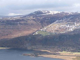
Bleaberry Fell is a fell in the Lake District in Cumbria, England, with a height of 590 metres (1,936 feet). It stands on the main watershed between Borrowdale and Thirlmere and can be climbed from either flank. Walla Crag is a subsidiary top of Bleaberry Fell.

Red Pike is a fell in the English Lake District. It is 826 m or 2,709 ft (826 m) high and lies due north of Wast Water. It is often climbed as part of the Mosedale Horseshoe, a walk which also includes Pillar.

Ullscarf is a fell in the English Lake District close to the geographical centre of the Cumbrian hills. It forms part of the watershed between the Derwentwater and Thirlmere catchments, a ridge running broadly north-south.
Armboth Fell is a fell in the English Lake District, regarded by Alfred Wainwright as the centre of Lakeland. It is named for the former settlement of Armboth. The fell is a domed plateau, three-quarters of a mile across, jutting out to the east of the Derwentwater-Thirlmere watershed, in the Borough of Allerdale. The fell is wet underfoot, with large areas clad in heather. The eastern slopes above Thirlmere have been planted with conifers.

Raven Crag is a fell in the English Lake District that overlooks Thirlmere reservoir. It has subsidiary summits The Benn and Castle Crag.

Steel Fell is a fell in the English Lake District, lying between Thirlmere and Grasmere. It is triangular in plan, the ridges running north, west and south east. Steel Fell rises to the west of the Dunmail Pass road and can be climbed from the summit, or from Grasmere and Wythburn.

Tarn Crag is a fell in the Central Fells of the English Lake District. Strictly the name refers only to the rock face looking down upon Easedale Tarn, but Alfred Wainwright applied it to the entire ridge lying between the Easedale and Far Easedale valleys in his Pictorial Guide to the Lakeland Fells
Blea Rigg is a fell in the English Lake District, lying between the valleys of Easedale and Great Langdale. One of the Central Fells, it is a broad plateau with a succession of rocky tops. Many routes of ascent are possible, beginning either from Grasmere or Great Langdale, though the paths are often poorly marked and hard to follow.

Calf Crag is a fell in the English Lake District, on the eastern side of the High Raise massif.
The Central Fells are a group of hills in the English Lake District. Reaching their highest point at High Raise, they occupy a broad area to the east of Borrowdale. The Central Fells are generally lower than the surrounding hills, the Lake District's dome-like structure having a slight dip in the middle. The range extends from the boggy ridge between Derwentwater and Thirlmere in the north, to the rock peaks of the Langdale Pikes in the south.

