
Great Dodd is a mountain or fell in the English Lake District. It stands on the main ridge of the Helvellyn range, a line of mountains which runs in a north–south direction between the lakes of Thirlmere and Ullswater in the east of the Lake District. Great Dodd, with a height of 857 metres (2,812 ft) is the highest of the fells in this range to the north of Sticks Pass.

Dale Head is a fell in the north-western sector of the Lake District, in northern England. It is 753 metres above sea level and stands immediately north of Honister Pass, the road between Borrowdale and Buttermere.

Robinson is a fell in the English Lake District, its southern slopes descending to Buttermere, while its northern side is set in the Newlands Valley. Paths lead to the summit from the village of Buttermere, from the nearby summit Dale Head and from various locations in the valleys to the north.

Place Fell is a mountain in the English Lake District. It stands at the corner of the upper and middle reaches of Ullswater, with steep western flanks overlooking the villages of Glenridding and Patterdale.

Grasmoor is a mountain in the north-western part of the Lake District, northern England. It is the highest peak in a group of hills between the villages of Lorton, Braithwaite and Buttermere, and overlooks Crummock Water.

High Seat is a fell in the centre of the English Lake District. Despite being below 2,000 feet in elevation, it is the highest point for about five miles in any direction; a consequence of the curious fact that the centre of the district is lower than the surrounding parts.
Crag Hill is a mountain in the North Western part of the English Lake District. It was formerly known as Eel Crag; however, the Ordnance Survey now marks Eel Crag as referring to the northern crags of the fell. It is not to be confused with another Crag Hill lying on the border of North Yorkshire.
High Stile is a mountain in the western part of the Lake District in North West England. It is the eleventh-highest English Marilyn, standing 807 metres (2,648 ft) high, and has a relative height of 362 metres (1,188 ft).

Causey Pike is a fell in the English Lake District. It is situated in the Newlands Valley, 5 kilometres south-west of the town of Keswick. Even though it has a modest height of 637 metres (2,090 ft) it is one of the most distinctive fells when viewed from the Derwent Water and Keswick area due to its distinguishing summit "knobble" which catches the eye. The fell is one of 214 fells described by Alfred Wainwright in his series of Pictorial Guides to the Lakeland Fells: Causey Pike features in Book Six, The North Western Fells.
High Rigg is a small fell located in the English Lake District, approximately three miles southeast of the town of Keswick. It occupies an unusual position, surrounded on all sides by higher fells but not connected by any obvious ridge. This separation from its fellows ensures that it is a Marilyn.

Castle Crag is a hill in the North Western Fells of the English Lake District. It is the smallest hill included in Alfred Wainwright's influential Pictorial Guide to the Lakeland Fells, the only Wainwright below 1,000 feet (300 m).

Latrigg is one of the lowest fells in the Lake District in North West England, but is a popular climb due to its convenient location overlooking the town of Keswick and the beautiful views down the valley of Borrowdale from the summit. It is the least mountainous of the Skiddaw fells, the summit being almost entirely devoid of rock. The slopes of Latrigg are partially wooded, and logging work is currently being undertaken. One lone tree just south of the summit is prominently viewed in silhouette when approaching Keswick from the west along the A66. It also has petrified trees on top.
Outerside is a fell in the Lake District in Cumbria, England. It is located 6 kilometres west of Keswick in the north western part of the national park and is a smaller member of the Coledale group of fells with a height of 568 metres. The fell is part of a ridge on the southern side of Coledale which descends from the higher fell of Scar Crags and continues over the neighbouring smaller fell of Barrow before reaching the valley at the village of Braithwaite.
Bleaberry Fell is a fell in the Lake District in Cumbria, England, with a height of 590 metres (1,936 ft). It stands on the main watershed between Borrowdale and Thirlmere and can be climbed from either flank. Walla Crag is a subsidiary top of Bleaberry Fell.

Scar Crags is a fell in the north western part of the English Lake District in the county of Cumbria. It is one of the Coledale group of fells situated seven kilometres south west of Keswick and reaches a height of 672 metres (2,205 ft).

Red Pike is a fell in the High Stile range in the western English Lake District, which separates Ennerdale from the valley of Buttermere and Crummock Water. It is 2,476 ft (755 m) high. The direct ascent of Red Pike from Buttermere is very popular and the ridge walk from Red Pike to Haystacks is regarded as one of the finest in the area, with excellent views of the Scafells, Great Gable and Pillar.

Ullscarf is a fell in the English Lake District close to the geographical centre of the Cumbrian hills. It forms part of the watershed between the Derwentwater and Thirlmere catchments, a ridge running broadly north-south.
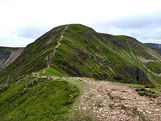
Brock Crags is a fell in the English Lake District, standing above Hartsop in the Far Eastern Fells. It forms part of the perimeter of Martindale, lying on the long ridge from Rampsgill Head to Place Fell.
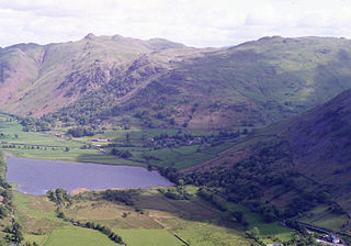
Hartsop above How is a fell in the English Lake District, an outlier of the Helvellyn range in the Eastern Fells. It stands above Brothers Water and the Ullswater–Ambleside road.
The Central Fells are a part of the Cumbrian Mountains in the Lake District of England. Reaching their highest point at High Raise, they occupy a broad area to the east of Borrowdale. The Central Fells are generally lower than the surrounding hills, the Lake District's dome-like structure having a slight dip in the middle. The range extends from the boggy ridge between Derwentwater and Thirlmere in the north, to the rock peaks of the Langdale Pikes in the south.


