
Fairfield is a fell in the English Lake District. It is the highest of a group of hills in the Eastern Fells, standing to the south of the Helvellyn range.

Robinson is a fell in the English Lake District, its southern slopes descending to Buttermere, while its northern side is set in the Newlands Valley. Paths lead to the summit from the village of Buttermere, from the nearby summit Dale Head and from various locations in the valleys to the north.

Place Fell is a mountain in the English Lake District. It stands at the corner of the upper and middle reaches of Ullswater, with steep western flanks overlooking the villages of Glenridding and Patterdale.

High Raise is a fell in the Central Fells of the English Lake District, not to be confused with another High Raise situated in the Far Eastern Fells. High Raise is one of the most spectacular mountains in the district; with a height of 762 metres (2,500 ft) it is the highest point in the central fells of Lakeland.

Esk Pike is a fell in the English Lake District, one of the cirque of hills forming the head of Eskdale.
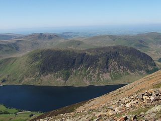
Mellbreak is a hill in the Western part of the English Lake District. Despite being surrounded on all sides by higher fells, it stands in isolation. It is surrounded on three sides by a "moat" of deep marshy land, and on the east side by the lake of Crummock Water. The fell forms a partnership with the lake, running parallel to it, falling sheer into it, and regularly providing the backdrop for pictures of it.

Rest Dodd is a fell in the English Lake District. It is situated in the quieter far eastern region of the national park and reaches a height of 696 metres (2,283 ft). Rest Dodd is a fell that is often by-passed by walkers as they travel the busy footpath between Ullswater and Haweswater either to climb the more significant fell of High Street or strive to complete Alfred Wainwright’s Coast to Coast Walk. Indeed Wainwright describes Rest Dodd as “A fell of little interest although the east flank falls spectacularly in fans of colourful scree”. The fell is usually climbed in conjunction with other nearby "Wainwright" fells such as The Nab, Brock Crags and Angletarn Pikes.

Rannerdale Knotts is a fell in the Lake District of Cumbria, England. Rising from the Buttermere valley, it is one of the smaller Cumbrian hills and is overlooked by a number of surrounding fells, such as Grasmoor, Whiteless Pike and, across Crummock Water, Mellbreak and the High Stile ridge. Rannerdale Knotts is said to be the site of a battle between the native Cumbrians and Norsemen and the invading Normans in the late 11th or early 12th century.

Angletarn Pikes is a fell in the English Lake District near the village of Patterdale. Its most notable feature is Angle Tarn from which it derives its name.

Sergeant Man is a fell in the English Lake District. It is properly a secondary summit of High Raise, but is given a separate chapter by Alfred Wainwright in his third Pictorial Guide nonetheless, as it "is so prominent an object and offers so compelling a challenge". Its rocky cone is indeed in great contrast to the grassy dome of High Raise.

Helm Crag is a fell in the English Lake District situated in the Central Fells to the north of Grasmere. Despite its low height it sits prominently at the end of a ridge, easily seen from the village. This, combined with the distinctive summit rocks which provide the alternative name 'The Lion and the Lamb', makes it one of the most recognised hills in the District.

Steel Fell is a fell in the English Lake District, lying between Thirlmere and Grasmere. It is triangular in plan, the ridges running north, west and south east. Steel Fell rises to the west of the Dunmail Raise road and can be climbed from the summit, or from Grasmere and Wythburn.

Tarn Crag is a fell in the Central Fells of the English Lake District. Strictly the name refers only to the rock face looking down upon Easedale Tarn, but Alfred Wainwright applied it to the entire ridge lying between the Easedale and Far Easedale valleys in his Pictorial Guide to the Lakeland Fells
Blea Rigg is a fell in the English Lake District, lying between the valleys of Easedale and Great Langdale. One of the Central Fells, it is a broad plateau with a succession of rocky tops. Many routes of ascent are possible, beginning either from Grasmere or Great Langdale, though the paths are often poorly marked and hard to follow.

Calf Crag is a fell in the English Lake District, on the eastern side of the High Raise massif.

Wether Hill is a fell in the English Lake District, between Martindale and Haweswater. It lies on the main north-south ridge of the Far Eastern Fells between Loadpot Hill and High Raise. Lesser ridges also radiate out to the east and north-west. It should not be confused with Wether Hill in north Northumberland.

Beda Fell is a fell in the English Lake District, situated to the south of Ullswater. It divides the valleys of Boredale and Bannerdale within the Martindale system.

Wetherlam is a mountain in the English Lake District. It is the most northerly of the Coniston Fells, the range of fells to the north-west of Coniston village; its north-east slopes descend to Little Langdale.
Hartsop above How is a fell in the English Lake District, an outlier of the Helvellyn range in the Eastern Fells. It stands above Brothers Water and the Ullswater–Ambleside road.
The Central Fells are a part of the Cumbrian Mountains in the Lake District of England. Reaching their highest point at High Raise, they occupy a broad area to the east of Borrowdale. The Central Fells are generally lower than the surrounding hills, the Lake District's dome-like structure having a slight dip in the middle. The range extends from the boggy ridge between Derwentwater and Thirlmere in the north, to the rock peaks of the Langdale Pikes in the south.
