Pavey Ark

Last updated

Pavey Ark
Lake District National Park UK relief location map.png
Red triangle with thick white border.svg
Pavey Ark
Location in Lake District, UK
Highest point
Elevation 700 m (2,300 ft)
Prominence c.15 m
Parent peak Thunacar Knott
Listing Wainwright, Nuttall
Coordinates 54°27′41″N3°06′16″W / 54.46142°N 3.10451°W / 54.46142; -3.10451
Geography
Location Cumbria, England
Parent range Lake District, Central Fells
OS grid NY285079
Topo map OS Explorer OL6

Pavey Ark is a fell in the English county of Cumbria. It is one of the Langdale Pikes, lying to the north of Great Langdale, in the heart of the Lake District, immediately to the north-east of Harrison Stickle.

Contents

Topography

From the shores of Stickle Tarn, Pavey Ark gives the impression of being a rocky ridge. In fact this is misleading, and the north-western side is simply an undulating area of moorland, rising towards Thunacar Knott. The summit plateau is characterised by tarns, rocky outcrops and bilberry terraces.

Pavey Ark is the largest cliff in the Langdales, but faces east over Stickle Tarn and is less prominent from the floor of Great Langdale away to the south. The main face is a little over 14 mile (400 metres) across and drops about 400 feet (120 metres). To the southwest it merges into the crags of Harrison Stickle, while the northern end peters out into the valley of Bright Beck. Stickle Tarn is wholly within the territory of the Ark, a corrie tarn which has been dammed to create additional capacity. The stone-faced barrage is low enough not to spoil the character of the pool, and the water is used for public consumption in the hotels and homes below. The tarn has a depth of around 50 feet (15 metres). [1]

Geology

The face is an outcrop of the formation named for the fell, the Pavey Ark Member. This consists of pebbly sandstone and breccia and is set within the Seathwaite Fell Formation of volcaniclastic sandstone with interbeds of tuff, lapilli-tuff, breccia and conglomerate. [2]

Ascents

Looking at Jack's Rake from Stickle Tarn. Walkers can be seen ascending the rake. Jack's Rake.jpg
Looking at Jack's Rake from Stickle Tarn. Walkers can be seen ascending the rake.

Pavey Ark is most often climbed from the New Dungeon Ghyll Hotel, located some 1+14 miles (2 kilometres) south. The route follows Mill Gill up to Stickle Tarn, which can also be reached via a much less popular and more strenuous path following the Dungeon Ghyll ravines. From Stickle Tarn there is a choice of routes; one of the most popular is to follow a diagonal slit on Pavey Ark's craggy south-eastern face. This route is known as Jack's Rake, and requires scrambling. Alternative, easier, ascents are available on either side of the main crag.

Jack's Rake is the most famous ascent of the Pavey Ark precipice. It is classified as a Grade 1 scramble, but it is within the capability of many walkers, though it does require a head for heights and is considerably harder in bad weather. The rake starts beneath the East Buttress at the precipice's eastern end, near a large cairn (with a tablet marked 'JWS 1900') immediately north of Stickle Tarn, and then climbs west across the face of the crag. The rake follows a natural groove in the precipice face and is clearly indicated by several Ash trees. Wainwright wrote that for fellwalkers Jack's Rake is "difficult and awkward", although there is "curiously little sense of exposure, for a comforting parapet of rock accompanies all the steeper parts of the ascent". [3] The summit is a short walk from the top exit of the rake, which is also used as a descent route by rock climbers accessing the climbs on the cliff face.

In two separate incidents, two walkers fell to their deaths from Jack's Rake in June 2012. [4]

As with Lord's Rake on Scafell Crag, the word 'rake' refers to a path across major precipices, originally used by climbers for access to rock climbs, but which can also be used by walkers.

Pavey Ark can also be ascended from Stickle Tarn via Easy Gully, North Rake or by the path to Harrison Stickle. Easy Gully is a steep walk on scree between the crags at the eastern end of the precipice, starting from the same place as Jack's Rake, and is blocked by large boulders near the top, where tough scrambling is required. North Rake (so named by Wainwright) starts from the path to High Raise at the very eastern end of the cliff and rises west over the top of the East Buttress. This is a much less exposed and strenuous walking route to the summit. [3]

Summit

There is no cairn on the bare rock of the summit, set back a few yards from the edge and a little to the north of the exit from Jack's Rake. The view north-west is perhaps spoilt by the long slopes of High Raise, but the Eastern and Southern Fells are well seen [5]

Rock climbing

The Pavey Ark crag is split by several large gullies and chimneys: Little Gully, Great Gully, Crescent Gully, Gwynne's Chimney, and Rake End Chimney. Other rock climbs include Crescent Slabs, Arcturus, Cruel Sister, Mother Courage, Sixpence, and Impact Day (E8 6c), and Lexicon (E11 7a).

Pavey Ark by nagualdesign.jpg
A panoramic image of Pavey Ark. Jack's Rake can be traced from the lower right to the upper left. Two pairs of rock climbers can be seen ascending a more challenging route, and a pair of walkers stand at the summit. To the left is Harrison Stickle, and the winding path back down to the tarn.

Related Research Articles

<span class="mw-page-title-main">Scafell</span> Mountain in the English Lake District, Cumbria, England

Scafell is a mountain in the Lake District region of Cumbria, England. It has a height of 964 metres, making it the second-highest mountain in England after its neighbour, Scafell Pike, from which it is separated by Mickledore col.

<span class="mw-page-title-main">Great Gable</span> Mountain in the United Kingdom

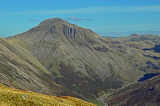
Great Gable is a mountain in the Lake District, United Kingdom. It is named after its appearance as a pyramid from Wasdale, though it is dome-shaped from most other directions. It is one of the most popular of the Lakeland fells, and there are many different routes to the summit. Great Gable is linked by the high pass of Windy Gap to its smaller sister hill, Green Gable, and by the lower pass of Beck Head to its western neighbour, Kirk Fell.

<span class="mw-page-title-main">Bowfell</span> Mountain in the English Lake District, Cumbria, England

Bowfell is a pyramid-shaped mountain lying at the heart of the English Lake District, in the Southern Fells area. It is the sixth-highest mountain in the Lake District and one of the most popular of the Lake District fells for walkers. It is listed in Alfred Wainwright's 'best half dozen' Lake District fells.

<span class="mw-page-title-main">Fairfield (Lake District)</span> Fell in the English Lake District

Fairfield is a fell in the English Lake District. It is the highest of a group of hills in the Eastern Fells, standing to the south of the Helvellyn range.

<span class="mw-page-title-main">Great End</span> Mountain in the Lake District, England

Great End is the most northerly mountain in the Scafell chain, in the English Lake District. From the south it is simply a lump continuing this chain. From the north, however, it appears as an immense mountain, with an imposing north face rising above Sprinkling Tarn (lake). This is a popular location for wild camping, and the north face attracts many climbers.

<span class="mw-page-title-main">High Raise (Langdale)</span> Mountain in the English Lake District, Cumbria, England

High Raise is a fell in the Central Fells of the English Lake District, not to be confused with another High Raise situated in the Far Eastern Fells. High Raise is one of the most spectacular mountains in the district; with a height of 762 metres (2,500 ft) it is the highest point in the central fells of Lakeland.

<span class="mw-page-title-main">Great Langdale</span> Valley in Cumbria, England

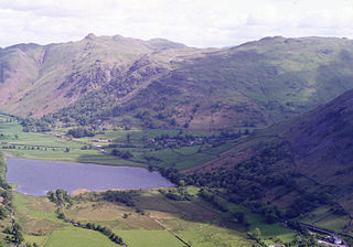
Great Langdale is a valley in the Lake District National Park in North West England, the epithet "Great" distinguishing it from the neighbouring valley of Little Langdale. Langdale is also the name of a valley in the Howgill Fells, elsewhere in Cumbria.

<span class="mw-page-title-main">Loft Crag</span> Mountain in the English Lake District, Cumbria, England

Loft Crag is a fell in the English Lake District, situated nine kilometres west of Ambleside in the valley of Great Langdale. Along with the neighbouring fells of Harrison Stickle and Pike of Stickle it forms the picturesque Langdale Pikes, which when viewed from the area around Elterwater village gives one of the best-known views in the National Park.

<span class="mw-page-title-main">Pike of Stickle</span> Mountain in the English Lake District, Cumbria, England

Pike of Stickle, also known as Pike o’ Stickle, is a fell in the English Lake District. It reaches a height of 709 metres (2,326 ft) and is situated in the central part of the national park in the valley of Great Langdale. The fell is one of three fells which make up the picturesque Langdale Pikes, one of the best-known areas in Lakeland. A "stickle" is a hill with a steep prominent rocky top, while a "pike" is a hill with a peaked summit, the name being therefore partly tautological.

<span class="mw-page-title-main">Pike of Blisco</span> Mountain in the English Lake District, Cumbria, England

Pike of Blisco, or Pike o' Blisco, is a mountain in the Lake District in Cumbria, England. Located between the valleys of Great Langdale and Little Langdale, its relative isolation from neighbouring fells together with slopes falling away immediately from the summit in all directions mean it has excellent views: the view of the Langdale Pikes across Great Langdale is particularly arresting.

<span class="mw-page-title-main">Harrison Stickle</span> Mountain in the English Lake District, Cumbria, England

Harrison Stickle is a fell in the central part of the English Lake District, situated above Great Langdale. The fell is one of the three fells which make up the picturesque Langdale Pikes, the others being Pike of Stickle and Loft Crag. Together they make up one of the most picturesque, and probably the best-known, mountain groups in the District. A "stickle" is a hill with a prominent rocky top.

<span class="mw-page-title-main">Thunacar Knott</span> Fell in the Lake District, Cumbria, England

Thunacar Knott is a fell in the central part of the English Lake District in the county of Cumbria.

<span class="mw-page-title-main">Sergeant Man</span>

Sergeant Man is a fell in the English Lake District. It is properly a secondary summit of High Raise, but is given a separate chapter by Alfred Wainwright in his third Pictorial Guide nonetheless, as it "is so prominent an object and offers so compelling a challenge". Its rocky cone is indeed in great contrast to the grassy dome of High Raise.

<span class="mw-page-title-main">Dow Crag</span> Fell in the Lake District, Cumbria, England

Dow Crag is a fell in the English Lake District near Coniston, Cumbria. The eastern face is one of the many rock faces in the Lake District used for rock climbing.

<span class="mw-page-title-main">Sergeant's Crag</span>

Sergeant's Crag is a fell in the English Lake District. It is an intermediate height on the ridge between the Langstrath and Greenup valleys in the Central Fells.

<span class="mw-page-title-main">Tarn Crag (Easedale)</span> Fell in the Lake District, Cumbria, England

Tarn Crag is a fell in the Central Fells of the English Lake District. Strictly the name refers only to the rock face looking down upon Easedale Tarn, but Alfred Wainwright applied it to the entire ridge lying between the Easedale and Far Easedale valleys in his Pictorial Guide to the Lakeland Fells

Blea Rigg is a fell in the English Lake District, lying between the valleys of Easedale and Great Langdale. One of the Central Fells, it is a broad plateau with a succession of rocky tops. Many routes of ascent are possible, beginning either from Grasmere or Great Langdale, though the paths are often poorly marked and hard to follow.

<span class="mw-page-title-main">Brock Crags</span> Fell in the Lake District, Cumbria, England

Brock Crags is a fell in the English Lake District, standing above Hartsop in the Far Eastern Fells. It forms part of the perimeter of Martindale, lying on the long ridge from Rampsgill Head to Place Fell.

<span class="mw-page-title-main">Rossett Pike</span>

Rossett Pike is a fell in the English Lake District. It is located at the head of Mickleden, one of two tributary valleys of Great Langdale.

The Central Fells are a part of the Cumbrian Mountains in the Lake District of England. Reaching their highest point at High Raise, they occupy a broad area to the east of Borrowdale. The Central Fells are generally lower than the surrounding hills, the Lake District's dome-like structure having a slight dip in the middle. The range extends from the boggy ridge between Derwentwater and Thirlmere in the north, to the rock peaks of the Langdale Pikes in the south.

References

  1. Blair, Don: Exploring Lakeland Tarns: Lakeland Manor Press (2003): ISBN   0-9543904-1-5
  2. British Geological Survey 1:50,000 series maps: Sheet 38: BGS (1998)
  3. 1 2 Wainwright, A (1958). A Pictorial Guide to the Lakeland Fells, Book 3 The Central Fells. Westmorland Gazette.
  4. "Second walker dies falling on Pavey Ark in Lake District". BBC News. 21 June 2012.
  5. Mark Richards: The Central Fells: Collins (2003): ISBN   0-00-711365-X