Great Crag | |
---|---|
Highest point | |
Elevation | 440 m (1,440 ft) |
Prominence | 27 m (89 ft) |
Parent peak | Ullscarf |
Listing | Wainwright |
Coordinates | 54°31′20″N3°07′51″W / 54.52229°N 3.13087°W |
Geography | |
Location in the Lake District National Park | |
Location | Cumbria, England |
Parent range | Lake District, Central Fells |
OS grid | NY269147 |
Topo map | OS Explorer OL4 |
Great Crag is a fell in the English Lake District, located near the hamlets of Rosthwaite and Stonethwaite in Borrowdale.
The higher slopes are heather-covered and quite rocky, while the lower steep slopes on the Borrowdale side are covered by a mature oak wood. Half a kilometre south-east of the summit lies the attractive Dock Tarn which is often visited by walkers on their way to or from Great Crag. [1]
At 440 metres (1,444 ft), Great Crag is not high by Lake District standards, and its small topographic prominence means that it is essentially a minor summit on the broad north-western slopes of Ullscarf. However, its rocky summit stands out amid the relatively featureless moorland and is the culmination of a steep slope rising out of Borrowdale; this ensures that it is considered a fell in its own right, and it is given this status in Alfred Wainwright's Pictorial Guide to the Lakeland Fells.
The summit area is composed of the plagioclase-phyric andesite lavas of the Birker Fell Formation with the andesitic lapilli tuff of the Wet Side Edge Member outcropping to the south. Small intrusions of dolerite are also present. [2]
Ascents of Great Crag can be started from the hamlets of Rosthwaite, Stonethwaite or Watendlath. The Rosthwaite route uses the bridleway to Watendlath until the highest point is reached then goes southerly over boggy moorland and then more firmer rocky ground to reach the summit. The Stonethwaite path climbs steeply through woodland before reaching Dock Tarn; it is then a short ascent from the tarn north-westwards to the summit. These two routes can be combined to make a circular walk starting and finishing in Rosthwaite. The ascent from Watendlath utilises the popular path to Dock Tarn which has been diverted by signposts to avoid the worst of the boggy ground to the north of the fell; this path takes the walker very close to the summit and it is a simple climb through heather to attain the highest point. [3] [4]
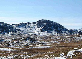
The highest point of the fell is difficult to ascertain as there are two tops of very similar height marked by cairns. The view from the top is not extensive but there is a good prospect of Borrowdale with the higher fells behind. [5]
Bowfell is a pyramid-shaped mountain lying at the heart of the English Lake District, in the Southern Fells area. It is the sixth-highest mountain in the Lake District and one of the most popular of the Lake District fells for walkers. It is listed in Alfred Wainwright's 'best half dozen' Lake District fells.
Pavey Ark is a fell in the English county of Cumbria. It is one of the Langdale Pikes, lying to the north of Great Langdale, in the heart of the Lake District, immediately to the north-east of Harrison Stickle.
High Raise is a fell in the Central Fells of the English Lake District, not to be confused with another High Raise situated in the Far Eastern Fells. High Raise is one of the most spectacular mountains in the district; with a height of 762 metres (2,500 ft) it is the highest point in the central fells of Lakeland.
Nethermost Pike is a fell in Cumbria, England, and a part of the Lake District. At 891 metres (2,923 ft) it is the second highest Wainwright in the Helvellyn range, the highest of which is Helvellyn itself. It is located close to the southern end of the ridge, with Helvellyn to the north, and High Crag and Dollywaggon Pike to the south. Nethermost Pike, along with many of the Eastern Fells, lies between Thirlmere in the west and the Ullswater catchment in the east. The closest villages are Glenridding and Patterdale on the shores of Ullswater, over 8 kilometres (5 mi) away.
Haystacks, or Hay Stacks, is a hill in England's Lake District, situated at the south-eastern end of the Buttermere Valley. Although not of any great elevation, Haystacks has become one of the most popular fells in the area. This fame is partly due to the writings of Alfred Wainwright, who espoused its attractions and chose it as the place where he wanted his ashes scattered. Its large, undulating summit contains many rock formations, tarns and hidden recesses.
Thunacar Knott is a fell in the central part of the English Lake District in the county of Cumbria.
Seathwaite Fell is an area of the Lake District in Cumbria, England. It stands above the hamlet of the same name at the head of Borrowdale.
Grange Fell is a small fell in the English Lake District in the county of Cumbria, situated in the Borrowdale valley overlooking the villages of Grange in Borrowdale and Rosthwaite.
Dock Tarn is a small tarn located within the Lake District National Park in Cumbria, England, at grid reference NY273143. It is situated on moorland at 400 metres above sea level near the summit of Great Crag, midway between Watendlath, the Stonethwaite valley and Borrowdale. It measures approximately 300 by 200 metres, and the shoreline is indented with rocky headlands and bays. There is a tiny island in the tarn with a few small Rowan trees growing on it. Many Lake District writers rate Dock Tarn and the walk to it very highly because of its quiet beauty.
Eagle Crag is a fell in the Lake District in Cumbria, England, it is situated near the village of Stonethwaite where the valleys of Langstrath and Greenup join. Impressive walls of crag look down upon Stonethwaite, making Eagle Crag the most arresting sight from that settlement. It can be climbed direct by the average walker, picking a route between the rock faces.
Glaramara is a fell in the English Lake District in Cumbria. It is a substantial fell that is part of a long ridge that stretches for over six kilometres from Stonethwaite in Borrowdale up to the important mountain pass of Esk Hause. The summit of Glaramara at 783 metres (2,569 ft) is the central point of this ridge, which separates the valleys of Langstrath and Grains Gill. However, the ridge has two additional fells, numerous subsidiary tops and several small tarns making its traverse an appealing and challenging walk.
High Spy is a fell in the English Lake District it is situated on the ridge that separates the Newlands Valley from Borrowdale, eight kilometres south of Keswick.
Ullscarf is a fell in the English Lake District close to the geographical centre of the Cumbrian hills. It forms part of the watershed between the Derwentwater and Thirlmere catchments, a ridge running broadly north-south.
Rosthwaite Fell is a fell in the English Lake District. It is situated some 12 kilometres due south of Keswick and 2 kilometres south of the village of Rosthwaite in Borrowdale.
Slight Side is a fell in the English Lake District it stands 25 kilometres east southeast of the town of Whitehaven and reaches a height of 762 metres (2,499 ft). Slight Side lies at the south western edge of the Scafell Massif, a four-kilometre-long crescent of high ground which includes the highest ground in England. The fells names derives from the Old Norse language and means "The mountain shieling with the level pastures", it is a combination of the Norse words "sletta" and "saetr". With a shieling meaning a shepherds hut or a mountain pasture used in the summer.
Rossett Pike is a fell in the English Lake District. It is located at the head of Mickleden, one of two tributary valleys of Great Langdale.
Green Crag is a fell in the English Lake District. It stands between Eskdale and the Duddon valley in the Southern Fells.
The Central Fells are a part of the Cumbrian Mountains in the Lake District of England. Reaching their highest point at High Raise, they occupy a broad area to the east of Borrowdale. The Central Fells are generally lower than the surrounding hills, the Lake District's dome-like structure having a slight dip in the middle. The range extends from the boggy ridge between Derwentwater and Thirlmere in the north, to the rock peaks of the Langdale Pikes in the south.
The Southern Fells are a part of the Cumbrian Mountains in the Lake District of England. Including Scafell Pike, the highest peak in England, they occupy a broad area to the south of Great Langdale, Borrowdale and Wasdale. High and rocky towards the centre of the Lake District, the Southern Fells progressively take on a moorland character toward the south-west. In the south-east are the well-known Furness Fells, their heavily quarried flanks rising above Coniston Water.
The Northern Fells are a part of the Cumbrian Mountains in the Lake District of England. Including Skiddaw, they occupy a wide area to the north of Keswick. Smooth, sweeping slopes predominate, with a minimum of tarns or crags. Blencathra in the south-east of the group is the principal exception to this trend.