The Lake District, also known as the Lakes or Lakeland, is a mountainous region and national park in North West England. It is primarily famous for its mountain, lake, and coastal scenery, and for its literary associations with William Wordsworth and other Lake Poets, Beatrix Potter, and John Ruskin.

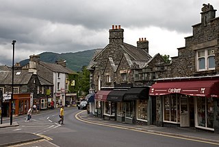
Ambleside is a town and former civil parish in the Westmorland and Furness district of Cumbria, England. Within the boundaries of the historic county of Westmorland and located in the Lake District National Park, the town sits at the head of Windermere, England's largest natural lake. In 2020 it had an estimated population of 2596.

Windermere is a ribbon lake in Cumbria, England, and part of the Lake District. It is the largest lake in England by length, area, and volume, but considerably smaller than the largest Scottish lochs and Northern Irish loughs.

Coniston Water is a lake in the Lake District in North West England. It is the third largest by volume, after Windermere and Ullswater, and the fifth-largest by area. The lake has a length of 8.7 kilometres, a maximum width of 730 metres (800 yd), and a maximum depth of 56.1 m. Its outflow is the River Crake, which drains into Morecambe Bay via the estuary of the River Leven. The lake is in the unitary authority of Westmorland and Furness, and the ceremonial county of Cumbria.

Grasmere is a village and former civil parish, now in the parish of Lakes, in the Westmorland and Furness district of Cumbria, England, and situated in the centre of the Lake District and named after its adjacent lake. Grasmere lies within the historic county of Westmorland. The Ambleside and Grasmere ward had an estimated population of 4,592 in 2019. William and Dorothy Wordsworth, the 'Lake Poets', lived in Grasmere for 14 years and called it "the loveliest spot that man hath ever found."

The Cumbria Way is a linear 112-kilometre (70-mile) long-distance footpath in Cumbria, England. The majority of the route is inside the boundaries of the Lake District National Park. Linking the two historic Cumbrian towns of Ulverston and Carlisle, it passes through the towns of Coniston and Keswick. The route cuts through Lakeland country via Coniston Water, Langdale, Borrowdale, Derwent Water, Skiddaw Forest and Caldbeck. It is a primarily low-level route with some high-level exposed sections.

Bassenthwaite Lake is a body of water in the Lake District in North West England, near the town of Keswick. It has an area of 5.3 km2 (2.0 sq mi), making the fourth largest of the lakes in the region. The lake has a length of approximately 4 miles (6.4 km) long and maximum width of 0.75 miles (1 km), a maximum depth of 19 m (62 ft), and a surface elevation of 68 m (223 ft) above sea level. Its primary inflow and outflow is the River Derwent, which drains into the Irish Sea at Workington. The lake is in the unitary authority of Cumberland, and the ceremonial county of Cumbria.

Ullswater is a glacial lake in Cumbria, England and part of the Lake District National Park. It is the second largest lake in the region by both area and volume, after Windermere. The lake is about 7 miles (11 km) long, 0.75 miles (1 km) wide, and has a maximum depth of 63 metres (207 ft). Its outflow is River Eamont, which meets the River Eden at Brougham Castle before flowing into the Solway Firth. The lake is in the administrative county of Westmorland and Furness and the ceremonial county of Cumbria.

Furness is a peninsula and region of Cumbria, England. Together with the Cartmel Peninsula it forms North Lonsdale, historically an exclave of Lancashire. On 1 April 2023 it became part of the new unitary authority of Westmorland and Furness.

Bowness-on-Windermere is a town and former civil parish, now in the parish of Windermere and Bowness, in the Westmorland and Furness district, in the ceremonial county of Cumbria, England. It lies next to Windermere lake and the town of Windermere to the north east and within the Lake District National Park. The town was historically part of the county of Westmorland and is also forms an urban area with Windermere. The town had a population of 3,814 in the 2011 Census.

The Brathay is a river of north-west England. Its name comes from Old Norse and means broad river. It rises at a point 1289 feet above sea level near the Three Shire Stone at the highest point of Wrynose Pass in the Lake District. Its catchment area includes the northern flanks of Wetherlam, Great Carrs and others of the Furness Fells, as well as a substantial area of the Langdale Fells.

The Rothay is a spate river of the Lake District in north-west England. Its name comes from Old Norse and translates literally as the red one. This has come to mean trout river. It rises close to Rough Crag above Dunmail Raise at a point about 1542 feet above sea level. Its catchment area covers Grasmere Common including Easedale Tarn, the southern flanks of Fairfield, and several of the fells to the east of Dunmail Raise, including Great Rigg, Rydal Fell, Scandale Fell and Heron Pike.

Great Langdale is a valley in the Lake District National Park in North West England, the epithet, "Great" distinguishing it from the neighbouring valley of Little Langdale. Langdale is also the name of a valley in the Howgill Fells, elsewhere in Cumbria.

Loughrigg Fell is a hill in the central part of the English Lake District. It stands on the end of the long ridge coming down from High Raise over Silver How towards Ambleside, and is separated from its neighbours by the depression of Red Bank.

Coniston is a village and civil parish in the Westmorland and Furness district of Cumbria, England. In the 2001 census the parish had a population of 1,058, decreasing at the 2011 census to 928. Within the boundaries of the historic county of Lancashire, it is in the southern part of the Lake District National Park, between Coniston Water, the third longest lake in the Lake District, and Coniston Old Man.

Rydal Water is a small body of water in the central part of the English Lake District, in the county of Cumbria. It is located near the hamlet of Rydal, between Grasmere and Ambleside in the Rothay Valley.

Cumbrian toponymy refers to the study of place names in Cumbria, a county in North West England, and as a result of the spread of the ancient Cumbric language, further parts of northern England and the Southern Uplands of Scotland.

Lingmoor Fell is a fell in the English Lake District, situated eight kilometres west of Ambleside. The fell reaches a height of 469 m (1,540 ft) and divides the valleys of Great Langdale and Little Langdale. The fell's name originates from the Old Norse word lyng meaning “heather covered”. The actual summit of the fell is named as Brown How on Ordnance Survey maps.

Grasmere is one of the smaller lakes of the English Lake District, in the county of Cumbria. It gives its name to the village of Grasmere, famously associated with the poet William Wordsworth, which lies immediately to the north of the lake.

Elterwater is a village in the English Lake District and the county of Cumbria. The village lies half a mile north-west of the lake of Elter Water, from which it derives its name. Both are situated in the valley of Great Langdale.


