Elterwater

Last updated

Elterwater
Village
Elterwater Bridge.jpg
Location map United Kingdom South Lakeland.svg
Red pog.svg
Elterwater
Location in the former South Lakeland district
Cumbria UK location map.svg
Red pog.svg
Elterwater
Location within Cumbria
OS grid reference NY327048
Civil parish
Unitary authority
Ceremonial county
Region
Country England
Sovereign state United Kingdom
Post town AMBLESIDE
Postcode district LA22
Dialling code 015394
Police Cumbria
Fire Cumbria
Ambulance North West
UK Parliament
List of places
UK
England
Cumbria
54°26′03″N3°02′16″W / 54.434222°N 3.037741°W / 54.434222; -3.037741

Elterwater is a village in the English Lake District and the county of Cumbria. The village lies half a mile (800 m) north-west of the lake of Elter Water, from which it derives its name. Both are situated in the valley of Great Langdale. [1]

Contents

Elterwater Bridge is a Grade II listed structure dating to at least the 18th century. [2]

Economic activity

In the past, the principal industries have been farming, quarrying for slate and gunpowder manufacture. The first two activities continue, while evidence of the latter survives in the grounds of the Langdale Estate, [3] a holiday development founded in the 1930s and redeveloped as a timeshare in the 1980s.

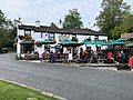
In the present day, tourism is a principal source of income and the village is popular with visitors of all kinds, particularly fell-walkers due to its proximity to many of the Lake Districts most popular fells. The village is home to a plethora of holiday homes, as well as the Britannia Inn and Elterwater Hostel, a former YHA hostel, that was saved from closure and taken independent in 2013. [4]

Art

In the 1880s, the Guild of St George founded by John Ruskin revived small-scale linen spinning and weaving in Langdale, at a cottage in Elterwater, led by Albert Fleming and Marion Twelves and continued by Elizabeth Pepper. [5] The decorative textiles became known as Ruskin Lace. In 1947, German artist Kurt Schwitters created one of his Merzbau in a barn at Cylinders. This three-dimensional artwork, and the entire wall on which it was installed, was moved to the Hatton Gallery in Newcastle in 1965. Artist Bernard Eyre-Walker lived and painted in Elterwater in the 1930s and 40s. Watercolour painter Thomas Frederick Worrall's painting Elterwater Tarn and Langdale Pikes is in the Bishop of Carlisle's house in Keswick.

Only a quarter of the houses in Elterwater are permanently occupied, the rest being holiday cottages. [6]

Etymology

" 'The lake frequented by swans', from ON 'elptr'/'alpt' 'swan', in the gen.[itive], sing.[ular] form with '-ar', and 'water', probably replacing ON 'vatn' 'lake'. Whooper swans still winter on the lake". [7] (ON is Old Norse).

Related Research Articles

<span class="mw-page-title-main">Lake District</span> Mountainous region and national park in North West England

The Lake District, also known as the Lakes or Lakeland, is a mountainous region and national park in Cumbria, North West England. It is famous for its landscape, including its lakes, coast, and the Cumbrian mountains; and for its literary associations with Beatrix Potter, John Ruskin, and the Lake Poets.

<span class="mw-page-title-main">Coniston Water</span> Lake in Cumbria, England

Coniston Water is a lake in the Lake District in North West England. It is the third largest by volume, after Windermere and Ullswater, and the fifth-largest by area. The lake has a length of 8.7 kilometres, a maximum width of 730 metres (800 yd), and a maximum depth of 56.1 m. Its outflow is the River Crake, which drains into Morecambe Bay via the estuary of the River Leven. The lake is in the unitary authority of Westmorland and Furness, and the ceremonial county of Cumbria.

<span class="mw-page-title-main">Grasmere (village)</span> Village in Cumbria, England

Grasmere is a village and former civil parish, now in the parish of Lakes, in the Westmorland and Furness district of Cumbria, England, and situated in the centre of the Lake District and named after its adjacent lake. Grasmere lies within the historic county of Westmorland. The Ambleside and Grasmere ward had an estimated population of 4,592 in 2019. William and Dorothy Wordsworth, the 'Lake Poets', lived in Grasmere for 14 years and called it "the loveliest spot that man hath ever found."

<span class="mw-page-title-main">Cumbria Way</span> Long-distance footpath in Cumbria, England

The Cumbria Way is a linear 112-kilometre (70-mile) long-distance footpath in Cumbria, England. The majority of the route is inside the boundaries of the Lake District National Park. Linking the two historic Cumbrian towns of Ulverston and Carlisle, it passes through the towns of Coniston and Keswick. The route cuts through Lakeland country via Coniston Water, Langdale, Borrowdale, Derwent Water, Skiddaw Forest and Caldbeck. It is a primarily low-level route with some high-level exposed sections.

<span class="mw-page-title-main">Langdale axe industry</span> Stone tool manufacturing

The Langdale axe industry is the name given by archaeologists to a Neolithic centre of specialised stone tool production in the Great Langdale area of the English Lake District. The existence of the site, which dates from around 4,000–3,500 BC, was suggested by chance discoveries in the 1930s. More systematic investigations were undertaken by Clare Fell and others in the 1940s and 1950s, since when several field surveys of varying scope have been carried out.

<span class="mw-page-title-main">Crinkle Crags</span> Mountain in the English Lake District, Cumbria, England

Crinkle Crags is a fell in the English Lake District in the county of Cumbria. It forms part of two major rings of mountains, surrounding the valleys of Great Langdale and Upper Eskdale. The name reflects the fell's physical appearance as its summit ridge is a series of five rises and depressions (crinkles) that are very distinctive from the valley floor. In Old English, cringol means twisted or wrinkled.

<span class="mw-page-title-main">Duddon Valley</span>

The Duddon Valley is a valley in the southern Lake District National Park in Cumbria, England. The River Duddon flows through the valley, rising in the mountains between Eskdale and Langdale, before flowing into the Irish Sea near Broughton in Furness. In its lower reaches it is bounded by the Furness Fells and Harter Fell.

<span class="mw-page-title-main">Great Langdale</span> Valley in Cumbria, England

Great Langdale is a valley in the Lake District National Park in North West England, the epithet "Great" distinguishing it from the neighbouring valley of Little Langdale. Langdale is also the name of a valley in the Howgill Fells, elsewhere in Cumbria.

<span class="mw-page-title-main">Loft Crag</span> Mountain in the English Lake District, Cumbria, England

Loft Crag is a fell in the English Lake District, situated nine kilometres west of Ambleside in the valley of Great Langdale. Along with the neighbouring fells of Harrison Stickle and Pike of Stickle it forms the picturesque Langdale Pikes, which when viewed from the area around Elterwater village gives one of the best-known views in the National Park.

<span class="mw-page-title-main">Pike o' Blisco</span> Mountain in the English Lake District, Cumbria, England

Pike o' Blisco, or Pike of Blisco, is a mountain in the Lake District in Cumbria, England. Located between the valleys of Great Langdale and Little Langdale, its relative isolation from neighbouring fells together with slopes falling away immediately from the summit in all directions mean it has excellent views: the view of the Langdale Pikes across Great Langdale is particularly arresting.

<span class="mw-page-title-main">Coniston, Cumbria</span> Village and parish in England

Coniston is a village and civil parish in the Westmorland and Furness district of Cumbria, England. In the 2001 census the parish had a population of 1,058, decreasing at the 2011 census to 928. Within the boundaries of the historic county of Lancashire, it is in the southern part of the Lake District National Park, between Coniston Water, the third longest lake in the Lake District, and Coniston Old Man.

<span class="mw-page-title-main">Elter Water</span> Lake in Cumbria, England

Elter Water is a small lake in the Lake District in North West England, half a mile southeast of the village of the same name. It has a length of 0.62 miles (1.00 km), maximum width of approximately 0.24 miles (0.39 km), a maximum depth of 7 metres (7.7 yd), and an area of 0.16 square kilometres (0.062 sq mi). Its outflow is the River Brathay, which flows south to join Windermere near Ambleside. Windermere is itself drained by the River Leven, which flows into Morecambe Bay. The lake is in the unitary authority of Westmorland and Furness and the ceremonial county of Cumbria.

Thomas William Birkett better known as Bill Birkett is an English civil engineer, climbing writer, photographer, rock climber, and mountaineer, from the Lake District, Cumbria, who has undertaken many expeditions around the world. The 541 peaks of the lake district listed in one of his books are known as Birketts in his honor.

<span class="mw-page-title-main">Rydal Water</span> A lake in Cumbria, England

Rydal Water is a small body of water in the central part of the English Lake District, in the county of Cumbria. It is located near the hamlet of Rydal, between Grasmere and Ambleside in the Rothay Valley.

<span class="mw-page-title-main">Boot, Cumbria</span> Human settlement in England

Boot is a small village in Eskdale, Cumbria, in the Lake District of England. It forms part of the Borough of Copeland.

<span class="mw-page-title-main">Silver How</span> Fell in the Lake District, Cumbria, England

Silver How is a fell in the English Lake District, standing over the village of Grasmere. How, derived from the Old Norse word haugr, is a common local term for a hill or mound.

<span class="mw-page-title-main">Lingmoor Fell</span> Fell in the Lake District, Cumbria, England

Lingmoor Fell is a fell in the English Lake District, situated eight kilometres west of Ambleside. The fell reaches a height of 469 m (1,540 ft) and divides the valleys of Great Langdale and Little Langdale. The fell's name originates from the Old Norse word lyng meaning “heather covered”. The actual summit of the fell is named as Brown How on Ordnance Survey maps.

<span class="mw-page-title-main">Grasmere (lake)</span> Lake in Cumbria, England

Grasmere is one of the smaller lakes of the English Lake District, in the county of Cumbria. It gives its name to the village of Grasmere, famously associated with the poet William Wordsworth and his sister Dorothy Wordsworth, which is immediately to the north of the lake.

The Central Fells are a part of the Cumbrian Mountains in the Lake District of England. Reaching their highest point at High Raise, they occupy a broad area to the east of Borrowdale. The Central Fells are generally lower than the surrounding hills, the Lake District's dome-like structure having a slight dip in the middle. The range extends from the boggy ridge between Derwentwater and Thirlmere in the north, to the rock peaks of the Langdale Pikes in the south.

<span class="mw-page-title-main">Little Langdale</span> Valley in the Lake District, England

Little Langdale is a valley in the Lake District, England, containing Little Langdale Tarn and a hamlet also called Little Langdale. A second tarn, Blea Tarn, is in a hanging valley between Little Langdale and the larger Great Langdale to the north. Little Langdale is flanked on the south and southwest by Wetherlam and Swirl How, and to the north and northwest by Lingmoor Fell and Pike of Blisco. The valley descends to join with Great Langdale above Elter Water.

References

  1. Parker, John (2002). An Atlas of the English Lakes: Pictorial Charts Compiled from an Exploration of the Shorelines of the Lake District on Foot and by Canoe. Cicerone. p. 37. ISBN   1852843551.
  2. Elterwater Bridge, LakesHistoric England
  3. Jecock, Marcus, "Elterwater Gunpowder Works, Cumbria: an archaeological and historical survey". English Heritage Report Series AI/9/2003, 2003.
  4. "Closure and sale of two youth hostels is a 'crying shame' after decades of welcoming old and young alike". Westmorland Gazette. 25 April 2013.
  5. Brunton, Jennie, "The Arts and Crafts Movement in the Lake District". Centre for North West Regional Studies, 2001, pp 57-86.
  6. "Elterwater - Visit Cumbria". www.visitcumbria.com.
  7. Whaley, Diana (2006). A dictionary of Lake District place-names. Nottingham: English Place-Name Society. pp. lx, 423 p.108–109. ISBN   0904889726.

Bibliography

Commons-logo.svg Media related to Elterwater at Wikimedia Commons