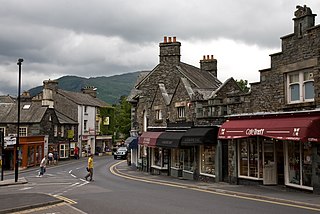
Ambleside is a town and former civil parish in the Westmorland and Furness district of Cumbria, England. Within the boundaries of the historic county of Westmorland and located in the Lake District National Park, the town sits at the head of Windermere, England's largest natural lake. In 2020 it had an estimated population of 2596.

Lakeside is a village in Newby Bridge at the south end of Windermere, England. Now in the county of Cumbria, before county reorganisation of 1974 it was in Lancashire, as part of the region known as Furness. It was established as a steamer pier for services along the lake when the Lakeside branch of the Furness Railway reached it in 1869, meaning that steamer services no longer had to negotiate the River Leven to Newby Bridge. Also built at Lakeside was a hotel to serve the tourists brought by the railway and steamers.

Great Langdale is a valley in the Lake District National Park in North West England, the epithet, "Great" distinguishing it from the neighbouring valley of Little Langdale. Langdale is also the name of a valley in the Howgill Fells, elsewhere in Cumbria.

Newby Bridge is a small hamlet in the Lake District, Cumbria, England. Historically in Lancashire, it is located several miles west of Grange-over-Sands and is on the River Leven, close to the southern end of Windermere.
Lindale - traditionally Lindale in Cartmel - is a village in the south of Cumbria. It lies on the north-eastern side of Morecambe Bay, England. It was part of Lancashire from 1182 to 1974. It is in the civil parish of Lindale and Newton-in-Cartmel, in South Lakeland district.

Barton is a hamlet in the civil parish of Barton and Pooley Bridge, in Eden District, Cumbria, England. It lies about 3 kilometres (1.9 mi) to the north east of Pooley Bridge, east of the River Eamont and west of the B5320 road from Pooley Bridge to Eamont Bridge. The parish, which includes Barton and the larger settlement of Pooley Bridge, was renamed from "Barton" to "Barton and Pooley Bridge" on 1 April 2019, and had a population of 238 at the 2011 Census.

Elter Water is a small lake in the Lake District in North West England, half a mile southeast of the village of the same name. It has a length of 0.62 miles (1.00 km), maximum width of approximately 0.24 miles (0.39 km), a maximum depth of 7 metres (7.7 yd), and an area of 0.16 square kilometres (0.062 sq mi). Its outflow is the River Brathay, which flows south to join Windermere near Ambleside. Windermere is itself drained by the River Leven, which flows into Morecambe Bay. The lake is in the unitary authority of Westmorland and Furness and the ceremonial county of Cumbria.

The River Irt is a river in the county of Cumbria in northern England. It flows for 14 miles (22 km) from the south-western end of Wast Water, the deepest lake in England, leaving the lake at the foot of Whin Rigg, the southern peak of the famous Wastwater Screes. The name of the river is believed to derive either from the Old English gyr which means "mud", or from the Brittonic words *ar, "flowing", or *īr, "fresh, clean, pure", suffixed with -ed, a nominal suffix meaning "having the quality of...".

Lingmoor Fell is a fell in the English Lake District, situated eight kilometres west of Ambleside. The fell reaches a height of 469 m (1,540 ft) and divides the valleys of Great Langdale and Little Langdale. The fell's name originates from the Old Norse word lyng meaning “heather covered”. The actual summit of the fell is named as Brown How on Ordnance Survey maps.

Mungrisdale is a small village and civil parish in the north east of the English Lake District in Cumbria. It is also the name of the valley in which the village sits. Mungrisdale is a popular starting point for ascents of the nearby hills, such as Bowscale Fell, Bannerdale Crags and Souther Fell. It lies on the River Glenderamackin, a tributary of the Greta.

Skelwith Bridge is a small village in the southern area of the Lake District in Cumbria, England. Historically, Skelwith Bridge is part of Westmorland, lying on the ancient boundary with Lancashire. The civil parish is called Skelwith. Its population at the 2011 census was 155. It is located around 3 miles south of Grasmere and is nearby the waterfalls of Skelwith Force and Colwith Force. The nearest lakes to the village are Elter Water to the north-west and Loughrigg Tarn to the north.

Colton is a village and civil parish in the South Lakeland district of Cumbria, England. In the 2001 census the parish had a population of 765, decreasing at the 2011 census to 672. It was historically part of Lancashire. Its name has been recorded as Coleton and Coulton, and its existence has been recorded as early as 1202.

Calder Bridge is a small village in Cumbria in England. It is located between the hamlets of Gosforth and Beckermet and lies on the River Calder.

Howtown is a hamlet in Cumbria, England, situated at a small harbour on the east shore of Ullswater in the Lake District. It lies within the civil parish of Martindale.

Elterwater is a village in the English Lake District and the county of Cumbria. The village lies half a mile north-west of the lake of Elter Water, from which it derives its name. Both are situated in the valley of Great Langdale.

Grange, often called Grange in Borrowdale, is a village in Borrowdale in the English Lake District. It lies just off the B5289 road to the south of Derwent Water and 4 miles (6.4 km) south of Keswick, in the county of Cumbria, historically part of Cumberland,

Low Newton is a hamlet in the South Lakeland District, in the county of Cumbria, England and in the Lake District also commonly known as The Lakes. It was on the A590 road until along with its neighbour High Newton a bypass was built, opening on Tuesday 8 April 2008.
Ennerdale and Kinniside is a civil parish in Copeland, Cumbria, England. At the 2011 census it had a population of 220.
Barton and Pooley Bridge is a civil parish in Eden District, Cumbria, England. The parish is on the edge of the Lake District National Park, and had a population of 232 according to the 2001 census, increasing slightly to 238 at the 2011 Census. The parish includes the village of Pooley Bridge, the small hamlet of Barton, and part of Ullswater, and extends south as far as Loadpot Hill. It has an area of 16.95 square kilometres (6.54 sq mi) and a 2011 population density of 14/sqkm (36/sqmi). The parish was renamed from "Barton" to "Barton and Pooley Bridge" on 1 April 2019.

