Haweswater Reservoir

Last updated

Haweswater Reservoir
Haweswater from Harter Fell 3.jpg
Reservoir seen from Harter Fell, Mardale
Lake District National Park UK relief location map.png
Red pog.svg
Haweswater Reservoir
Location relief map United Kingdom Eden.svg
Red pog.svg
Haweswater Reservoir
Location in Eden, Cumbria
Location Lake District, Cumbria
Coordinates 54°31′08″N2°48′17″W / 54.51889°N 2.80472°W / 54.51889; -2.80472
Type reservoir, natural lake
Primary inflows Mardale Beck, Riggindale Beck
Primary outflows Haweswater Beck
Basin  countriesEngland
Max. length6.7 km (4.2 mi) [1]
Max. width900 m (3,000 ft) [1]
Surface area3.9 km2 (1.5 sq mi) [1]
Average depth23.4 m (77 ft) [1]
Max. depth57 m (187 ft) [1]
Water volume84 billion litres (18×10^9 imp gal)
Residence time 500 days [1]
Surface elevation246 m (807 ft)
Islands 1
References [1]

Haweswater is a reservoir in the valley of Mardale, Cumbria in the Lake District, England. Work to raise the height of the original natural lake was started in 1929. It was controversially dammed after the UK Parliament passed a Private Act giving Manchester Corporation permission to build the reservoir to supply drinking water to the city. The decision caused a public outcry because the farming villages of Measand and Mardale Green would be flooded and the valley altered forever.

Contents

The reservoir is now owned by United Utilities. It supplies about 25% of the North West's water supply.

Etymology

Haweswater is derived from Old Norse or Old English. 'Hafr's lake' refers to the personal Norse name 'Hafr' or in Old English 'Hæfer'; 'water' or 'wæter' is the dominant term for 'lake' in old English. [2]

Geology

Haweswater is the location of a caldera volcano succession. [3]

History

Parapet atop the Haweswater Reservoir Haweswater Reservoir dam.jpg
Parapet atop the Haweswater Reservoir

Haweswater was originally a natural lake about 4 km (2.5 mi) long. A tongue of land at Measand divided the lake almost in two. The upper and lower reaches of the lake were known as High Water and Low Water.

In 1929 work started to build the dam wall across the valley floor. At the time of construction, its design was considered to be at the forefront of civil engineering technology because it was the world's first hollow buttress dam. The wall would be created from 44 separate buttressed units joined by flexible joints. When the dam was completed by 1935, it measured 470 m (1,540 ft) long and 27.5 m (90 ft) high. It has a 1.4 m (4 ft 7 in) wide parapet that runs atop the length of the dam. Building supplies were brought to the site from the adjoining valleys of Heltondale and Swindale. When the valley was flooded, the dam raised the water level by 29 m (95 ft). This created a reservoir 6 km (3.7 mi) long and up to 600 m (2,000 ft) across at its widest point. It holds up to 84 billion litres (18×10^9 imp gal) of water.

1924 map of Haweswater before it was enlarged. Note Mardale Green and the original road on the west bank. Hawes Water 1924 Map.jpg
1924 map of Haweswater before it was enlarged. Note Mardale Green and the original road on the west bank.
1930s Manchester Corporation Water Works (MCWW) footpath sign at the western end car park Haweswater Mcr Corpn Water Works Sign 1930s.jpg
1930s Manchester Corporation Water Works (MCWW) footpath sign at the western end car park

Before the valley was flooded in 1935, all the farms and dwellings of the villages of Mardale Green and Measand were demolished, as well as the centuries-old Dun Bull Inn at Mardale Green. The village church was dismantled and the stone used in constructing the dam; all the bodies in the churchyard were exhumed and re-buried at Shap.

Today, when the water in the reservoir is low, the remains of the submerged village of Mardale Green can still be seen, including stone walls and the village bridge. [4]

Manchester Corporation built a new road along the eastern side of the lake to replace the flooded highway lower in the valley, and the Haweswater Hotel was constructed midway down the length of the reservoir as a replacement for the Dun Bull. The road continues to the western end of Haweswater, to a car park, a popular starting point for a path to the surrounding fells of Harter Fell, Branstree and High Street.

Wildlife

A map of Haweswater Reservoir from 1948 Haweswater Reservoirmap 1948.png
A map of Haweswater Reservoir from 1948

Fish

There is a population of schelly fish in the lake, believed to have lived there since the last Ice Age.

The RSPB at Haweswater

The Royal Society for the Protection of Birds (RSPB) first became involved at Haweswater, because of the presence of golden eagles - the first to return to England in over 170 years. The organisation currently leases two farms in the area and has rights to their associated common land

Until 2015, Haweswater was the only place in England where a golden eagle was resident. A pair of eagles first nested in the valley of Riggindale in 1969, and the male and female of the pairing changed several times over the years, during which 16 chicks were produced. The last female bird disappeared in April 2004, leaving the male alone. [5] There was an RSPB viewpoint in the valley for people wishing to see the eagle. The last sighting was in November 2015. It was reported in 2016 that the 20-year old bird may have died of natural causes. [6]

Since 2012, the RSPB has leased two farms from the landowner United Utilities. [7] [8] The aim is to combine the improvement of wildlife habitats and water quality with running a viable sheep farm. Moorland and woodland habitats are being improved for a whole host of plants and trees, birds, insects and mammals.

The RSPB have established the largest native tree and plant nursery in the Lake District. Here the staff and volunteers gather seed from the existing plants and trees on-site, grow it on in the nursery and plant it back out to restore the landscape.

Literary references

Lee Schofield, the RSPB's Site Manager at Haweswater, has published Wild Fell: Fighting for Nature on a Lake District Hill Farm (2022, Penguin: ISBN   978-0-8575-2775-2), his personal account of the RSPB's work at the site. The book was Highly Commended in the James Cropper Wainwright Prize Writing on Conservation 2022 and Winner of the Richard Jefferies Award in 2023.

Lake District writer and fell walker Alfred Wainwright had this to say on the construction of the Haweswater Dam in his 1955 book A Pictorial Guide to the Lakeland Fells :

If we can accept as absolutely necessary the conversion of Haweswater [to a reservoir], then it must be conceded that Manchester have done the job as unobtrusively as possible. Mardale is still a noble valley. But man works with such clumsy hands! Gone for ever are the quiet wooded bays and shingly shores that nature had fashioned so sweetly in the Haweswater of old; how aggressively ugly is the tidemark of the new Haweswater! [9]

Haweswater is a 2002 novel by British writer Sarah Hall, set in Mardale at the time of the building of the dam and flooding of the valley. [10] It won the 2003 Commonwealth Writers' Prize for a First book. [11] The novel was released in the United States as a paperback original in October 2006, by Harper Perennial.

Hawes Water is described in Anthony Trollope's novel Can You Forgive Her? (1864).[ citation needed ]

Related Research Articles

<span class="mw-page-title-main">Lake District</span> Mountainous region and national park in North West England

The Lake District, also known as the Lakes or Lakeland, is a mountainous region and national park in North West England. It is primarily famous for its mountain, lake, and coastal scenery, and for its literary associations with William Wordsworth and other Lake Poets, Beatrix Potter, and John Ruskin.

<span class="mw-page-title-main">Lake Vyrnwy</span> Man-made lake in Wales

Lake Vyrnwy is a reservoir in Powys, Wales, built in the 1880s for Liverpool Corporation Waterworks to supply Liverpool with fresh water. It flooded the head of the Vyrnwy valley and submerged the village of Llanwddyn.
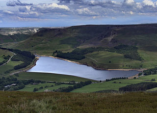
<span class="mw-page-title-main">Longsleddale</span> Valley and civil parish in Cumbria, England

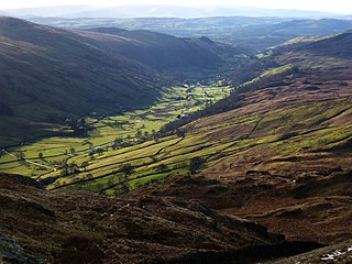
Longsleddale is a valley and civil parish in the South Lakeland district of Cumbria, England. It includes the hamlet of Sadgill. The parish has a population of 73. As the population taken at the 2011 Census was less than 100, details are maintained in the civil parish of Whitwell and Selside.

<span class="mw-page-title-main">High Street (Lake District)</span> Mountain in Cumbria, England

High Street is a fell in the English Lake District. At 828 metres (2,717 ft), its summit is the highest point in the far eastern part of the national park. The fell is named after the Roman road that ran over the summit.

<span class="mw-page-title-main">Harter Fell (Mardale)</span> Mountain in United Kingdom

Harter Fell is a fell in the far eastern part of the English Lake District. The summit at lies the meeting point of three ridges, and Harter Fell forms the head of three valleys: Mardale, Longsleddale and the valley of the River Kent.

<span class="mw-page-title-main">Branstree</span> Fell in the Lake District, Cumbria, England

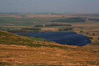
Branstree is a fell in the Far Eastern part of the English Lake District. It overlooks the valley of Mardale and Haweswater Reservoir.

<span class="mw-page-title-main">Shap Rural</span> Civil parish in England

Shap Rural is a very large, but sparsely populated, civil parish in the Eden district of Cumbria in England, covering part of the Lake District National Park. It had a population of 119 in 2001, increasing to 130 at the 2011 Census.

<span class="mw-page-title-main">Wether Hill (Lake District)</span> Fell in the Lake District, Cumbria, England

Wether Hill is a fell in the English Lake District, between Martindale and Haweswater. It lies on the main north-south ridge of the Far Eastern Fells between Loadpot Hill and High Raise. Lesser ridges also radiate out to the east and north-west.

<span class="mw-page-title-main">High Raise (High Street)</span> Mountain in the English Lake District, Cumbria, England

High Raise is a fell in the English Lake District, standing to the west of Haweswater Reservoir in the Far Eastern Fells. Note that another High Raise is the highpoint of the Central Fells.

<span class="mw-page-title-main">Rampsgill Head</span> Fell in the Lake District, Cumbria, England

Rampsgill Head is a fell in the English Lake District, standing to the west of Haweswater Reservoir in the Far Eastern Fells. It forms the focal point of three ridges which fan out north-east, north-west and south.

<span class="mw-page-title-main">Kidsty Pike</span>

Kidsty Pike is a fell in the English Lake District, standing to the west of Haweswater Reservoir. It is a subsidiary top of Rampsgill Head, but has long achieved the status of a separate fell, thanks to its classic peaked profile. Wainwright followed this convention in his Pictorial Guide to the Lakeland Fells.

<span class="mw-page-title-main">Mardale Ill Bell</span>

Mardale Ill Bell is a fell in the English Lake District, rising to the south west of Haweswater Reservoir. It stands on the watershed between Mardale and Kentmere and is the highpoint of the south-eastern ridge of High Street, midway on its course to Harter Fell.

Selside Pike or Selside is a fell in the English Lake District. It stands between the valleys of Mardale and Swindale in the Far Eastern Fells.

<span class="mw-page-title-main">Tarn Crag (Far Eastern Fells)</span> Fell in the Lake District, Cumbria, England

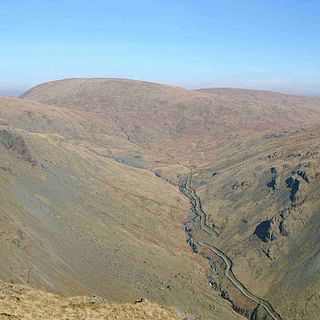
Tarn Crag is a fell in the English Lake District. It stands to the east of Longsleddale in the Far Eastern Fells.

<span class="mw-page-title-main">Grey Crag</span> Fell in the Lake District, Cumbria, England

Grey Crag is a fell in the English Lake District. It stands to the east of Longsleddale in the Far Eastern Fells.

<span class="mw-page-title-main">Brim Fell</span> Fell in the Lake District, Cumbria, England

Brim Fell is a fell in the English Lake District. It stands to the west of Coniston village in the southern part of the District.

<span class="mw-page-title-main">Far Eastern Fells</span> Mountain range in Cumbria, England

The Far Eastern Fells are a group of hills in the English Lake District. Reaching their highest point at High Street, they occupy a broad area to the east of Ullswater and Kirkstone Pass. Much quieter than the central areas of Lakeland they offer in general easier walking as the fells merge mainly into the surrounding moorlands.

<span class="mw-page-title-main">Wet Sleddale Reservoir</span> Reservoir in Shap, Cumbria

Wet Sleddale Reservoir is an artificial reservoir set amongst the Shap Fells 4 kilometres (2 mi) south of the village of Shap in Cumbria, England, and lies just within the boundary of the Lake District National Park. The triangular shaped reservoir, which can store 2,300 million litres of water, was created by the construction of a dam across Sleddale Beck in order to supply Manchester with water. The dam is 21m high and 600m long.

Lee Schofield is a British conservationist and author. He wrote Wild Fell: Fighting for Nature on a Lake District Hill Farm, which chronicles a decade of working as site manager for the RSPB at Haweswater in the Lake District National Park.

References

  1. 1 2 3 4 5 6 7 McNamara, Jane, Table of lake facts, Environment Agency of England and Wales, archived from the original on 28 June 2009, retrieved 13 November 2007
  2. Whaley, Diana (2006). A dictionary of Lake District place-names. Nottingham: English Place-Name Society. pp. lx, 157, 422, 423. ISBN   0904889726.
  3. Brenchley, P. J. (10 January 2006). The Geology of England and Wales. Geological Society of London. ISBN   9781862392007 . Retrieved 10 January 2023 via Google Books.
  4. "Lake District village ruins revealed by water shortage". BBC News. 18 July 2018.
  5. "Haweswater". RSPB website. Retrieved 4 March 2007.
  6. Aldred, Jessica (2016). "England's last Golden Eagle feared dead". TheGuardian.com . Retrieved 26 May 2016.
  7. "RSPB turns to farming". Westmorland Gazette.
  8. "New deal for nature and water". 2012.
  9. Wainwright, A (2005). A pictorial guide to the Lakeland fells. Vol. Book 2: The far Eastern fells (2nd ed. revised by Chris Jesty ed.). London: Frances Lincoln. pp. n.p. "Some personal notes in conclusion". ISBN   9780711224667.
  10. Falconer, Helen (14 June 2002). "Village of the dammed". The Guardian. Retrieved 28 May 2023.
  11. "Commonwealth Writers' Prize Regional Winners 1987–2007" (PDF). Commonwealth Foundation. Archived from the original (PDF) on 23 October 2007.

Commons-logo.svg Media related to Haweswater Reservoir at Wikimedia Commons