Hawes Water (Silverdale)

Last updated

Hawes Water
Hawes Water, near Silverdale - geograph.org.uk - 13979.jpg
Looking across the lake towards Challon Hall
Lancashire UK relief location map.jpg
Red pog.svg
Hawes Water
Location in Lancashire
Location map United Kingdom City of Lancaster.svg
Red pog.svg
Hawes Water
Location in City of Lancaster district
Location Silverdale, Lancashire, England
Coordinates 54°10′58″N2°48′06″W / 54.182640°N 2.801607°W / 54.182640; -2.801607
Type natural lake
Primary outflows Hawes Water Moss, Myers Dyke, into Morecambe Bay
Catchment area 1.7 square kilometres (0.66 sq mi) [1]
Basin  countriesEngland
Max. length400 m (1,300 ft) [1]
Max. width225 m (738 ft) [1]
Surface area5.7 hectares (14 acres) [2]
Max. depth12 m (39 ft) [1]
Residence time 0.32 years [2]

Hawes Water, sometimes called Hawes Tarn, [3] is a lake in north west Lancashire, England, in the parish of Silverdale, the Arnside and Silverdale AONB, and the Gait Barrows National Nature Reserve (NNR). [4] It is one of only two natural fresh-water lakes in the county, along with Marton Mere. It is a marl lake and the focus of an eponymous Site of Special Scientific Interest (SSSI) [5] and has been the subject of several research studies. [1] [2] [6] [7] Little Hawes Water is a smaller lake to the north east. To the south of the lake, and included in the SSSI, is the area of Haweswater Moss. [8]

Contents

The footpath along the eastern side of Hawes Water is accessible for wheelchairs, and a car parking place is provided which can be accessed with a RADAR key. [9]

Fiona Reynolds, writing in Country Life , described Hawes Water as "a mysterious, low-lying marl lake, where ... we are told of riches, bitterns and lady's slipper orchid, that can be seen when the time is right". [10]

It has been recorded that a serpent was believed to live in the lake, emerging occasionally to devour local sheep. [3]

In 2020 Natural England published a Summary guide to the management of Gait Barrows National Nature Reserve, Silverdale, Lancashire 2020–2025 [11] and a Grazed Habitats Management Plan: Gait Barrows National Nature Reserve 2020-2025 [12] describing their plans for Hawes Water and the rest of the Gait Barrows NNR.

Related Research Articles

<span class="mw-page-title-main">Marl</span> Lime-rich mud or mudstone which contains variable amounts of clays and silt

Marl is an earthy material rich in carbonate minerals, clays, and silt. When hardened into rock, this becomes marlstone. It is formed in marine or freshwater environments, often through the activities of algae.

<span class="mw-page-title-main">National nature reserves in England</span>

National nature reserves in England are designated by Natural England as key places for wildlife and natural features in England. They were established to protect the most significant areas of habitat and of geological formations. NNRs are managed on behalf of the nation, many by Natural England itself, but also by non-governmental organisations, including the members of The Wildlife Trusts partnership, the National Trust, and the Royal Society for the Protection of Birds.

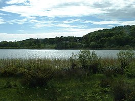
National nature reserves in Lancashire in England are established by Natural England.

<span class="mw-page-title-main">Arnside</span> Human settlement in England

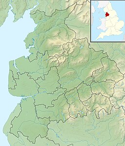
Arnside is a village and civil parish in Cumbria, historically part of Westmorland, near the border with Lancashire, England. The Lake District National Park is located a few miles north. Travelling by road, Arnside is 22 miles (35 km) to the south of Kendal, 25.3 miles (40.7 km) to the east of Ulverston, 35.2 miles (56.6 km) to the east of Barrow-in-Furness, 15.7 miles (25.3 km) to the west of Lancaster and 14.3 miles (23.0 km) to the east of Grange-over-Sands. In the 2001 census the parish had a population of 2,301, increasing at the 2011 census to 2,334.

<span class="mw-page-title-main">Insh Marshes</span>

Insh Marshes are an area of floodplain of the River Spey between Kingussie and Kincraig in Badenoch and Strathspey, Highland, Scotland. The marshes are said to be one of the most important wetlands in Europe. They lie at altitude of approximately 240 to 220 m above sea level, and form one of the largest areas of floodplain mire and fen vegetation in Scotland.

<span class="mw-page-title-main">Silverdale, Lancashire</span> Village in Lancashire, England

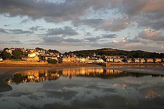
Silverdale is a village and civil parish within the City of Lancaster district of Lancashire, England. The village stands on Morecambe Bay, near the border with Cumbria, 4.5 miles (7 km) north west of Carnforth and 8.5 miles (14 km) of Lancaster. The parish had a population of 1,519 recorded in the 2011 census.

<span class="mw-page-title-main">Yealand Redmayne</span> Human settlement in England

Yealand Redmayne is a village and civil parish in the English county of Lancashire.

<span class="mw-page-title-main">Arnside and Silverdale</span> Area of Outstanding Natural Beauty in England

Arnside and Silverdale is an Area of Outstanding Natural Beauty in England, on the border between Lancashire and Cumbria, adjoining Morecambe Bay. One of the smallest AONBs, it covers 29 square miles (75 km2) between the Kent Estuary, the River Keer and the A6 road. It was designated in 1972.

<span class="mw-page-title-main">Warton Crag</span> Hill near Warton, Lancaster, Lancashire, UK

Warton Crag is a limestone hill in north west Lancashire, England. It lies to the north west of Warton village, in City of Lancaster district. At 163 metres (535 ft) it is the highest point in the Arnside and Silverdale Area of Outstanding Natural Beauty, and is listed as a "HuMP" or "Hundred Metre Prominence", having a "drop" or "prominence" of 126 metres (413 ft) with its parent being Hutton Roof Crags. Two areas are Local Nature Reserves, called Warton Crag and Warton Crag Quarry. Different sections are owned by Lancashire County Council, the Wildlife Trust for Lancashire, Manchester and North Merseyside, Lancaster City Council and the Royal Society for the Protection of Birds.

<span class="mw-page-title-main">Hazelwood Hall</span> English country house in Lancashire, England

Hazelwood Hall, sometimes spelt Hazlewood, is a nineteenth-century country house set in 18.5 acres of woodland and gardens in the village of Silverdale, Lancashire, England, 8.5 miles (13.7 km) north of Lancaster. The building was converted into holiday flats in 2006.

<span class="mw-page-title-main">Nature reserves in the North Norfolk Coast Site of Special Scientific Interest</span>

The North Norfolk Coast Site of Special Scientific Interest (SSSI) is an internationally important protected area in Norfolk, England. The SSSI is a long, narrow strip of coastal land that starts between Old Hunstanton and Holme-next-the-Sea, and runs east for about 43 km (27 mi) to Kelling. The southern boundary runs roughly west to east except where it detours around towns and villages, and never crosses the A149 coast road. It has an area of 7,700 ha (19,027 acres), and is additionally protected through Natura 2000, Special Protection Area (SPA) and Ramsar listings; it is also part of the Norfolk Coast Area of Outstanding Natural Beauty (AONB). Scolt Head Island and the coast from the Holkham National Nature Reserve to Salthouse are a Biosphere Reserve.

<span class="mw-page-title-main">Upper Wye Gorge</span>

Upper Wye Gorge is a Site of Special Scientific Interest (SSSI), noted for its biological and geological characteristics, around Symonds Yat in the Wye Valley on the Wales–England border. The site is listed in the 'Forest of Dean Local Plan Review' as a Key Wildlife Site (KWS).

<span class="mw-page-title-main">Hog Cliff</span>

Hog Cliff is a national nature reserve (NNR) and Site of Special Scientific Interest (SSSI) located 2 kilometres (1.2 mi) south east of Maiden Newton, Dorset and north-west of Dorchester. It was notified as an SSSI in 1981. The site is also part of the much larger Dorset Area of Outstanding Natural Beauty (AONB). It is adjacent to the Court Farm, Sydling SSSI.

<span class="mw-page-title-main">Trowbarrow Quarry</span>

Trowbarrow Quarry is a disused limestone quarry near Silverdale, Lancashire, England, which is a geological Site of Special Scientific Interest and a Local Nature Reserve. It is a popular rock climbing area.

<span class="mw-page-title-main">Stodmarsh SSSI</span>

Stodmarsh SSSI is a 623.2-hectare (1,540-acre) biological Site of Special Scientific Interest near Stodmarsh, north-east of Canterbury in Kent. Parts of it are a Nature Conservation Review site, Grade I, a National Nature Reserve, a Ramsar internationally important wetland site, a Special Area of Conservation and a Special Protection Area under the European Union Directive on the Conservation of Wild Birds.

References

  1. 1 2 3 4 5 Jones, R.T.; Marshall, J.D.; Fisher, E.; Hatton, J.; Patrick, C.; Anderson, K.; Lang, B.; Bedford, A.; Oldfield, F. (November 2011). "Controls on lake level in the early to mid Holocene, Hawes Water, Lancashire, UK". The Holocene. 21 (7): 1061–1072. doi:10.1177/0959683611400455.
  2. 1 2 3 Wiik, Emma; Bennion, Helen; Sayer, Carl D.; Davidson, Thomas A.; McGowan, Suzanne; Patmore, Ian R.; Clarke, Stewart J. (November 2015). "Ecological sensitivity of marl lakes to nutrient enrichment: evidence from Hawes Water, UK". Freshwater Biology. 60 (11): 2226–2247. doi: 10.1111/fwb.12650 .
  3. 1 2 "Townships: Silverdale", A History of the County of Lancaster, Victoria County History, vol. 8, 1914, pp. 180–182, archived from the original on 3 September 2014, retrieved 16 February 2021
  4. "Gait Barrows National Nature Reserve leaflet - NE418". Natural England. Archived from the original on 2 August 2019. Retrieved 16 February 2021.
  5. "Hawes Water SSSI" (PDF). Natural England. Retrieved 16 February 2021.
  6. Oldfield, Frank (July 1960). "Studies in the post-glacial history of British vegetation: Lowland Lonsdale". New Phytologist. 59 (2): 192–217. doi: 10.1111/j.1469-8137.1960.tb06216.x .
  7. Marshall, Jim D.; Jones, Richard T.; Crowley, Stephen F.; Oldfield, Frank; Nash, Samantha; Bedford, Alan (September 2002). "A high resolution Late-Glacial isotopic record from Hawes Water, Northwest England". Palaeogeography, Palaeoclimatology, Palaeoecology. 185 (1–2): 25–40. doi:10.1016/S0031-0182(02)00422-4.
  8. "Hawes Water Moss, Lancaster - area information, map, walks and more". Ordnance Survey Get Outside. Retrieved 16 February 2021.
  9. "Gait Barrows, Hawes Water". Easy Access Walks (PDF). Arnside and Silverdale AONB. 2007. p. 14. Retrieved 16 February 2021.
  10. Reynolds, Fiona (13 February 2020). "Arnside and Silverdale: A landscape on par with the Lake District in its beauty and significance". Country Life. Archived from the original on 22 October 2020. Retrieved 16 February 2021.
  11. "Summary guide to the management of Gait Barrows National Nature Reserve, Silverdale, Lancashire 2020–2025" (PDF). Natural England. January 2020. Archived (PDF) from the original on 20 September 2020. Retrieved 23 February 2021.
  12. "Grazed Habitats Management Plan: Gait Barrows National Nature Reserve 2020-2025" (PDF). Natural England. January 2020. Archived (PDF) from the original on 20 September 2020. Retrieved 23 February 2021.

Further reading