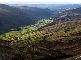
Longsleddale is a valley and civil parish in the South Lakeland district of Cumbria, England. It includes the hamlet of Sadgill. The parish has a population of 73. As the population taken at the 2011 Census was less than 100, details are maintained in the civil parish of Whitwell and Selside.

High Street is a fell in the English Lake District. At 828 metres (2,717 ft), its summit is the highest point in the far eastern part of the national park. The fell is named after the Roman road that ran over the summit.
The Nab is a fell in the English Lake District. It has a moderate height of 576 metres, and lies in the quieter eastern high ground between Ullswater and Haweswater Reservoir. The Nab is included in Alfred Wainwright's list of Lakeland fells and many walkers feel compelled to climb it to complete their list of 'Wainwrights' even though it is not a significant fell and is awkward to reach.

Kirk Fell is a fell in the Western part of the English Lake District. It is situated between Great Gable and Pillar on the long ring of fells surrounding the valley of Ennerdale, and also stands over Wasdale to the south. However, it is separated from its two higher neighbours by the low passes of Black Sail and Beck Head, giving it a high relative height and making it a Marilyn, the thirteenth highest in the Lake District.

Harter Fell is a fell in the far eastern part of the English Lake District. The summit at lies the meeting point of three ridges, and Harter Fell forms the head of three valleys: Mardale, Longsleddale and the valley of the River Kent.

Shipman Knotts is a fell in the English Lake District in Cumbria, England. It reaches a height of 587 metres (1,926 ft) and is situated in one of the quieter areas of the national park, 2 kilometres north-east of Kentmere village. Although not one of the best-known Lake District fells, it earned a separate chapter in Alfred Wainwright’s Pictorial Guide to the Lakeland Fells due to “Its characteristic roughness. .. rocky outcrops are everywhere on its steep slopes”.

Red Pike is a fell in the English Lake District. It is 826 m or 2,709 ft high and lies due north of Wast Water. It is often climbed as part of the Mosedale Horseshoe, a walk which also includes Pillar.

Scoat Fell is a fell in the western part of the English Lake District. It stands at the head of the Mosedale Horseshoe with its back to Ennerdale. Paths lead to Scoat Fell from Ennerdale over Steeple, from Wasdale over Red Pike, and along the ridge from Pillar.

Wether Hill is a fell in the English Lake District, between Martindale and Haweswater. It lies on the main north-south ridge of the Far Eastern Fells between Loadpot Hill and High Raise. Lesser ridges also radiate out to the east and north-west. It should not be confused with Wether Hill in north Northumberland.

High Raise is a fell in the English Lake District, standing to the west of Haweswater Reservoir in the Far Eastern Fells. Note that another High Raise is the highpoint of the Central Fells.

Kidsty Pike is a fell in the English Lake District, standing to the west of Haweswater Reservoir. It is a subsidiary top of Rampsgill Head, but has long achieved the status of a separate fell, thanks to its classic peaked profile. Wainwright followed this convention in his Pictorial Guide to the Lakeland Fells.
Mardale Ill Bell is a fell in the English Lake District, rising to the south west of Haweswater Reservoir. It stands on the watershed between Mardale and Kentmere and is the highpoint of the south-eastern ridge of High Street, midway on its course to Harter Fell.
Selside Pike or Selside is a fell in the English Lake District. It stands between the valleys of Mardale and Swindale in the Far Eastern Fells.

Tarn Crag is a fell in the English Lake District. It stands to the east of Longsleddale in the Far Eastern Fells.

Grey Crag is a fell in the English Lake District. It stands to the east of Longsleddale in the Far Eastern Fells.

Great Carrs is a fell in the English Lake District. It stands above Wrynose Pass in the southern part of the District.
The Far Eastern Fells are a part of the Cumbrian Mountains in the Lake District of England. Reaching their highest point at High Street, they occupy a broad area to the east of Ullswater and Kirkstone Pass. Much quieter than the central areas of Lakeland they offer in general easier walking as the fells merge mainly into the surrounding moorlands.

The Naddle Horseshoe is a group of summits in the English Lake District, south of Mardale valley, Cumbria. It is the subject of a chapter of Wainwright's book The Outlying Fells of Lakeland.
Howes is a subsidiary summit of Branstree in the English Lake District, south east of Selside Pike in Cumbria. It is the subject of a chapter of Wainwright's book The Outlying Fells of Lakeland. Wainwright's route starts at Swindale Head and follows Swindale Beck, then passes over Nabs Moor at 1,613 feet (492 m) to reach the summit of Howes at 1,930 feet (590 m), dropping down to Mosedale Beck to complete an anticlockwise circuit. Wainwright states that Howes is "merely a subsidiary and undistinguished summit on the broad eastern flank of Barnstree. There is nothing exciting about it" but commends the sight of Mosedale quarry and the waterfalls of Swindale Head which he describes as "extremely fine, up to Lodore standard".

