The Nab

Last updated

The Nab
The Nab from Martindale 1.JPG
Seen from Martindale on the lower slopes of Wether Hill. "The Bungalow" is visible in the valley.
Highest point
Elevation 576 m (1,890 ft)
Prominence 61 m (200 ft)
Parent peak Rest Dodd
Listing Wainwright
Coordinates 54°31′44″N2°52′34″W / 54.5289°N 2.87609°W / 54.5289; -2.87609
Geography
Lake District National Park UK relief location map.png
Red triangle with thick white border.svg
The Nab
Location in Lake District, UK
Location Cumbria, England
Parent range Lake District, Far Eastern Fells
OS grid NY434152
Topo map OS Explorer OL5
Looking down into Martindale from the summit of The Nab. Martindale from The Nab 1.JPG
Looking down into Martindale from the summit of The Nab.

The Nab is a fell in the English Lake District. It has a moderate height of 576 metres (1,890 feet), and lies in the quieter eastern high ground between Ullswater and Haweswater Reservoir. The Nab is included in Alfred Wainwright's list of Lakeland fells and many walkers feel compelled to climb it to complete their list of 'Wainwrights' even though it is not a significant fell and is awkward to reach.

Contents

Topography

The Nab is a top on the northern ridge of Rest Dodd, one of the horseshoe of fells surrounding the Martindale catchment. It divides the valleys of Bannerdale and Rampsgill, which meet below the nose of the ridge to form How Grain. The sides of the ridge are steep and rough, but the top is broad and level. It is scarred by peat hags, some deeper than a man.

Access and history

When Alfred Wainwright wrote his pictorial guide to the Far Eastern Fells in the 1950s The Nab, as part of the Martindale Deer Forest was strictly out of bounds. He wrote in the chapter on The Nab:

Keep Out notices, barricaded gates and miles of barbed wire must convey the impression even to the dullest witted walker that there is no welcome here

The Nab is open access under the Countryside and Rights of Way Act 2000 although this is part of the red deer conservation area and this fell is a sanctuary for the animals away from people. Walks here should be avoided particularly during the calving season between May and mid-June. Further advice should be sought from Dalemain Estate to see if walking is possible. Access to the summit is from Dalehead Farm and past Angle Tarn. It is not possible to go through the fields below to the north east of the fell.

Anybody approaching from the north will see 'The Bungalow' in Martindale which was formerly a shooting lodge built in 1910 by the Earl of Lonsdale for the visiting Kaiser Wilhelm and is now a holiday cottage available to rent.

A report from the Department for Environment, Food and Rural Affairs found that Martindale deer may be the only pure blooded Red Deer left in England as many herds become cross bred with genes from the Sika Deer. [1]

Summit

The grassy dome of the summit is marked by a small cairn. Although the view is obstructed by higher ground southward there is an end to end view of the Helvellyn range above Angletarn Pikes. [2]

Ascents

The route from Martindale to the summit follows a well engineered stalkers path which zig-zags up the fell and avoids any difficulties by-passing the crags of Nab End just below the summit.

Most walkers who reach the summit of The Nab do not risk the wrath of the Dalemain Estate and avoid Martindale altogether, attaining the highest point by approaching and leaving along the boggy ridge which links with the neighbouring fell of Rest Dodd. This route has the added attraction of seeing the herds of Red deer on the open fell. The best starting point for this uncontroversial ascent of The Nab is Hartsop village in Patterdale, just off the A592 main road, where there is a large car park; this circular walk also takes in the 'Wainwright fells' of Brock Crags, Rest Dodd and Angletarn Pikes before descending back to Hartsop.

Related Research Articles

<span class="mw-page-title-main">Fairfield (Lake District)</span> Fell in the English Lake District

Fairfield is a fell in the English Lake District. It is the highest of a group of hills in the Eastern Fells, standing to the south of the Helvellyn range.

<span class="mw-page-title-main">Place Fell</span> Fell in the Lake District, Cumbria, England

Place Fell is a hill in the English Lake District. It stands at the corner of the upper and middle reaches of Ullswater, with steep western flanks overlooking the villages of Glenridding and Patterdale.

<span class="mw-page-title-main">Stony Cove Pike</span> Mountain in the English Lake District, Cumbria, England

Stony Cove Pike is a fell in the Far Eastern part of the English Lake District. It stands on the other side of the Kirkstone Pass from Red Screes, and is on the end of a ridge coming down from High Street. It is separated from its neighbours by the deep col of Threshthwaite Mouth, so is a Marilyn – the sixteenth highest in the Lake District.

<span class="mw-page-title-main">Rest Dodd</span> Fell in the Lake District, Cumbria, England

Rest Dodd is a fell in the English Lake District. It is situated in the quieter far eastern region of the national park and reaches a height of 696 metres (2,283 ft). Rest Dodd is a fell that is often by-passed by walkers as they travel the busy footpath between Ullswater and Haweswater either to climb the more significant fell of High Street or strive to complete Alfred Wainwright’s Coast to Coast Walk. Indeed Wainwright describes Rest Dodd as “A fell of little interest although the east flank falls spectacularly in fans of colourful scree”. The fell is usually climbed in conjunction with other nearby "Wainwright" fells such as The Nab, Brock Crags and Angletarn Pikes.

<span class="mw-page-title-main">Angletarn Pikes</span> Fell in the Lake District, Cumbria, England

Angletarn Pikes is a fell in the English Lake District near the village of Patterdale. Its most notable feature is Angle Tarn from which it derives its name.

<span class="mw-page-title-main">Gray Crag</span> Lake District fell in Cumbria, England

Gray Crag is a fell in the Lake District in Cumbria, England.

<span class="mw-page-title-main">Red Pike (Buttermere)</span> Mountain in the English Lake District, Cumbria, England

Red Pike is a fell in the High Stile range in the western English Lake District, which separates Ennerdale from the valley of Buttermere and Crummock Water. It is 2,476 ft (755 m) high. The direct ascent of Red Pike from Buttermere is very popular and the ridge walk from Red Pike to Haystacks is regarded as one of the finest in the area, with excellent views of the Scafells, Great Gable and Pillar.

<span class="mw-page-title-main">Dove Crag</span>

Dove Crag is a fell in the English Lake District. Situated in the Eastern Fells of the national park, seven kilometres south-south-west of Glenridding, it reaches a height of 792 metres. The fell is often climbed as part of the Fairfield horseshoe walk but a direct ascent from Patterdale is required to show the fell's full potential, displaying the impressive crags just to the north east of the summit. The highest point was originally unnamed on maps, being just a minor top, but over the years the summit has adopted the name of Dove Crag by mutual accord..

<span class="mw-page-title-main">Little Hart Crag</span>

Little Hart Crag is a fell in the Lake District area of England. It stands at the head of Scandale, six kilometres north of Ambleside, at a height of 637 metres (2,090 ft). It is an eastern outlier of Dove Crag in the Eastern Fells, although it does have 34 metres (112 ft) of prominence from that fell making it both a Hewitt and a Nuttall fell. It is frequently climbed as part of the Dovedale horseshoe, an 11-kilometre (7-mile) walk over the neighbouring fells of Hartsop above How, Hart Crag, Dove Crag and High Hartsop Dodd, starting and finishing at Brothers Water.

<span class="mw-page-title-main">Rampsgill Head</span> Fell in the Lake District, Cumbria, England

Rampsgill Head is a fell in the English Lake District, standing to the west of Haweswater Reservoir in the Far Eastern Fells. It forms the focal point of three ridges which fan out north-east, north-west and south.

<span class="mw-page-title-main">The Knott</span> Fell in the Lake District, Cumbria, England

The Knott is a fell in the English Lake District, standing above Hayeswater in the Far Eastern Fells. It is an outlier of Rampsgill Head, being the high point of the ridge from there to Rest Dodd.

<span class="mw-page-title-main">Brock Crags</span> Fell in the Lake District, Cumbria, England

Brock Crags is a fell in the English Lake District, standing above Hartsop in the Far Eastern Fells. It forms part of the perimeter of Martindale, lying on the long ridge from Rampsgill Head to Place Fell.

<span class="mw-page-title-main">Hart Crag</span> Fell in the Lake District, Cumbria, England

Hart Crag is a fell in the English Lake District, being one of the Fairfield group of hills in the Eastern Fells.

<span class="mw-page-title-main">Middle Dodd</span>

Middle Dodd is a fell in the English Lake District, an outlier of the Helvellyn range in the Eastern Fells. It stands above Kirkstone Pass on the road from Ullswater to Ambleside.

<span class="mw-page-title-main">High Hartsop Dodd</span>

High Hartsop Dodd is a fell in the English Lake District, an outlier of the Fairfield group in the Eastern Fells. It stands above Kirkstone Pass on the road from Ullswater to Ambleside.

<span class="mw-page-title-main">Nab Scar</span> Mountain in the English Lake District, Cumbria, England

Nab Scar is a fell in the English Lake District, an outlier of the Fairfield group in the Eastern Fells. It stands above Rydal Water.

<span class="mw-page-title-main">Arnison Crag</span>

Arnison Crag is a fell in the English Lake District, an outlier of the Fairfield group in the Eastern Fells. It looks down on Patterdale village and the upper reach of Ullswater.

<span class="mw-page-title-main">Far Eastern Fells</span> Mountain range in Cumbria, England

The Far Eastern Fells are a part of the Cumbrian Mountains in the Lake District of England. Reaching their highest point at High Street, they occupy a broad area to the east of Ullswater and Kirkstone Pass. Much quieter than the central areas of Lakeland they offer in general easier walking as the fells merge mainly into the surrounding moorlands.

<span class="mw-page-title-main">Martindale, Cumbria</span> Human settlement in England

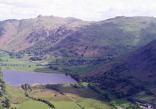
Martindale is a valley, village and civil parish in Cumbria, England, situated within the Lake District National Park between the lakes of Ullswater and Haweswater. The valley is served by a narrow minor road which runs as far as the farm of Dale Head. This road commences at Howtown, a hamlet on the shore of Ullswater that forms part of the civil parish but is not in the valley of Martindale, and passes over a mountain pass or hause into the valley.

References

  1. Defra, UK - Error page
  2. Wainwright, A: A Pictorial Guide to the Lakeland Fells, Book 2: ISBN   0-7112-2455-2