Fairfield is a fell in the English Lake District. It is the highest of a group of hills in the Eastern Fells, standing to the south of the Helvellyn range.

High Street is a fell in the English Lake District. At 828 metres (2,717 ft), its summit is the highest point in the far eastern part of the national park. The fell is named after the Roman road that ran over the summit.

Dale Head is a fell in the north-western sector of the Lake District, in northern England. It is 753 metres or 2,470 foot above sea level and stands immediately north of Honister Pass, the road between Borrowdale and Buttermere.

Place Fell is a hill in the English Lake District. It stands at the corner of the upper and middle reaches of Ullswater, with steep western flanks overlooking the villages of Glenridding and Patterdale.

Little Mell Fell is a small fell in the English Lake District. It is an outlier of the Eastern Fells, standing to the north of Ullswater near the village of Watermillock, and connected to other high ground by a narrow col to the south.

St Sunday Crag is a fell in the English Lake District, part of the Fairfield group in the Eastern Fells. It is a prominent feature in the Patterdale skyline, with a distinctive rounded shape. Indeed, it figures so finely in views from the upper reach of the lake that it is sometimes referred to as ‘the Ullswater Fell’.

Rest Dodd is a fell in the English Lake District. It is situated in the quieter far eastern region of the national park and reaches a height of 696 metres (2,283 ft). Rest Dodd is a fell that is often by-passed by walkers as they travel the busy footpath between Ullswater and Haweswater either to climb the more significant fell of High Street or strive to complete Alfred Wainwright’s Coast to Coast Walk. Indeed Wainwright describes Rest Dodd as “A fell of little interest although the east flank falls spectacularly in fans of colourful scree”. The fell is usually climbed in conjunction with other nearby "Wainwright" fells such as The Nab, Brock Crags and Angletarn Pikes.

Angletarn Pikes is a fell in the English Lake District near the village of Patterdale. Its most notable feature is Angle Tarn from which it derives its name.

Helm Crag is a fell in the English Lake District situated in the Central Fells to the north of Grasmere. Despite its low height it sits prominently at the end of a ridge, easily seen from the village. This, combined with the distinctive summit rocks which provide the alternative name 'The Lion and the Lamb', makes it one of the most recognised hills in the District.
Steel Knotts is a fell in the English Lake District, near to Ullswater in the Far Eastern Fells. It stands between the valleys of Fusedale and Martindale on a ridge running north–south.

Rampsgill Head is a fell in the English Lake District, standing to the west of Haweswater Reservoir in the Far Eastern Fells. It forms the focal point of three ridges which fan out north-east, north-west and south.

Beda Fell is a fell in the English Lake District, situated to the south of Ullswater. It divides the valleys of Boredale and Bannerdale within the Martindale system.

Hart Crag is a fell in the English Lake District, being one of the Fairfield group of hills in the Eastern Fells.

Birkhouse Moor is a fell in the English Lake District, an outlier of the Helvellyn range in the Eastern Fells. It is properly an eastern ridge of Helvellyn, but was treated as a separate fell by Alfred Wainwright in his Pictorial Guide to the Lakeland Fells. That convention is followed here.

Boredale sometimes known as Boardale, is a valley within Lake District National Park, in Cumbria, England. The valley is close to the eastern shore of Ullswater and lies between the hills of Place Fell to the west and Beda Fell to the east.

The Eastern Fells are a part of the Cumbrian Mountains in the Lake District of England. Centred on Helvellyn they primarily comprise a north–south ridge running between Ullswater and Lakeland's Central Valley.
The Far Eastern Fells are a part of the Cumbrian Mountains in the Lake District of England. Reaching their highest point at High Street, they occupy a broad area to the east of Ullswater and Kirkstone Pass. Much quieter than the central areas of Lakeland they offer in general easier walking as the fells merge mainly into the surrounding moorlands.

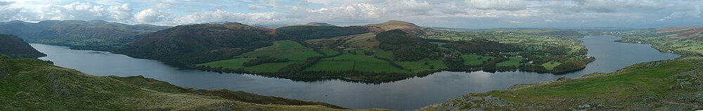
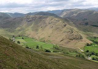
Martindale is a valley, village and civil parish in Cumbria, England, situated within the Lake District National Park between the lakes of Ullswater and Haweswater. The valley is served by a narrow minor road which runs as far as the farm of Dale Head. This road commences at Howtown, a hamlet on the shore of Ullswater that forms part of the civil parish but is not in the valley of Martindale, and passes over a mountain pass or hause into the valley.

St Peter’s Church is situated in the valley of Martindale in Cumbria, England. The church is located at the top of the hause on the minor road between Martindale and Howtown. It is within the parish of Martindale and is often referred to as the “New Church” to avoid confusion with St Martin’s Church, the “Old Church” and former place of worship of Martindale, which lies half a mile further up the valley. The church is a Grade II listed building.

The Ullswater Way is a 20-mile (32 km) waymarked walking route around Ullswater in the English Lake District. It was created by a partnership which included The Lake District National Park Authority, the National Trust, Eden District Council, and Ullswater 'Steamers' and was opened on 25 April 2016 by broadcaster and film-maker Eric Robson. The idea of a path circumnavigating the lake had been considered for many years, but the 2015 Cumbria floods which devastated the area gave an incentive for the completion of the project.