
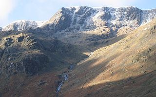
Fairfield is a fell in the English Lake District. It is the highest of a group of hills in the Eastern Fells, standing to the south of the Helvellyn range.

Place Fell is a hill in the English Lake District. It stands at the corner of the upper and middle reaches of Ullswater, with steep western flanks overlooking the villages of Glenridding and Patterdale.

Hallin Fell is a hill in the English Lake District surrounded on three sides by Ullswater.
Nethermost Pike is a fell in Cumbria, England, and a part of the Lake District. At 891 metres (2,923 ft) it is the second highest Wainwright in the Helvellyn range, the highest of which is Helvellyn itself. It is located close to the southern end of the ridge, with Helvellyn to the north, and High Crag and Dollywaggon Pike to the south. Nethermost Pike, along with many of the Eastern Fells, lies between Thirlmere in the west and the Ullswater catchment in the east. The closest villages are Glenridding and Patterdale on the shores of Ullswater, over 8 kilometres (5 mi) away.

Buckbarrow is a small fell in the English Lake District overlooking the western end of Wastwater. It is featured in Alfred Wainwright’s Pictorial Guide to the Lakeland Fells and is given a height of 1,410 ft approximately; however, the Ordnance Survey and other guidebooks now give an altitude of 423 m (1,388 ft). The fell’s name means ‘The hill of the buck or goat’. It is derived either from the Old English word bucc meaning buck or the Old Norse word bokki meaning a male goat.

Stybarrow Dodd is a mountain or fell in the English Lake District. It stands immediately north of Sticks Pass on the main ridge of the Helvellyn range in the Eastern Fells, which is situated between the lakes of Thirlmere and the Ullswater.
Crag Hill is a mountain in the North Western part of the English Lake District. It was formerly known as Eel Crag; however, the Ordnance Survey now marks Eel Crag as referring to the northern crags of the fell. It is not to be confused with another Crag Hill lying on the border of North Yorkshire.

Rest Dodd is a fell in the English Lake District. It is situated in the quieter far eastern region of the national park and reaches a height of 696 metres (2,283 feet). Rest Dodd is a fell that is often by-passed by walkers as they travel the busy footpath between Ullswater and Haweswater either to climb the more significant fell of High Street or strive to complete Alfred Wainwright’s Coast to Coast Walk. Indeed Wainwright describes Rest Dodd as “A fell of little interest although the east flank falls spectacularly in fans of colourful scree”. The fell is usually climbed in conjunction with other nearby "Wainwright" fells such as The Nab, Brock Crags and Angletarn Pikes.

Angletarn Pikes is a fell in the English Lake District near the village of Patterdale. Its most notable feature is Angle Tarn from which it derives its name.

Red Pike is a fell in the High Stile range in the western English Lake District, which separates Ennerdale from the valley of Buttermere and Crummock Water. It is 2,476 ft (755 m) high. The direct ascent of Red Pike from Buttermere is very popular and the ridge walk from Red Pike to Haystacks is regarded as one of the finest in the area, with excellent views of the Scafells, Great Gable and Pillar.

Ullscarf is a fell in the English Lake District close to the geographical centre of the Cumbrian hills. It forms part of the watershed between the Derwentwater and Thirlmere catchments, a ridge running broadly north-south.

Arthur's Pike is a fell in the English Lake District, near Ullswater. It is a subsidiary top on the ridge falling north from Loadpot Hill in the Far Eastern Fells. An extensive craggy face stands above the lower reach of Ullswater.
Loadpot Hill is a fell in the English Lake District, between Haweswater and Ullswater.
Brock Crags is a fell in the English Lake District, standing above Hartsop in the Far Eastern Fells. It forms part of the perimeter of Martindale, lying on the long ridge from Rampsgill Head to Place Fell.

Beda Fell is a fell in the English Lake District, situated to the south of Ullswater. It divides the valleys of Boredale and Bannerdale within the Martindale system.

Thornthwaite Crag is a fell in the English Lake District, standing to the west of Haweswater Reservoir. It is a focal point of the Far Eastern Fells, standing at the head of several valleys.
Hart Side is a subsidiary top on one of the east ridges of Stybarrow Dodd, which is a mountain in the English Lake District, west of Ullswater on the main Helvellyn ridge in the Eastern Fells. With a height of 2,480 feet (756 m) Hart Side rises above the col separating it from Green Side by 75 feet (23 m).

Sheffield Pike is a fell in the English Lake District, a prominent intermediate top on one of the eastern ridges of Stybarrow Dodd. It separates and stands high above the Glencoyne and Glenridding valleys, on the eastern side of the Helvellyn range in the Eastern Fells and it looks down onto Ullswater.
Glenridding Dodd is a small fell in the English Lake District, at the end of a ridge descending from the Helvellyn range in the Eastern Fells. It stands above the village of Glenridding and on the western shore of Ullswater. Although small and not of great elevation, its top is a fine viewpoint for Ullswater and for the fells clustered round the valleys above Patterdale.

The Far Eastern Fells are a group of hills in the English Lake District. Reaching their highest point at High Street, they occupy a broad area to the east of Ullswater and Kirkstone Pass. Much quieter than the central areas of Lakeland they offer in general easier walking as the fells merge mainly into the surrounding moorlands.


