Grey Crag

Last updated

Grey Crag
Grey Crag.jpg
Grey Crag from Greycrag Tarn to the north-west
Highest point
Elevation 638 m (2,093 ft)
Prominence c. 45 m (150 ft)
Parent peak Tarn Crag
Listing Wainwright, Nuttall, Hewitt
Coordinates 54°27′28″N2°46′39″W / 54.45768°N 2.77739°W / 54.45768; -2.77739
Geography
Lake District National Park UK relief location map.png
Red triangle with thick white border.svg
Grey Crag
Location in Lake District, UK
Location Cumbria, England
Parent range Lake District, Far Eastern Fells
OS grid NY497072
Topo map OS Explorer OL7
Listed summits of Grey Crag
NameGrid refHeightStatus
Harrop Pike NY500078 637 mNuttall

Grey Crag is a fell in the English Lake District. It stands to the east of Longsleddale in the Far Eastern Fells.

Contents

Topography

North of Sadgill, the valley of Longsleddale narrows considerably with walls of crag on either side. Grey Crag is the first fell encountered above the eastern side, although the top is not visible from below. What is in sight is a short flat-topped spur at a height of around 1,600 ft (490 m) which juts out southwards from the body of the fell. This is Great Howe, and its steep flanks provide the east wall of Longsleddale, together with further outcrops above the side valley of Stockdale. Grey Crag proper is a second tier of crags, set back from Great Howe and just below the summit, thus giving its name to the entire fell.

Grey Crag is the focus of an extensive ridge system stretching out eastwards to the distant Lune and Eden Valleys. Grey Crag lies on the main watershed of the Cumbrian hills, its runoff reaching the sea at both the Solway Firth and Morecambe Bay. The long east ridges have a moorland character and provide easy walking in quiet conditions. The principal tops are Ancrow Brow, 1,820 feet (550 m), White Howe, 1,738 feet (530 m), Lords Seat, 1,719 feet (524 m), and Great Yarlside, 1,950 feet (590 m). These ridges encompass the valleys of Bannisdale, Crookdale, Wet Sleddale, Borrowdale and Wasdale, the latter two of which should not be confused with their more famous Lakeland namesakes.

To the north of the summit is a marshy depression, containing Greycrag Tarn. This is a series of small pools in the bed of a larger historic water body. Beyond the tarn is Grey Crag's sister fell, Tarn Crag.

Summit

The top of the fell is a short ridge with the summit at the south west end. Half a mile (800 m) to the north east is a second top, Harrop Pike, only marginally lower at 2,089 ft (637 m). A fence joins the summit ridge about halfway along from the direction of Tarn Crag, and then makes for Harrop Pike. The true top has a small cairn, while Harrop Pike sports a more impressive columnar beacon. The views east and south are expansive while westwards the Coniston and Scafell groups can be seen. [1]

Ascents

Grey Crag can be climbed from Longsleddale via Great Howe, or from the vicinity of the A6 (Shap) road via any of the long eastern ridges mentioned above.

Haweswater aqueduct

Great Howe carries the remains of a surveying pillar on its eastern flank. This unusual stone and concrete construction is cleft at the top to provide a sight line and was originally surrounded by a wooden frame, now decayed. This is one of four such pillars built during the construction of the Haweswater aqueduct. Below Branstree, Tarn Crag and Great Howe is the first section of the pipeline carrying water from the reservoir toward Manchester. The tunnel, some 1,000 ft below Great Howe, required 250 tons of gelignite for blasting, and when constructed in the 1930s was the longest such pipeline in Britain. It emerges into Longsleddale below the southern end of Great Howe, where the spoil can still be seen. [2]

Related Research Articles

<span class="mw-page-title-main">Fairfield (Lake District)</span> Fell in the English Lake District

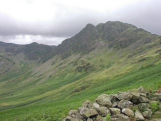
Fairfield is a fell in the English Lake District. It is the highest of a group of hills in the Eastern Fells, standing to the south of the Helvellyn range.

<span class="mw-page-title-main">Longsleddale</span> Valley and civil parish in Cumbria, England

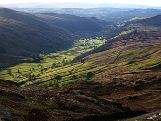
Longsleddale is a valley and civil parish in the South Lakeland district of Cumbria, England. It includes the hamlet of Sadgill. The parish has a population of 73. As the population taken at the 2011 Census was less than 100, details are maintained in the civil parish of Whitwell and Selside.

<span class="mw-page-title-main">Place Fell</span> Fell in the Lake District, Cumbria, England

Place Fell is a hill in the English Lake District. It stands at the corner of the upper and middle reaches of Ullswater, with steep western flanks overlooking the villages of Glenridding and Patterdale.

<span class="mw-page-title-main">Haystacks (Lake District)</span> Fell in the Lake District, Cumbria, England

Haystacks, or Hay Stacks, is a hill in England's Lake District, situated at the south-eastern end of the Buttermere Valley. Although not of any great elevation, Haystacks has become one of the most popular fells in the area. This fame is partly due to the writings of Alfred Wainwright, who espoused its attractions and chose it as the place where he wanted his ashes scattered. Its large, undulating summit contains many rock formations, tarns and hidden recesses.

<span class="mw-page-title-main">High Stile</span> Fell in the Lake District, Cumbria, England

High Stile is a mountain in the western part of the Lake District in North West England. It is the eleventh-highest English Marilyn, standing 807 metres (2,648 ft) high, and has a relative height of 362 metres (1,188 ft).

<span class="mw-page-title-main">Kirk Fell</span> Fell in the Lake District, England

Kirk Fell is a fell in the Western part of the English Lake District. It is situated between Great Gable and Pillar on the long ring of fells surrounding the valley of Ennerdale, and also stands over Wasdale to the south. However, it is separated from its two higher neighbours by the low passes of Black Sail and Beck Head, giving it a high relative height and making it a Marilyn, the thirteenth highest in the Lake District.

<span class="mw-page-title-main">Harter Fell (Mardale)</span> Mountain in United Kingdom

Harter Fell is a fell in the far eastern part of the English Lake District. The summit at lies the meeting point of three ridges, and Harter Fell forms the head of three valleys: Mardale, Longsleddale and the valley of the River Kent.

<span class="mw-page-title-main">Branstree</span> Fell in the Lake District, Cumbria, England

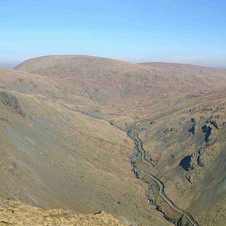
Branstree is a fell in the Far Eastern part of the English Lake District. It overlooks the valley of Mardale and Haweswater Reservoir.

<span class="mw-page-title-main">Dow Crag</span> Fell in the Lake District, Cumbria, England

Dow Crag is a fell in the English Lake District near Coniston, Cumbria. The eastern face is one of the many rock faces in the Lake District used for rock climbing.

<span class="mw-page-title-main">Shipman Knotts</span>

Shipman Knotts is a fell in the English Lake District in Cumbria, England. It reaches a height of 587 metres (1,926 ft) and is situated in one of the quieter areas of the national park, 2 kilometres (1.2 mi) north-east of Kentmere village. Although not one of the best-known Lake District fells, it earned a separate chapter in Alfred Wainwright’s Pictorial Guide to the Lakeland Fells due to “Its characteristic roughness. .. rocky outcrops are everywhere on its steep slopes”.

<span class="mw-page-title-main">Red Pike (Buttermere)</span> Mountain in the English Lake District, Cumbria, England

Red Pike is a fell in the High Stile range in the western English Lake District, which separates Ennerdale from the valley of Buttermere and Crummock Water. It is 2,476 ft (755 m) high. The direct ascent of Red Pike from Buttermere is very popular and the ridge walk from Red Pike to Haystacks is regarded as one of the finest in the area, with excellent views of the Scafells, Great Gable and Pillar.

<span class="mw-page-title-main">Red Pike (Wasdale)</span> Mountain in the English Lake District, Cumbria, England

Red Pike is a fell in the English Lake District. It is 826 m or 2,709 ft high and lies due north of Wast Water. It is often climbed as part of the Mosedale Horseshoe, a walk which also includes Pillar.

<span class="mw-page-title-main">Scoat Fell</span> Mountain in the English Lake District, Cumbria, England

Scoat Fell is a fell in the western part of the English Lake District. It stands at the head of the Mosedale Horseshoe with its back to Ennerdale. Paths lead to Scoat Fell from Ennerdale over Steeple, from Wasdale over Red Pike, and along the ridge from Pillar.

<span class="mw-page-title-main">Ullscarf</span> Fell in England

Ullscarf is a fell in the English Lake District close to the geographical centre of the Cumbrian hills. It forms part of the watershed between the Derwentwater and Thirlmere catchments, a ridge running broadly north-south.

<span class="mw-page-title-main">Beda Fell</span> Fell in the Lake District, Cumbria, England

Beda Fell is a fell in the English Lake District, situated to the south of Ullswater. It divides the valleys of Boredale and Bannerdale within the Martindale system.

<span class="mw-page-title-main">Tarn Crag (Far Eastern Fells)</span> Fell in the Lake District, Cumbria, England

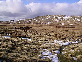
Tarn Crag is a fell in the English Lake District. It stands to the east of Longsleddale in the Far Eastern Fells.

<span class="mw-page-title-main">Lingmoor Fell</span> Fell in the Lake District, Cumbria, England

Lingmoor Fell is a fell in the English Lake District, situated eight kilometres west of Ambleside. The fell reaches a height of 469 m (1,540 ft) and divides the valleys of Great Langdale and Little Langdale. The fell's name originates from the Old Norse word lyng meaning “heather covered”. The actual summit of the fell is named as Brown How on Ordnance Survey maps.

<span class="mw-page-title-main">Rossett Pike</span>

Rossett Pike is a fell in the English Lake District. It is located at the head of Mickleden, one of two tributary valleys of Great Langdale.

<span class="mw-page-title-main">Great Carrs</span> Fell in the Lake District, Cumbria, England

Great Carrs is a fell in the English Lake District. It stands above Wrynose Pass in the southern part of the District.

<span class="mw-page-title-main">Far Eastern Fells</span> Mountain range in Cumbria, England

The Far Eastern Fells are a group of hills in the English Lake District. Reaching their highest point at High Street, they occupy a broad area to the east of Ullswater and Kirkstone Pass. Much quieter than the central areas of Lakeland they offer in general easier walking as the fells merge mainly into the surrounding moorlands.

References

  1. Alfred Wainwright: A Pictorial Guide to the Lakeland Fells , Book 2: ISBN   0-7112-2455-2
  2. Berry, G:Mardale Revisited:Westmoreland Gazette (1996) ISBN   1-901081-00-1