Mardale Ill Bell

Last updated

Mardale Ill Bell
Mardale Ill Bell from Kentmere.jpg
Mardale Ill Bell (left) from Kentmere. Nan Bield Pass crosses the lowest point in the background ridge.
Highest point
Elevation 760 m (2,490 ft)
Prominence c. 14 m
Parent peak High Street
Listing Wainwright,
Coordinates 54°29′03″N2°51′13″W / 54.48413°N 2.85352°W / 54.48413; -2.85352
Geography
Lake District National Park UK relief location map.png
Red triangle with thick white border.svg
Mardale Ill Bell
Location in Lake District, UK
Location Cumbria, England
Parent range Lake District, Far Eastern Fells
OS grid NY448102
Topo map OS Explorer OL5, Explorer OL7

Mardale Ill Bell is a fell in the English Lake District, rising to the south west of Haweswater Reservoir. It stands on the watershed between Mardale and Kentmere and is the highpoint of the south-eastern ridge of High Street, midway on its course to Harter Fell.

Contents

Topography

The head of the Kentmere valley lies to the south-west of the fell with rough slopes leading down over scree to Kentmere Reservoir. Mardale Ill Bell sends out a short grass-topped spur, Lingmell End, which splits the head of the valley into two.

The north-eastern face of Mardale Ill Bell forms the craggy backdrop to Blea Water. This perfect corrie tarn is the deepest in the Lake District at 207 feet (63 m). [1] [note 1] Its outflow feeds Haweswater, joining with that of a second tarn, Small Water. Between the two, Mardale Ill Bell throws out the rocky spur of Piot Crag. Two tiers of crag drop down to the confluence at Mardale Waters.

South-east of the summit a rough narrowing ridge drops to Nan Bield Pass at 2,100 feet (640 m), before rising again over rocky steps to Harter Fell. Nan Bield was the ancient trading route between Kentmere and the now drowned village of Mardale Green, submerged by the raising of Haweswater in the 1940s. Near the shore of Small Water on the descending path are a number of stone shelters, pointers to the earlier importance of the pass. These each provide refuge for one person in extremis, entrance being via crawling.

North-west from Mardale Ill Bell the grassy ridge crosses a wet depression and then expands into a wide plateau, triangular in plan. High Street and Thornthwaite Crag are at the other two corners, with the Roman road crossing north to south.

Summit

The summit has two large cairns on grass, the northern one being the top. The view westwards is confined by higher fells but the Ill Bell ridge and Coniston range are seen to good effect. [2] Blea Water and Small Water can be brought into sight from the rim of the crags.

Ascents

The most popular routes of ascent are on the Mardale side. From the road end Nan Bield pass can be used, or the impressive scenery of Piot Crag can be attained from the shore of either Blea or Small Water. From Kentmere, Nan Bield provides the obvious route, although a pathless climb up to the top of Lingmell End is possible.

Notes

  1. Blea water is the deepest tarn but its depth is exceeded by some large lakes such as Wastwater and Windermere.

Related Research Articles

<span class="mw-page-title-main">Longsleddale</span> Valley and civil parish in Cumbria, England

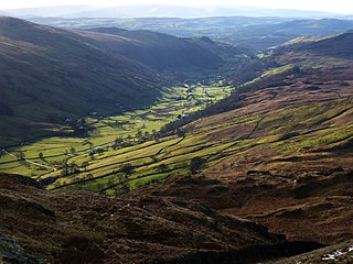
Longsleddale is a valley and civil parish in the South Lakeland district of Cumbria, England. It includes the hamlet of Sadgill. The parish has a population of 73. As the population taken at the 2011 Census was less than 100, details are maintained in the civil parish of Whitwell and Selside.

<span class="mw-page-title-main">High Street (Lake District)</span> Mountain in Cumbria, England

High Street is a fell in the English Lake District. At 828 metres (2,717 ft), its summit is the highest point in the far eastern part of the national park. The fell is named after the Roman road that ran over the summit.

<span class="mw-page-title-main">Harter Fell (Mardale)</span> Mountain in United Kingdom

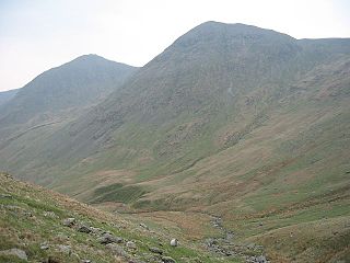
Harter Fell is a fell in the far eastern part of the English Lake District. The summit at lies the meeting point of three ridges, and Harter Fell forms the head of three valleys: Mardale, Longsleddale and the valley of the River Kent.

<span class="mw-page-title-main">Branstree</span> Fell in the Lake District, Cumbria, England

Branstree is a fell in the Far Eastern part of the English Lake District. It overlooks the valley of Mardale and Haweswater Reservoir.

<span class="mw-page-title-main">Yoke (Lake District)</span> Fell in the Lake District, Cumbria, England

Yoke is a fell in the Lake District in Cumbria, England. It has a height of 706 metres (2,316 ft) and is situated in the far eastern sector of the national park, 6+12 kilometres ENE of the town of Ambleside. Yoke is the southern extremity of the long ridge that runs southwards from the fell of High Street. Yoke’s name is believed to be derived from the Old English language word geoc which is similar to the German word joch meaning mountain ridge.

<span class="mw-page-title-main">Shipman Knotts</span>

Shipman Knotts is a fell in the English Lake District in Cumbria, England. It reaches a height of 587 metres (1,926 ft) and is situated in one of the quieter areas of the national park, 2 kilometres north-east of Kentmere village. Although not one of the best-known Lake District fells, it earned a separate chapter in Alfred Wainwright’s Pictorial Guide to the Lakeland Fells due to “Its characteristic roughness. .. rocky outcrops are everywhere on its steep slopes”.

<span class="mw-page-title-main">Ullscarf</span> Fell in England

Ullscarf is a fell in the English Lake District close to the geographical centre of the Cumbrian hills. It forms part of the watershed between the Derwentwater and Thirlmere catchments, a ridge running broadly north-south.

<span class="mw-page-title-main">Tarn Crag (Easedale)</span> Fell in the Lake District, Cumbria, England

Tarn Crag is a fell in the Central Fells of the English Lake District. Strictly the name refers only to the rock face looking down upon Easedale Tarn, but Alfred Wainwright applied it to the entire ridge lying between the Easedale and Far Easedale valleys in his Pictorial Guide to the Lakeland Fells

<span class="mw-page-title-main">High Raise (High Street)</span> Mountain in the English Lake District, Cumbria, England

High Raise is a fell in the English Lake District, standing to the west of Haweswater Reservoir in the Far Eastern Fells. Note that another High Raise is the highpoint of the Central Fells.

<span class="mw-page-title-main">Kidsty Pike</span>

Kidsty Pike is a fell in the English Lake District, standing to the west of Haweswater Reservoir. It is a subsidiary top of Rampsgill Head, but has long achieved the status of a separate fell, thanks to its classic peaked profile. Wainwright followed this convention in his Pictorial Guide to the Lakeland Fells.

<span class="mw-page-title-main">Thornthwaite Crag</span> Mountain in United Kingdom

Thornthwaite Crag is a fell in the English Lake District, standing to the west of Haweswater Reservoir. It is a focal point of the Far Eastern Fells, standing at the head of several valleys.

<span class="mw-page-title-main">Froswick</span> Fell in the Lake District, Cumbria, England

Froswick is a fell in the English Lake District, standing on the fine narrow ridge between the valleys of Kentmere and Troutbeck.

<span class="mw-page-title-main">Ill Bell</span> Fell in the Lake District, Cumbria, England

Ill Bell is a fell in the English Lake District, in the county of Cumbria, standing on the narrow ridge between the valleys of Kentmere and Troutbeck.

<span class="mw-page-title-main">Kentmere Pike</span>

Kentmere Pike is a fell in the English Lake District, rising between the valleys of Kentmere and Longsleddale. It is the highpoint on the ridge between Harter Fell and Shipman Knotts.

<span class="mw-page-title-main">Sallows</span> Fell in the Lake District, Cumbria, England

Sallows is a fell in the English Lake District, rising between the valleys of Kentmere and Troutbeck. It is the highest point in the upland area to the south of Garburn Pass, variously termed Kentmere Park and Applethwaite Common on Ordnance Survey maps.

Selside Pike or Selside is a fell in the English Lake District. It stands between the valleys of Mardale and Swindale in the Far Eastern Fells.

<span class="mw-page-title-main">Tarn Crag (Far Eastern Fells)</span> Fell in the Lake District, Cumbria, England

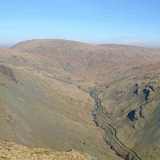
Tarn Crag is a fell in the English Lake District. It stands to the east of Longsleddale in the Far Eastern Fells.

<span class="mw-page-title-main">Grey Crag</span> Fell in the Lake District, Cumbria, England

Grey Crag is a fell in the English Lake District. It stands to the east of Longsleddale in the Far Eastern Fells.

<span class="mw-page-title-main">Far Eastern Fells</span> Mountain range in Cumbria, England

The Far Eastern Fells are a part of the Cumbrian Mountains in the Lake District of England. Reaching their highest point at High Street, they occupy a broad area to the east of Ullswater and Kirkstone Pass. Much quieter than the central areas of Lakeland they offer in general easier walking as the fells merge mainly into the surrounding moorlands.

References

  1. Blair, D: Exploring Lakeland Tarns: Lakeland Manor Press (1993) ISBN   0-9543904-1-5
  2. Alfred Wainwright: A Pictorial Guide to the Lakeland Fells , Book 2: ISBN   0-7112-2455-2