
Bowfell is a pyramid-shaped mountain lying at the heart of the English Lake District, in the Southern Fells area. It is the sixth-highest mountain in the Lake District and one of the most popular of the Lake District fells for walkers. It is listed in Alfred Wainwright's 'best half dozen' Lake District fells.

Fairfield is a fell in the English Lake District. It is the highest of a group of hills in the Eastern Fells, standing to the south of the Helvellyn range.

Place Fell is a hill in the English Lake District. It stands at the corner of the upper and middle reaches of Ullswater, with steep western flanks overlooking the villages of Glenridding and Patterdale.

Esk Pike is a fell in the English Lake District, one of the cirque of hills forming the head of Eskdale.
The Nab is a fell in the English Lake District. It has a moderate height of 576 metres (1,888 feet), and lies in the quieter eastern high ground between Ullswater and Haweswater Reservoir. The Nab is included in Alfred Wainwright's list of Lakeland fells and many walkers feel compelled to climb it to complete their list of 'Wainwrights' even though it is not a significant fell and is awkward to reach.

St Sunday Crag is a fell in the English Lake District, part of the Fairfield group in the Eastern Fells. It is a prominent feature in the Patterdale skyline, with a distinctive rounded shape. Indeed, it figures so finely in views from the upper reach of the lake that it is sometimes referred to as ‘the Ullswater Fell’.

Dollywaggon Pike is a fell in the English Lake District. It stands on the main spine of the Helvellyn range in the Eastern Fells, between Thirlmere and the Ullswater catchment.

Pike of Blisco, or Pike o' Blisco, is a mountain in the Lake District in Cumbria, England. Located between the valleys of Great Langdale and Little Langdale, its relative isolation from neighbouring fells together with slopes falling away immediately from the summit in all directions mean it has excellent views: the view of the Langdale Pikes across Great Langdale is particularly arresting.

Rest Dodd is a fell in the English Lake District. It is situated in the quieter far eastern region of the national park and reaches a height of 696 metres (2,283 feet). Rest Dodd is a fell that is often by-passed by walkers as they travel the busy footpath between Ullswater and Haweswater either to climb the more significant fell of High Street or strive to complete Alfred Wainwright’s Coast to Coast Walk. Indeed Wainwright describes Rest Dodd as “A fell of little interest although the east flank falls spectacularly in fans of colourful scree”. The fell is usually climbed in conjunction with other nearby "Wainwright" fells such as The Nab, Brock Crags and Angletarn Pikes.

Dow Crag is a fell in the English Lake District near Coniston, Cumbria. The eastern face is one of the many rock faces in the Lake District used for rock climbing.

Gray Crag is a fell in the Lake District in Cumbria, England.
Blea Rigg is a fell in the English Lake District, lying between the valleys of Easedale and Great Langdale. One of the Central Fells, it is a broad plateau with a succession of rocky tops. Many routes of ascent are possible, beginning either from Grasmere or Great Langdale, though the paths are often poorly marked and hard to follow.

Little Hart Crag is a fell in the Lake District area of England. It stands at the head of Scandale, six kilometres north of Ambleside, at a height of 637 metres (2090 feet). It is an eastern outlier of Dove Crag in the Eastern Fells, although it does have 34 metres of prominence from that fell making it both a Hewitt and a Nuttall fell. It is frequently climbed as part of the Dovedale horseshoe, an 11 kilometre walk over the neighbouring fells of Hartsop above How, Hart Crag, Dove Crag and High Hartsop Dodd, starting and finishing at Brothers Water.

High Raise is a fell in the English Lake District, standing to the west of Haweswater Reservoir in the Far Eastern Fells. Note that another High Raise is the highpoint of the Central Fells.

Rampsgill Head is a fell in the English Lake District, standing to the west of Haweswater Reservoir in the Far Eastern Fells. It forms the focal point of three ridges which fan out north-east, north-west and south.
Brock Crags is a fell in the English Lake District, standing above Hartsop in the Far Eastern Fells. It forms part of the perimeter of Martindale, lying on the long ridge from Rampsgill Head to Place Fell.

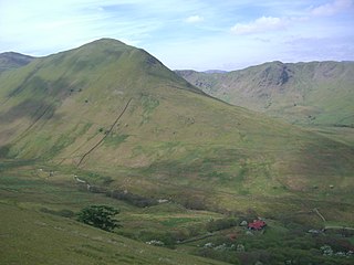
Beda Fell is a fell in the English Lake District, situated to the south of Ullswater. It divides the valleys of Boredale and Bannerdale within the Martindale system.

Rossett Pike is a fell in the English Lake District. It is located at the head of Mickleden, one of two tributary valleys of Great Langdale.

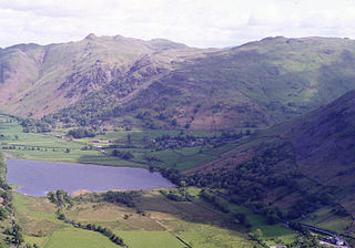
Boredale sometimes known as Boardale, is a valley within Lake District National Park, in Cumbria, England. The valley is close to the eastern shore of Ullswater and lies between the hills of Place Fell to the west and Beda Fell to the east.

The Far Eastern Fells are a group of hills in the English Lake District. Reaching their highest point at High Street, they occupy a broad area to the east of Ullswater and Kirkstone Pass. Much quieter than the central areas of Lakeland they offer in general easier walking as the fells merge mainly into the surrounding moorlands.


