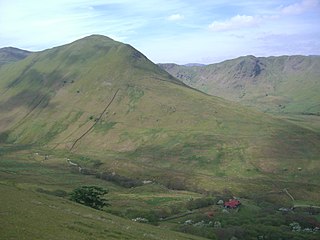
Great End is the most northerly mountain in the Scafell chain, in the English Lake District. From the south it is simply a lump continuing this chain. From the north, however, it appears as an immense mountain, with an imposing north face rising above Sprinkling Tarn (lake). This is a popular location for wild camping, and the north face attracts many climbers.

Place Fell is a hill in the English Lake District. It stands at the corner of the upper and middle reaches of Ullswater, with steep western flanks overlooking the villages of Glenridding and Patterdale.

Little Mell Fell is a small fell in the English Lake District. It is an outlier of the Eastern Fells, standing to the north of Ullswater near the village of Watermillock, and connected to other high ground by a narrow col to the south.
Hallin Fell is a hill in the English Lake District surrounded on three sides by Ullswater.

The Nab is a fell in the English Lake District. It has a moderate height of 576 metres (1,888 feet), and lies in the quieter eastern high ground between Ullswater and Haweswater Reservoir. The Nab is included in Alfred Wainwright's list of Lakeland fells and many walkers feel compelled to climb it to complete their list of 'Wainwrights' even though it is not a significant fell and is awkward to reach.

Rest Dodd is a fell in the English Lake District. It is situated in the quieter far eastern region of the national park and reaches a height of 696 metres (2,283 feet). Rest Dodd is a fell that is often by-passed by walkers as they travel the busy footpath between Ullswater and Haweswater either to climb the more significant fell of High Street or strive to complete Alfred Wainwright’s Coast to Coast Walk. Indeed Wainwright describes Rest Dodd as “A fell of little interest although the east flank falls spectacularly in fans of colourful scree”. The fell is usually climbed in conjunction with other nearby "Wainwright" fells such as The Nab, Brock Crags and Angletarn Pikes.

Angletarn Pikes is a fell in the English Lake District near the village of Patterdale. Its most notable feature is Angle Tarn from which it derives its name.

Ard Crags is a fell in the Lake District in Cumbria, England, it is situated in the Newlands Valley just off the minor road between Keswick and Buttermere. The Ordnance Survey officially records the fell's altitude at 581 metres (1,906 feet), considerably more than the approximate 1,860 feet that Alfred Wainwright attributed to it in his Pictorial Guide to the North Western Fells, published in 1964 well before the advent of satellite mapping. Ard Crags is situated close to other higher fells such as Causey Pike and Eel Crag and can be easily overlooked. However, viewed from certain points in the Rigg Beck or Newlands valley area it presents a clearly defined and pyramidal shape which catches the eye.

Shipman Knotts is a fell in the English Lake District in Cumbria, England. It reaches a height of 587 metres (1,926 ft) and is situated in one of the quieter areas of the national park, 2 kilometres (1.2 mi) north-east of Kentmere village. Although not one of the best-known Lake District fells and strictly speaking it is just the southern shoulder of Kentmere Pike it earned a separate chapter in Alfred Wainwright’s Pictorial Guide to the Lakeland Fells due to “Its characteristic roughness…rocky outcrops are everywhere on its steep slopes”.

Glaramara is a fell in the English Lake District in Cumbria. It is a substantial fell that is part of a long ridge that stretches for over six kilometres from Stonethwaite in Borrowdale up to the important mountain pass of Esk Hause. The summit of Glaramara at 783 m (2,569 ft) is the central point of this ridge, which separates the valleys of Langstrath and Grains Gill. However, the ridge has two additional fells, numerous subsidiary tops and several small tarns making its traverse an appealing and challenging walk.

Hopegill Head is a fell in the English Lake District in Cumbria. It is located nine kilometres west of the town of Keswick and is well seen from the B5292 road which crosses the Whinlatter Pass.

Dove Crag is a fell in the English Lake District. Situated in the Eastern Fells of the national park, seven kilometres south-south-west of Glenridding, it reaches a height of 792 metres. The fell is often climbed as part of the Fairfield horseshoe walk but a direct ascent from Patterdale is required to show the fell's full potential, displaying the impressive crags just to the north east of the summit. The highest point was originally unnamed on maps, being just a minor top, but over the years the summit has adopted the name of Dove Crag by mutual accord..

Seat Sandal is a fell in the English Lake District, situated four kilometres north of the village of Grasmere from where it is very well seen. Nevertheless, it tends to be overshadowed by its more illustrious neighbours in the Eastern Fells, Helvellyn and Fairfield.

Wether Hill is a fell in the English Lake District, between Martindale and Haweswater. It lies on the main north-south ridge of the Far Eastern Fells between Loadpot Hill and High Raise. Lesser ridges also radiate out to the east and north-west.

Beda Fell is a fell in the English Lake District, situated to the south of Ullswater. It divides the valleys of Boredale and Bannerdale within the Martindale system.

Broom Fell is a small hill in the English Lake District. It lies on a ridge connecting Lord's Seat and Graystones, but is rarely climbed. Alfred Wainwright did however accord it the status of a separate fell in his influential guidebook series, the Pictorial Guide to the Lakeland Fells.

Knott Rigg is a fell at the head of the Newlands Valley in the English Lake District. It is situated some 8.5 kilometres south west of Keswick and has a modest height of 556 metres (1825 feet). Its name is derived from the Old English language and means “hill on a knobbly ridge”. Because of its moderate height, the fell fails to be listed on any significant hill lists but it does merit a separate chapter in Alfred Wainwright’s Pictorial Guide to the Lakeland Fells.

The Far Eastern Fells are a group of hills in the English Lake District. Reaching their highest point at High Street, they occupy a broad area to the east of Ullswater and Kirkstone Pass. Much quieter than the central areas of Lakeland they offer in general easier walking as the fells merge mainly into the surrounding moorlands.

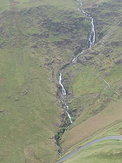
Moss Force is a waterfall situated within the Lake District National Park in the English county of Cumbria. It is located 10 km SW of the town of Keswick at Newlands Hause, the pass between the Newlands Valley and the Buttermere Valley. It is part of Alfred Wainwright's famous "Wainwright Memorial Walk," and its beauty was celebrated by Samuel Taylor Coleridge.

Martindale is a valley, village and civil parish in Cumbria, England, situated within the Lake District National Park between the lakes of Ullswater and Haweswater. The valley is served by a narrow minor road which runs as far as the farm of Dale Head. This road commences at Howtown, a hamlet on the shore of Ullswater that forms part of the civil parish but is not in the valley of Martindale, and passes over a mountain pass or hause into the valley.


