Mellbreak

Last updated

Mellbreak
Mellbreak from Grasmoor summit.JPG
Mellbreak seen from Grasmoor summit. Three km to the east.
Highest point
Elevation 512 m (1,680 ft)
Prominence 260 m (850 ft)
Parent peak High Stile
Listing Marilyn, Wainwright
Coordinates 54°33′20″N3°19′08″W / 54.55544°N 3.31889°W / 54.55544; -3.31889
Geography
Lake District National Park UK relief location map.png
Red triangle with thick white border.svg
Mellbreak
Location relief map United Kingdom Allerdale.svg
Red triangle with thick white border.svg
Mellbreak
Location in Allerdale, Cumbria
Location Cumbria, England
Parent range Lake District, Western Fells
OS grid NY148186
Topo map OS Landranger 89, Explorer OL4

Mellbreak is a hill in the Western part of the English Lake District. Despite being surrounded on all sides by higher fells (the Loweswater Fells, the High Stile Ridge and the Grasmoor Group), it stands in isolation. It is surrounded on three sides by a "moat" of deep marshy land, and on the east side by the lake of Crummock Water. The fell forms a partnership with the lake, running parallel to it, falling sheer into it, and regularly providing the backdrop for pictures of it.

Contents

Name

Mellbreak's name is derived from differing sources: the Celtic "moel", meaning "bare hill", and the later Old Norse of the Vikings, "brekka", which means a hill slope. [1]

Topography

The Western Fells occupy a triangular sector of the Lake District, bordered by the River Cocker to the north east and Wasdale to the south east. Westwards, the hills diminish toward the coastal plain of Cumberland. At the central hub of the high country are Great Gable and its satellites, while two principal ridges fan out on either flank of Ennerdale, the western fells in effect being a great horseshoe around this long wild valley. [2] Mellbreak and the other Loweswater Fells form the extremity of the northern arm.

The Loweswater Fells have been compared [2] to the digits of a hand, radiating out south westward from the "palm" centred on Loweswater village. From the west these are Burnbank Fell, Blake Fell, Gavel Fell, Hen Comb and Mellbreak, the "thumb". To continue the hand metaphor, the opposing thumb of Mellbreak is the tenuous northern extremity of Starling Dodd, whilst the other Loweswater Fells are satellites of Great Borne.

The fell has been likened (by Alfred Wainwright and others) to the shape of an upturned boat, having north and south tops of roughly equal height and a wide flat depression in between. On the eastern side the steep slopes run down directly to the shore of Crummock Water. Low Ling Crag, a rocky projection into the lake, is a continuation of outcrops higher up. Other crags rim the depression between the two tops.

The southern boundary is formed by Scale Beck and its tributary Black Beck. Mellbreak has a third much lower top overlooking this steep sided valley, Scale Kott (1,109 ft). At the head of Black Beck is the connection to Starling Dodd, running south west from Scale Knott. This could hardly be considered a ridge in walking terms, since it begins at the foot of an 800 ft scree slope on the northern flank of Starling Dodd.

To the west of Mellbreak is the marshy valley of Mosedale, its beck flowing north to Loweswater village. On the other side is the parallel ridge of Hen Comb. The northern end of Mellbreak rises direct from the valley behind the village, precipitous like a sand castle on a flat beach. From this vantage point its steep gabled profile is an arresting sight. The successive rock tiers of White, Dropping and Raven Crags complete the picture.

Geology

Mellbreak is formed primarily from the laminated mudstone and siltstone of the Kirkstile Formation. There is an intrusion of basalt on the Crummock face and the southern end around Scale Knott exhibit the Buttermere Formation. This is an olistostrome of disrupted, sheared and folded mudstone, siltstone and sandstone. The rocks of Hen Comb are of the Kirkstile Formation, laminated mudstone and siltstone, often associated with the Skiddaw group. [3]

There are two small trials for iron, one on each side of the fell. Neither penetrates for more than a few feet. [4]

Summit

Although the south top is slightly higher, at 512 m (1,680 ft) it is the north top (509 m, 1,670 ft) that is the better summit, being rocky and situated on the top of the crags that make up the north face of the fell. Both carry substantial cairns, that of the true summit being on grass. [2] The views are good from both summits, a consequence of Mellbreak's isolation and great relative height. The north top brings the Solway Firth into view, but otherwise the differences are mainly confined to the foreground. Grasmoor and Rannerdale Knotts look impressive across the lake, an unexpected glimpse of the Helvellyn range seen behind. [2]

Ascents

Mellbreak seen from the Kirkstile Inn, in Loweswater village Kirkstile Inn, Loweswater.jpg
Mellbreak seen from the Kirkstile Inn, in Loweswater village

A popular route up the fell is a path from the village of Loweswater, that threads its way between the crags and rocky outcrops on the north side. The north top is then traversed to reach the summit. A variation misses out the north top, following a slanting path southwards along the Mosedale face to the depression. From the shore of Crummock Water an ascent can be made following Pillar Rake, a diagonal breach in the central rim of crag. A direct climb of the south top direct is best achieved from Buttermere village, starting along the Scale Force path before making for Scale Knott. [2] [5]

Related Research Articles

<span class="mw-page-title-main">Dale Head</span>

Dale Head is a fell in the north-western sector of the Lake District, in northern England. It is 753 metres or 2,470 feet above sea level and stands immediately north of Honister Pass, the road between Borrowdale and Buttermere.

<span class="mw-page-title-main">Grasmoor</span> Mountain in the English Lake District, Cumbria, England

Grasmoor is a mountain in the north-western part of the Lake District, northern England. It is the highest peak in a group of hills between the villages of Lorton, Braithwaite and Buttermere, and overlooks Crummock Water.

<span class="mw-page-title-main">Crag Hill</span>

Crag Hill is a mountain in the North Western part of the English Lake District. It was formerly known as Eel Crag; however, the Ordnance Survey now marks Eel Crag as referring to the northern crags of the fell. It is not to be confused with another Crag Hill lying on the border of North Yorkshire.

<span class="mw-page-title-main">High Stile</span> Fell in the Lake District, Cumbria, England

High Stile is a mountain in the western part of the Lake District in North West England. It is the eleventh-highest English Marilyn, standing 807 metres (2,648 ft) high, and has a relative height of 362 metres (1,187 ft).

<span class="mw-page-title-main">Causey Pike</span> Mountain in the English Lake District, Cumbria, England

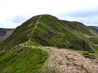
Causey Pike is a fell in the English Lake District. It is situated in the Newlands Valley, 5 km south-west of the town of Keswick. Even though it has a modest height of 637 metres (2,090 ft) it is one of the most distinctive fells when viewed from the Derwent Water and Keswick area due to its distinguishing summit "knobble" which catches the eye. The fell is one of 214 fells described by Alfred Wainwright in his series of Pictorial Guides to the Lakeland Fells: Causey Pike features in Book Six, The North Western Fells.

<span class="mw-page-title-main">Blake Fell</span>

Blake Fell is a hill in the Western part of the English Lake District. It is the highest point of the Loweswater Fells, an area of low grassy hills with steep sides overlooking the lake of Loweswater. The fell also overlooks the village of Loweswater, from which it can be climbed. An alternative route is from the Cogra Moss reservoir on its western slopes. Because the Loweswater Fells are a separate geographical unit, Blake Fell is a Marilyn. It is located in the Parish of Lamplugh.

<span class="mw-page-title-main">Crummock Water</span>

Crummock Water is a lake in the Lake District in North West England. It is 2.5 miles (4.0 km) long, 0.6 miles (0.97 km) wide, 140 feet (43 m) deep, and has an area of 2.5 square kilometres (0.97 sq mi). The lake's primary inflow is Buttermere Dubs, itself the outflow of Buttermere, and its outflow is the River Cocker, which meets the River Derwent at Cockermouth before entering the Irish Sea at Workington. It is in the unitary authority of Cumberland and the ceremonial county of Cumbria. It is in the parish of Buttermere, and its western shore forms part of the western boundary of the parish.

<span class="mw-page-title-main">Rannerdale Knotts</span>

Rannerdale Knotts is a fell in the Lake District of Cumbria, England. Rising from the Buttermere valley, it is one of the smaller Cumbrian hills and is overlooked by a number of surrounding fells, such as Grasmoor, Whiteless Pike and, across Crummock Water, Mellbreak and the High Stile ridge. Rannerdale Knotts is said to be the site of a battle between the native Cumbrians and Norsemen and the invading Normans in the late 11th or early 12th century.

<span class="mw-page-title-main">Low Fell (Lake District)</span>

Low Fell is a fell in the English Lake District. It overlooks the lake of Loweswater to the south and to the north is bordered by its neighbour Fellbarrow. It is usually climbed from the villages of Loweswater or Thackthwaite. The fell is largely occupied by grassed enclosures, although there are some rocky outcrops near the top. Low Fell has fairly steep slopes to the south and east.

<span class="mw-page-title-main">Red Pike (Buttermere)</span> Mountain in the English Lake District, Cumbria, England

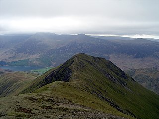
Red Pike is a fell in the High Stile range in the western English Lake District, which separates Ennerdale from the valley of Buttermere and Crummock Water. It is 2,476 ft (755 m) high. The direct ascent of Red Pike from Buttermere is very popular and the ridge walk from Red Pike to Haystacks is regarded as one of the finest in the area, with excellent views of the Scafells, Great Gable and Pillar.

<span class="mw-page-title-main">Whiteside (Lake District)</span>

Whiteside is a fell in the north-western area of the English Lake District. It stands at the western end of the Grisedale Pike- Hopegill Head ridge overlooking Crummock Water.

<span class="mw-page-title-main">Wandope</span> Fell in the Lake District, Cumbria, England

Wandope is a fell in the north-western area of the English Lake District. It lies to the east of Crummock Water and south of Crag Hill. From the summit there are excellent panoramas of the Sca Fell and High Stile ranges.

<span class="mw-page-title-main">Whiteless Pike</span> Fell in England

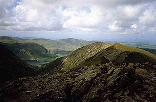
Whiteless Pike is a fell in the north-western English Lake District. It stands immediately east of Crummock Water and forms a pyramid shape when viewed from Rannerdale. In his celebrated guide to the Lakeland fells, Alfred Wainwright called it "the Weisshorn of Buttermere". There are good views of Great Gable and the Scafells from the summit.

<span class="mw-page-title-main">High Crag</span>

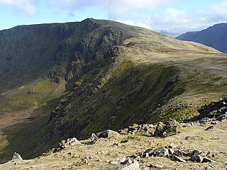
High Crag stands at the southern end of the High Stile ridge which divides the valleys of Ennerdale and Buttermere in the west of the English Lake District. It is often climbed as part of a popular ridge walk, from Black Sail youth hostel, or from Buttermere via Scarth Gap. Panoramas of the Great Gable and the Scafells are visible.

<span class="mw-page-title-main">Sail (Lake District)</span>

Sail is a hill in the English Lake District, lying between Derwentwater and Crummock Water.

<span class="mw-page-title-main">Burnbank Fell</span>

Burnbank Fell is a small hill in the west of the English Lake District. It is the most westerly of the Loweswater Fells, a group of low grassy hills just south of Loweswater. It is predominantly grassy, with sprawling flanks and a broad ridge connecting it to Blake Fell. It can be climbed from Lamplugh in the west, or from Waterend on the lakeshore.

<span class="mw-page-title-main">Hen Comb</span>

Hen Comb is a fell in the west of the English Lake District. One of the Loweswater Fells it lies to the south of Loweswater lake and Loweswater village. Although of only moderate height, its ascent can be difficult as it is largely surrounded by bogs.

<span class="mw-page-title-main">Starling Dodd</span>

Starling Dodd is a fell in the western part of the English Lake District, located between the valleys of Ennerdale and Buttermere, on the ridge between Great Borne to its west and Red Pike to its east. Not visible from Buttermere and rounded in profile, Starling Dodd is a relatively unfrequented top.

<span class="mw-page-title-main">Gavel Fell</span>

Gavel Fell is a hill in the English Lake District. Centremost of the five Loweswater Fells in the western part of the District, it stands between Hen Comb and Blake Fell. Of moderate altitude it can be climbed from Loweswater village, or from Croasdale to the west.

<span class="mw-page-title-main">Western Fells</span>

The Western Fells are a group of hills in the English Lake District. Centred on Great Gable they occupy a triangular area between Buttermere and Wasdale. The Western Fells are characterised by high ridges and an abundance of naked rock.

References

  1. Hawley, Robert (November–December 2008). "Lake District Life" [What's in a Lakeland Name?]: 28–29.{{cite journal}}: Cite journal requires |journal= (help)
  2. 1 2 3 4 5 Alfred Wainwright: A Pictorial Guide to the Lakeland Fells, Volume 7 The Western Fells: Westmorland Gazette (1966): ISBN   0-7112-2460-9
  3. British Geological Survey: 1:50,000 series maps, England & Wales Sheet 29: BGS (1999)
  4. Adams, John: Mines of the Lake District Fells: Dalesman (1995) ISBN   0-85206-931-6
  5. Bill Birkett: Complete Lakeland Fells: Collins Willow (1994): ISBN   0-00-713629-3