Lank Rigg

Last updated

Lank Rigg
Lank Rigg summit.jpg
Looking west from the summit
Highest point
Elevation 541 m (1,775 ft)
Prominence 111 m (364 ft)
Listing Wainwright
Coordinates 54°29′38″N3°24′11″W / 54.494°N 3.403°W / 54.494; -3.403
Geography
Lake District National Park UK relief location map.png
Red triangle with thick white border.svg
Lank Rigg
Location in the Lake District
Location relief map Borough of Copeland.svg
Red triangle with thick white border.svg
Lank Rigg
Location in Copeland Borough
Location Cumbria, England
Parent range Lake District, Western Fells
OS grid NY092119
Topo map OS Landranger 89, 90, Explorer OL4

Lank Rigg is a fell in the English Lake District. It stands to the south of Ennerdale in the Western Fells. A sprawling hill with gentle grassy slopes it can be climbed from various points on the Coldfell road. It carries various remains from ancient habitation.

Contents

Topography

The Western Fells occupy a triangular sector of the Lake District, bordered by the River Cocker to the north east and Wasdale to the south east. Westwards the hills diminish toward the coastal plain of Cumberland. At the central hub of the high country are Great Gable and its satellites, while two principal ridges fan out on either flank of Ennerdale, the western fells in effect being a great horseshoe around this long wild valley. [1] Lank Rigg is the highest of the group of fells at the extremity of the southern arm.

The main watershed runs broadly westwards from Great Gable, dividing the headwaters of Ennerdale and Wasdale. The fells in this section are Kirk Fell, Pillar, Scoat Fell, Haycock and Caw Fell. The surrounding valleys gradually diverge until other rivers spring up to drain the intervening country. Worm Gill is one such watercourse, running south westward from Caw Fell, and forcing the ridge to detour northwards around the head of its valley. Beyond this stand the fells of the Lank Rigg group, the final high country within the National Park. Crag Fell and Grike complete the westward line of the ridge, whilst Lank Rigg itself stands to the south across the head of the River Calder.

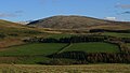
Lank Rigg occupies an upland area about 2 miles (3 km) square, bordered by the River Calder and Worm Gill to east and west. Worm Gill sweeps around the southern flank of the fell, joining the Calder at Thornholme to complete the moat on three sides. To the north east, via the subsidiary top of Whoap, 1,676 ft (511 m), is a connection to the main ridge. This joins it perpendicularly between Crag Fell and Caw Fell. The slopes of Lank Rigg are uniformly gentle, clad in grass with the occasional rash of stones. There is a small tarn just below the summit to the south west.

Although Wainwright [1] regarded only Lank Rigg as an independent summit, other guidebooks give equal prominence to Whoap and the western tops of Latterbarrow 1,161 ft (354 m) and Kinniside 1,230 ft (375 m). [2]

History

Lank Rigg carries the remains of ancient settlement with a tumulus near the summit and various enclosures and cairns near Tongue Bank. [1] These are marked as ‘cairn’, ‘settlement’ and ‘homestead’ on Ordnance Survey maps.

Summit

The highest point bears an Ordnance Survey triangulation column. The Lakeland view is uninspiring, apart from an unexpected appearance by distant Blencathra, but the coastal plain is well seen. [1]

To mark the completion of his Pictorial Guide to the Lakeland Fells , Alfred Wainwright buried a two-shilling (now ten pence) piece under a stone at the summit. He made mention of this in the last volume so that the first reader on the fell could collect the prize. It was, as he said, ‘a reckless thing to do’. [1] Visitors to the summit may still occasionally find coins hidden there by generous fellwalkers in memory of Wainwright’s act.

Ascents

The unfenced Coldfell road runs south from Ennerdale Bridge to Calder Bridge, providing the best access to Lank Rigg. A footpath leads off eastward between Blakeley Raise and Burn Edge, dropping into the upper Calder valley. This can then be followed to the col between Whoap and Lank Rigg. A circular outing can be devised from the same starting point, also visiting Crag Fell and Grike. [1] [2]

From further south on the road a lane gives access to the Calder just opposite Tongue How. A long ascent up the south western slopes then follows.

Related Research Articles

<span class="mw-page-title-main">Pillar (Lake District)</span> Mountain in the English Lake District, Cumbria, England

Pillar is a mountain in the western part of the English Lake District. Situated between the valleys of Ennerdale to the north and Wasdale to the south, it is the highest point of the Pillar group. At 892 metres (2,927 ft) it is the eighth-highest mountain in the Lake District. The fell takes its name from Pillar Rock, a prominent feature on the Ennerdale side, regarded as the birthplace of rock climbing in the district.

<span class="mw-page-title-main">Buckbarrow</span>

Buckbarrow is a small fell in the English Lake District overlooking the western end of Wastwater. It is featured in Alfred Wainwright’s Pictorial Guide to the Lakeland Fells and is given a height of 1,410 ft approximately; however, the Ordnance Survey and other guidebooks now give an altitude of 423 m (1,388 ft). The fell’s name means ‘The hill of the buck or goat’. It is derived either from the Old English word bucc meaning buck or the Old Norse word bokki meaning a male goat.

<span class="mw-page-title-main">High Stile</span> Fell in the Lake District, Cumbria, England

High Stile is a mountain in the western part of the Lake District in North West England. It is the eleventh-highest English Marilyn, standing 807 metres (2,648 ft) high, and has a relative height of 362 metres (1,188 ft).

<span class="mw-page-title-main">Kirk Fell</span> Fell in the Lake District, England

Kirk Fell is a fell in the Western part of the English Lake District. It is situated between Great Gable and Pillar on the long ring of fells surrounding the valley of Ennerdale, and also stands over Wasdale to the south. However, it is separated from its two higher neighbours by the low passes of Black Sail and Beck Head, giving it a high relative height and making it a Marilyn, the thirteenth highest in the Lake District.

<span class="mw-page-title-main">Seatallan</span>

Seatallan is a mountain in the western part of the English Lake District. It is rounded, grassy and fairly unassuming, occupying a large amount of land. However, it is classed as a Marilyn because of the low elevation of the col connecting it to Haycock, its nearest higher neighbour to the north. The name Seatallan is believed to have a Cumbric origin, meaning "Aleyn's high pasture".

<span class="mw-page-title-main">Blake Fell</span>

Blake Fell is a hill in the Western part of the English Lake District. It is the highest point of the Loweswater Fells, an area of low grassy hills with steep sides overlooking the lake of Loweswater. The fell also overlooks the village of Loweswater, from which it can be climbed. An alternative route is from the Cogra Moss reservoir on its western slopes. Because the Loweswater Fells are a separate geographical unit, Blake Fell is a Marilyn. It is located in the Parish of Lamplugh.

<span class="mw-page-title-main">Red Pike (Buttermere)</span> Mountain in the English Lake District, Cumbria, England

Red Pike is a fell in the High Stile range in the western English Lake District, which separates Ennerdale from the valley of Buttermere and Crummock Water. It is 2,476 ft (755 m) high. The direct ascent of Red Pike from Buttermere is very popular and the ridge walk from Red Pike to Haystacks is regarded as one of the finest in the area, with excellent views of the Scafells, Great Gable and Pillar.

<span class="mw-page-title-main">Red Pike (Wasdale)</span> Mountain in the English Lake District, Cumbria, England

Red Pike is a fell in the English Lake District. It is 826 m or 2,709 ft high and lies due north of Wast Water. It is often climbed as part of the Mosedale Horseshoe, a walk which also includes Pillar.

<span class="mw-page-title-main">Scoat Fell</span> Mountain in the English Lake District, Cumbria, England

Scoat Fell is a fell in the western part of the English Lake District. It stands at the head of the Mosedale Horseshoe with its back to Ennerdale. Paths lead to Scoat Fell from Ennerdale over Steeple, from Wasdale over Red Pike, and along the ridge from Pillar.

<span class="mw-page-title-main">Green Gable</span> Mountain in the Lake District, England

Green Gable is a fell in the English Lake District often traversed by walkers en route to its more famous neighbour Great Gable. It can be ascended from Honister Pass, Seathwaite in Borrowdale, or Ennerdale. There are good views of Gable Crag, Scafell Pike and the Buttermere valley from the summit.

<span class="mw-page-title-main">Yewbarrow</span> Mountain in the English Lake District, Cumbria, England

Yewbarrow is a fell, in the English Lake District, which lies immediately north of the head of Wast Water. It is 628 metres high and in shape resembles the upturned hull of a boat or a barrow. Yewbarrow is on the left in the classic view of Great Gable and Wast Water.

<span class="mw-page-title-main">Haycock (Lake District)</span> Fell in the Lake District, Cumbria, England

Haycock is a mountain in the western part of the English Lake District. It rises between Scoat Fell and Caw Fell to the south of Ennerdale and the north of Wasdale. Haycock is an imposing dome-shaped fell, its popularity with walkers diminished somewhat by its remoteness. It can be climbed from either valley and offers fine mountain views.

<span class="mw-page-title-main">Grike (Lake District)</span> Fell in the Lake District, England

Grike is a hill in the west of the English Lake District, near Ennerdale Water. It is part of the Lank Rigg group, the most westerly Wainwright as the fells diminish toward the coastal plain. It can be climbed from Kinniside or Ennerdale Bridge.

<span class="mw-page-title-main">Starling Dodd</span>

Starling Dodd is a fell in the western part of the English Lake District, located between the valleys of Ennerdale and Buttermere, on the ridge between Great Borne to its west and Red Pike to its east. Not visible from Buttermere and rounded in profile, Starling Dodd is a relatively unfrequented top.

<span class="mw-page-title-main">Brandreth</span> Fell in the Lake District, Cumbria, England

Brandreth is a fell in the English Lake District. It stands between Great Gable and Haystacks in the Western Fells.

<span class="mw-page-title-main">Caw Fell</span> Fell in the Lake District, Cumbria, England

Caw Fell is a fell in the English Lake District, standing between Haycock the Lank Rigg group. It occupies a wide upland area with Ennerdale to the north and Blengdale to the south. Caw Fell is distant from any point of access by Lakeland standards, but can be climbed from Blengdale or Bowness Knott car-parks.

<span class="mw-page-title-main">Crag Fell</span> Fell in the Lake District, England

Crag Fell is a hill in the English Lake District. It is part of the Lank Rigg group, standing above Ennerdale Water in the Western Fells. The craggy northern face above the lake gives the fell its name, prominent in views from the car park at Bowness Knott. Ascents are commonly made from the foot of Ennerdale Water.

Middle Fell is a hill or fell in the English Lake District. It is a satellite of Seatallan standing above the northern shore of Wastwater. Middle Fell can be climbed from Greendale near the foot of Wastwater, and a fine view of the lake backed by the Wastwater Screes is visible from the summit.

<span class="mw-page-title-main">Iron Crag</span>

Iron Crag is a mountain in the English Lake District, standing between Crag Fell and Caw Fell. The name of the fell is the source of some confusion, as the summit is unnamed on Ordnance Survey maps. Iron Crag apparently refers to the rocky outcrop below the summit, while the lower slopes are referred to as Ennerdale Fell. The Western aspect of the lower slopes, facing Ennerdale Water is known as The Side.

<span class="mw-page-title-main">Western Fells</span>

The Western Fells are a part of the Cumbrian Mountains in the Lake District of England. Centred on Great Gable they occupy a triangular area between Buttermere and Wasdale. The Western Fells are characterised by high ridges and an abundance of naked rock.

References

  1. 1 2 3 4 5 6 Alfred Wainwright: A Pictorial Guide to the Lakeland Fells, Volume 7 The Western Fells: Westmorland Gazette (1966): ISBN   0-7112-2460-9
  2. 1 2 Bill Birkett: Complete Lakeland Fells: Collins Willow (1994): ISBN   0-00-713629-3