Low Fell (Lake District)

Last updated

Low Fell
Low fell.jpg
Low Fell from Thackthwaite
Highest point
Elevation 423 m (1,388 ft)
Prominence c. 270 m
Parent peak High Stile
Listing Wainwright, Marilyn
Coordinates 54°35′28″N3°20′13″W / 54.59119°N 3.33707°W / 54.59119; -3.33707 Coordinates: 54°35′28″N3°20′13″W / 54.59119°N 3.33707°W / 54.59119; -3.33707
Geography
Lake District National Park UK relief location map.png
Red triangle with thick white border.svg
Low Fell
Location relief map United Kingdom Allerdale.svg
Red triangle with thick white border.svg
Low Fell
Location in Allerdale, Cumbria
Location Cumbria, England
Parent range Lake District, Western Fells
OS grid NY137226
Topo map OS Landranger 89, Explorer OL4

Low Fell is a fell in the English Lake District. It overlooks the lake of Loweswater to the south and to the north is bordered by its neighbour Fellbarrow. It is usually climbed from the villages of Loweswater or Thackthwaite. The fell is largely occupied by grassed enclosures, although there are some rocky outcrops near the top. Low Fell has fairly steep slopes to the south and east.

Contents

Topography

The Western Fells occupy a triangular sector of the Lake District, bordered by the River Cocker to the north east and Wasdale to the south east. Westwards, the hills diminish towards the coastal plain of Cumberland. At the central hub of the high country are Great Gable and its satellites, while two principal ridges fan out on either flank of Ennerdale, the western fells in effect being a great horseshoe around this long wild valley. [1] Low Fell and Fellbarrow stand remote from the end of the northern arm.

Loweswater is unique amongst the major lakes of the District in emptying towards the centre of the National Park. Its waters flow out eastwards into Crummock Water before beginning their northward journey as the Cocker. Loweswater does not therefore represent any watershed between the fells on either side of its valley, as might be supposed from a quick glance at the map. A low ridge circuiting the western end of the lake joins Burnbank Fell to Low Fell and Fellbarrow, confirming them as the last outpost of the Western Fells.

Low Fell and Fellbarrow form a ridge two miles long, with the somewhat contrarily named Low Fell being the higher. Alfred Wainwright in his influential Pictorial Guide to the Lakeland Fells was forced to estimate the elevation of Low Fell and considered it (albeit doubtfully) to be inferior to Fellbarrow. New mapping by the Ordnance Survey has now settled the issue. [1] The lowest col on the ridge occurs immediately south of Fellbarrow, and the intervening tops are therefore usually considered satellites of Low Fell. [1] These lower summits, working southward, are Smithy Fell (1,296 ft) and Sourfoot Fell (1,350 ft).

The southern terminus of the ridge, looking down on Loweswater village, is rough on all sides, rising to a small neat top. This was considered the summit by Wainwright, although again he was unsure and ill-served by the maps of the time. Birkett refers to this 1,352 ft top as Loweswater Fell, although without any particular justification. [2] North of this point is a slight depression before the smoother and more elongated true summit.

A subsidiary ridge breaks off south-west from Sourfoot Fell, crossing the slight hump of Loftbarrow before reaching Darling Fell (1,282 ft). This stands over the northern shore of Loweswater, about halfway up the lake. Between Darling Fell and Low Fell is the little valley of Crabtree Beck. In general, the western slopes of the Low Fell ridge are long and gentle, while some rock appears along the steeper eastern and southern flanks.

The western boundary of the fell proper lies at Leady Moss, the low point on the connecting ridge to Burnbank Fell. From here, the Dub Beck flows into Loweswater while the Black Beck flows north-west into the River Marron. The open fellside is circumscribed by a minor road which runs from the shore of Loweswater north to Mosser. In the east, the slopes fall quickly to the cultivated lands of the broad Vale of Lorton. Raven Crag below the summit and Watching Crag on Sourfoot Fell are the main features.

Geology

The rocks beneath the summit are of the Loweswater Formation, composed of greywacke sandstone turbidities. Beneath this and occasionally outcropping on the eastern flanks are the laminated mudstone and siltstone of the Kirk Stile Formation. [3]

Summit

Wainwright described the view from the lower southern top, noting that two cairns lower down the southern face gave better vantage points for the Loweswater Valley. From either summit, there are views to Grasmoor, across the Lorton Vale and down the Buttermere valley in which you can see Crummock Water and Buttermere.

Both tops are marked by cairns; the true summit top being on a small outcrop amid short fell grass and large rocks. [1] [2]

Ascents

The gentlest way onto the ridge is from Thackthwaite in the Vale of Lorton. A footpath leads away from the settlement climbing to the intake wall. Beyond is a drove road, curving up the hillside to emerge at the top of Sourfoot Fell. The ridge from here is easy. An alternative start is from the Mosser road, climbing Darling Fell before joining the main ridge. Wainwright also suggests following Crabtree Beck for a direct ascent of Low Fell. [1] [2]

Ownership

Land Registry records show that Low Fell, Raven Crag and surrounding lands that formed part of Oak Farm were in the ownership of the Master and Scholars of Balliol College in the University of Oxford. The title changing hands to John Gladstone Mitchel of Cockermouth in 1959. Low Fell and Raven Crag are now in the ownership of Buy Land Plant Trees CIC, a subsidiary of Chimney Sheep Ltd.

Nature Reserve

In 2020/21 a large portion of the Fell was acquired by Buy Land Plant Trees CIC to 'hand it back to nature'. The previously dilapidated fencing has been replaced and sheep access prevented creating a nature reserve. Planting of scrub (hawthorn, birch, blackthorn, rowan, etc) started in 2021/22 with the eventual aim of creating a mosaic landscape of scrub/trees and open areas of moorland and peat bog.

Change to land management

Since the acquisition of the fell by Buy Land Plant Trees CIC all sheep have been excluded to allow natural regeneration of grazing inhibited plant species. To further protect the regeneration of the site and ensure nature is the main beneficiary all access by fox hounds and hunters (including trail hunting) is prohibited.

Related Research Articles

<span class="mw-page-title-main">Robinson (Lake District)</span>

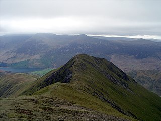
Robinson is a fell in the English Lake District, its southern slopes descending to Buttermere, while its northern side is set in the Newlands Valley. Paths lead to the summit from the village of Buttermere, from the nearby summit Dale Head and from various locations in the valleys to the north.

<span class="mw-page-title-main">Grasmoor</span> Mountain in the English Lake District, Cumbria, England

Grasmoor is a mountain in the north-western part of the Lake District, northern England. It is the highest peak in a group of hills between the villages of Lorton, Braithwaite and Buttermere, and overlooks Crummock Water.

<span class="mw-page-title-main">Crag Hill</span>

Crag Hill is a mountain in the North Western part of the English Lake District. It was formerly known as Eel Crag; however, the Ordnance Survey now marks Eel Crag as referring to the northern crags of the fell. It is not to be confused with another Crag Hill lying on the border of North Yorkshire.

<span class="mw-page-title-main">High Stile</span> Fell in the Lake District, Cumbria, England

High Stile is a mountain in the western part of the Lake District in North West England. It is the eleventh-highest English Marilyn, standing 807 metres (2,648 ft) high, and has a relative height of 362 metres (1,187 ft).

<span class="mw-page-title-main">Blake Fell</span>

Blake Fell is a hill in the Western part of the English Lake District. It is the highest point of the Loweswater Fells, an area of low grassy hills with steep sides overlooking the lake of Loweswater. The fell also overlooks the village of Loweswater, from which it can be climbed. An alternative route is from the Cogra Moss reservoir on its western slopes. Because the Loweswater Fells are a separate geographical unit, Blake Fell is a Marilyn. It is located in the Parish of Lamplugh.

<span class="mw-page-title-main">Mellbreak</span>

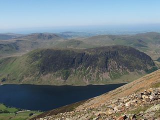
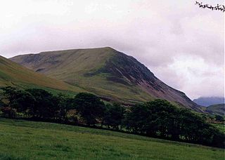
Mellbreak is a hill in the Western part of the English Lake District. Despite being surrounded on all sides by higher fells, it stands in isolation. It is surrounded on three sides by a "moat" of deep marshy land, and on the east side by the lake of Crummock Water. The fell forms a partnership with the lake, running parallel to it, falling sheer into it, and regularly providing the backdrop for pictures of it.

<span class="mw-page-title-main">Red Pike (Buttermere)</span> Mountain in the English Lake District, Cumbria, England

Red Pike is a fell in the High Stile range in the western English Lake District, which separates Ennerdale from the valley of Buttermere and Crummock Water. It is 2,476 ft (755 m) high. The direct ascent of Red Pike from Buttermere is very popular and the ridge walk from Red Pike to Haystacks is regarded as one of the finest in the area, with excellent views of the Scafells, Great Gable and Pillar.

<span class="mw-page-title-main">Whiteside (Lake District)</span>

Whiteside is a fell in the north-western area of the English Lake District. It stands at the western end of the Grisedale Pike- Hopegill Head ridge overlooking Crummock Water.

<span class="mw-page-title-main">Wandope</span> Fell in the Lake District, Cumbria, England

Wandope is a fell in the north-western area of the English Lake District. It lies to the east of Crummock Water and south of Crag Hill. From the summit there are excellent panoramas of the Sca Fell and High Stile ranges.

<span class="mw-page-title-main">Whiteless Pike</span> Fell in England

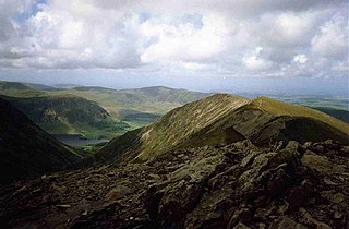
Whiteless Pike is a fell in the north-western English Lake District. It stands immediately east of Crummock Water and forms a pyramid shape when viewed from Rannerdale. In his celebrated guide to the Lakeland fells, Alfred Wainwright called it "the Weisshorn of Buttermere". There are good views of Great Gable and the Scafells from the summit.

<span class="mw-page-title-main">High Crag</span>

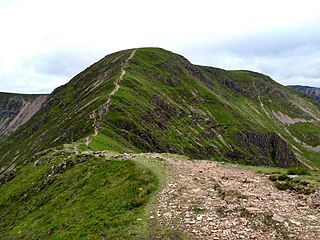
High Crag stands at the southern end of the High Stile ridge which divides the valleys of Ennerdale and Buttermere in the west of the English Lake District. It is often climbed as part of a popular ridge walk, from Black Sail youth hostel, or from Buttermere via Scarth Gap. Panoramas of the Great Gable and the Scafells are visible.

<span class="mw-page-title-main">Great Borne</span>

Great Borne is a fell in the English Lake District with a height of 616 m (2,021 ft). It is a rather secluded hill situated at the western end of the long ridge which divides the Ennerdale and Buttermere valleys.

<span class="mw-page-title-main">Sail (Lake District)</span>

Sail is a hill in the English Lake District, lying between Derwentwater and Crummock Water.

<span class="mw-page-title-main">Broom Fell</span>

Broom Fell is a small hill in the English Lake District. It lies on a ridge connecting Lord's Seat and Graystones, but is rarely climbed. Alfred Wainwright did however accord it the status of a separate fell in his influential guidebook series, the Pictorial Guide to the Lakeland Fells.

<span class="mw-page-title-main">Fellbarrow</span>

Fellbarrow is a low hill in the north west of the English Lake District. It is not far from the town of Cockermouth, near to Loweswater and can most easily be climbed from Low Lorton, or Thackthwaite. From the summit there are views across the Lorton valley to Grasmoor and Whiteside.

<span class="mw-page-title-main">Burnbank Fell</span>

Burnbank Fell is a small hill in the west of the English Lake District. It is the most westerly of the Loweswater Fells, a group of low grassy hills just south of Loweswater. It is predominantly grassy, with sprawling flanks and a broad ridge connecting it to Blake Fell. It can be climbed from Lamplugh in the west, or from Waterend on the lakeshore.

<span class="mw-page-title-main">Hen Comb</span>

Hen Comb is a fell in the west of the English Lake District. One of the Loweswater Fells it lies to the south of Loweswater lake and Loweswater village. Although of only moderate height, its ascent can be difficult as it is largely surrounded by bogs.

<span class="mw-page-title-main">Starling Dodd</span>

Starling Dodd is a fell in the western part of the English Lake District, located between the valleys of Ennerdale and Buttermere, on the ridge between Great Borne to its west and Red Pike to its east. Not visible from Buttermere and rounded in profile, Starling Dodd is a relatively unfrequented top.

<span class="mw-page-title-main">Gavel Fell</span>

Gavel Fell is a hill in the English Lake District. Centremost of the five Loweswater Fells in the western part of the District, it stands between Hen Comb and Blake Fell. Of moderate altitude it can be climbed from Loweswater village, or from Croasdale to the west.

<span class="mw-page-title-main">Western Fells</span>

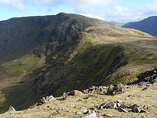
The Western Fells are a group of hills in the English Lake District. Centred on Great Gable they occupy a triangular area between Buttermere and Wasdale. The Western Fells are characterised by high ridges and an abundance of naked rock.

References

  1. 1 2 3 4 5 Alfred Wainwright: A Pictorial Guide to the Lakeland Fells, Volume 7 The Western Fells: Westmorland Gazette (1966): ISBN   0-7112-2460-9
  2. 1 2 3 Birkett, Bill: Complete Lakeland Fells: Collins Willow (1994): ISBN   0-00-218406-0
  3. British Geological Survey: 1:50,000 series maps, England & Wales Sheet 29: BGS (1999)