Ascent and summit
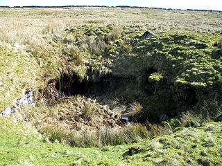
The fell is crossed by many high wire-topped dry-stone walls, which can make attaining the highest point of the fell awkward. Routes to the summit start at Muker, Thwaite and Keld and the bridleway should be used to attain the summit plateau where it joins a high wall that can be followed north to the summit of the fell, which is marked by a substantial cairn, although the highest point seems to be a few metres east of it. 100 metres east of the summit is a five-metre-deep shake hole, which is marked on the Ordnance Survey map as a pothole, so the depression may go much deeper on closer investigation.
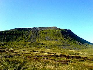
The grass- and heather-covered summit gives a good all-round view, with the bulk of Rogan's Seat including the great gash of Swinner Gill dominating to the east while Great Shunner Fell and Lovely Seat, with the Buttertubs Pass in between, show well to the south-west. To conclude the day walkers can descend eastwards to the Pennine Way and see the impressive waterfalls around Keld, namely Kisdon Force, East Gill Force, Catrake Force and Wain Wath Force.

The Pennine Way is a National Trail in England, with a small section in Scotland. The trail stretches for 268 miles (431 km) from Edale, in the northern Derbyshire Peak District, north through the Yorkshire Dales and Northumberland National Park and ends at Kirk Yetholm, just inside the Scottish border. The path runs along the Pennine hills, sometimes described as the "backbone of England". Although not the United Kingdom's longest National Trail, it is, according to The Ramblers, "one of Britain's best known and toughest".
The mountains of Whernside, Ingleborough and Pen-y-ghent are collectively known as the Three Peaks. The peaks, which form part of the Pennine range, encircle the head of the valley of the River Ribble in the Yorkshire Dales National Park in the North of England.

The River Swale in Yorkshire, England, is a major tributary of the River Ure, which becomes the River Ouse, that empties into the North Sea via the Humber Estuary. The river gives its name to Swaledale, the valley through which it flows.

Cross Fell is the highest mountain in the Pennines of Northern England and the highest point in England outside the Lake District. It is located in the North Pennines Area of Outstanding Natural Beauty. It lies within the county of Cumbria and the historic county boundaries of Cumberland.

Swaledale is a valley in North Yorkshire, England. It is one of the Yorkshire Dales, which are part of the Pennines, and within the Yorkshire Dales National Park. It is named after the River Swale, which runs through it. Swaledale is the most northerly of the major dales.

Tan Hill is a high point on the Pennine Way in the Richmondshire district of North Yorkshire, England. It lies north of Keld in the civil parish of Muker, near the borders of County Durham and Westmorland, and close to the northern boundary of the Yorkshire Dales National Park. It fell within the historic boundaries of the North Riding of Yorkshire. It is in an isolated location, the nearest town of Kirkby Stephen being an 11-mile (18 km) drive away.

Great Shunner Fell is the third-highest mountain in the Yorkshire Dales, North Yorkshire, England, and the highest point in Wensleydale; at 716 metres above sea level. In clear weather the summit affords views of Wensleydale to the south, Ribblesdale to the southwest and Swaledale to the north, as well as views into Cumbria and County Durham beyond the A66.

The Pennine Bridleway is a National Trail in Northern England.

Keld is a village in the English county of North Yorkshire. It is in Swaledale, and the Yorkshire Dales National Park. The name derives from the Viking word Kelda meaning a spring and the village was once called Appletre Kelde – the spring near the apple trees.

Nine Standards Rigg is the summit of Hartley Fell in the Pennine Hills of England. It lies near the boundary between Cumbria and North Yorkshire, a few miles south-east of Kirkby Stephen and approximately 770 yards (700 m) outside the Yorkshire Dales National Park. Nine Standards Rigg lies within the North Pennines Area of Outstanding Natural Beauty (AONB). The name is derived from a group of cairns, the Nine Standards, located near the summit. The fell is listed as Nine Standards Rigg, rather than Hartley Fell, in Alan Dawson's book The Hewitts and Marilyns of England.

Kisdon Force is a series of waterfalls on the River Swale in Swaledale, England. The falls are situated within the Yorkshire Dales National Park in the county of North Yorkshire, 500 metres downstream from the small hamlet of Keld at grid reference NY898010.

Lovely Seat, originally known as Lunasett until being misnamed by map makers some time in the twentieth century, is a fell in the Yorkshire Dales National Park in North Yorkshire, England. It reaches a height of 675 metres (2,215 feet). It is situated at grid reference SD878950 three miles north of the town of Hawes, and is part of the high ground which separates Wensleydale from Swaledale. It is the highest point of Abbotside Common. The fell is separated from its neighbour to the west, Great Shunner Fell, by the Buttertubs Pass which carries the minor motor road between Hawes in Wensleydale and Thwaite in Swaledale. The name Lunasett derives from the Norse dialect moon pasture; Commoners of Abbotside still use the original name.

East Gill Force is a waterfall in Swaledale, 330 yards (300 m) east of the hamlet of Keld, in the Yorkshire Dales National Park, North Yorkshire, England. The falls are located on East Gill at grid reference NY896012, just before its confluence with the River Swale at the point where the Pennine Way and the Coast to Coast Walk intersect. The falls are a popular spot for visitors, not just long-distance walkers but also families and picnickers because of the proximity of the road. East Gill Force has two main torrents: the upper falls have an impressive 15-foot (4.5 m) drop whilst the lower section is a series of stepped cascades that fall 9.8 feet (3 m) as East Gill enters the River Swale.

Wild Boar Fell is a mountain in the Yorkshire Dales National Park, on the eastern edge of Cumbria, England. At 2,323 feet (708 m), it is either the fourth-highest fell in the Yorkshire Dales or the fifth, depending on whether nearby High Seat is counted or not.
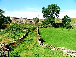
Angram is a hamlet in the Yorkshire Dales in the Richmondshire district of North Yorkshire, England. It is near Keld to the north and Thwaite to the south. Angram forms part of the civil parish of Muker.

Baugh Fell is a large, flat-topped hill in the northern Pennines of England. It lies in the north-western corner of the Yorkshire Dales National Park, immediately to the east of the Howgill Fells and to the north of Whernside, the highest of the Yorkshire Three Peaks. Formerly in the West Riding of Yorkshire, since 1974 it has been part of the county of Cumbria.

The mountains and hills of England comprise very different kinds of terrain, from a mountain range which reaches almost 1,000 metres high, to several smaller areas of lower mountains, foothills and sea cliffs. Most of the major upland areas have been designated as Areas of Outstanding Natural Beauty (AONB) or national parks. The highest and most extensive areas are in the north and west, while the midlands, south-east and east of the country tend to be low-lying.

Fountains Fell is a mountain in the Yorkshire Dales, England. The main summit has a height of 668 metres (2,192 ft) and a relative height or topographic prominence of 243 metres (797 ft) and thus qualifies as a Marilyn. Its subsidiary, Fountains Fell South Top reaches 662 metres (2,172 ft) and qualifies as a Nuttall. A third summit, further south at SD868697, reaches 610 metres (2,001 ft) and is the most southerly 2,000 ft summit in the Pennines.
Langcliffe Pot is a cave system on the slopes of Great Whernside in Upper Wharfedale, about 3 kilometres (1.9 mi) SSE of Kettlewell in North Yorkshire. It is part of the Black Keld Site of Special Scientific Interest where the "underground drainage system which feeds the stream resurgence at Black Keld is one of the largest and deepest in Britain, although only a small proportion of its cave passages are accessible at present." Mossdale Caverns is also part of the Black Keld SSSI. Although a considerable length of passage has been explored in Langcliffe Pot, the current end is over 170 metres (560 ft) above the resurgence, and over 4 kilometres (2.5 mi) in distance. A trip to the far end has been described as "one of the most serious undertakings in British caving".
The geology of the Yorkshire Dales National Park in northern England largely consists of a sequence of sedimentary rocks of Ordovician to Permian age. The core area of the Yorkshire Dales is formed from a layer-cake of limestones, sandstones and mudstones laid down during the Carboniferous period. It is noted for its karst landscape which includes extensive areas of limestone pavement and large numbers of caves including Britain's longest cave network.


