
Scafell Pike is the highest and the most prominent mountain in England, at an elevation of 978 metres (3,209 ft) above sea level. It is located in the Lake District National Park, in Cumbria, and is part of the Southern Fells and the Scafell massif.

Skiddaw is a mountain in the Lake District National Park in England. Its 931-metre (3,054 ft) summit is the sixth-highest in England. It lies just north of the town of Keswick, Cumbria, and dominates the skyline in this part of the northern lakes. It is the simplest of the Lake District mountains of this height to ascend and, as such, many walking guides recommend it to the occasional walker wishing to climb a mountain. This is the first summit of the fell running challenge known as the Bob Graham Round when undertaken in a clockwise direction.

Kielder Forest is a large forestry plantation in Northumberland, England, surrounding Kielder village and the Kielder Water reservoir. It is the largest man-made woodland in England with three-quarters of its 250 square miles (650 km2) covered by forest. The majority of the forest lies within Kielder Water and Forest Park, with the southern tip known as Wark Forest lying within Northumberland National Park. The forest is next to the England - Scotland border.

The Old Man of Coniston is a fell in the Furness Fells of the Lake District in Cumbria, England, and is the highest point of the historic county of Lancashire. It is at least 2,632.62 feet (802.42 m) high, and lies to the west of the village of Coniston and the lake, Coniston Water. The fell is sometimes known by the alternative name of Coniston Old Man, or simply The Old Man. The mountain is popular with tourists and fell-walkers with a number of well-marked paths to the summit. The mountain has also seen extensive copper and slate mining activity for eight hundred years, and the remains of abandoned mines and spoil tips are a significant feature of the north-east slopes.

Pillar is a mountain in the western part of the English Lake District. Situated between the valleys of Ennerdale to the north and Wasdale to the south, it is the highest point of the Pillar group. At 892 metres (2,927 ft) it is the eighth-highest mountain in the Lake District. The fell takes its name from Pillar Rock, a prominent feature on the Ennerdale side, regarded as the birthplace of rock climbing in the district.

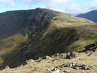
Fairfield is a fell in the English Lake District. It is the highest of a group of hills in the Eastern Fells, standing to the south of the Helvellyn range.

Whitbarrow is a hill in Cumbria, England, designated a biological Site of Special Scientific Interest and national nature reserve, forming part of the Morecambe Bay Pavements Special Area of Conservation due to its supporting some of the best European examples of natural limestone habitats. Also known as Whitbarrow Scar, the hill lies about 9 kilometres (5.6 mi) southwest of Kendal, just north of the A590 road, close to the village of Witherslack. Part of the site is a local nature reserve called Whitbarrow Scar. Whitbarrow's summit, known as Lord's Seat, is at 215 metres (705 ft) and has a prominence of 182 metres (597 ft), classifying it as a Marilyn.
High Stile is a mountain in the western part of the Lake District in North West England. It is the eleventh-highest English Marilyn, standing 807 metres (2,648 ft) high, and has a relative height of 362 metres (1,188 ft).

Binsey is a hill on the northern edge of the Lake District in Cumbria, England. It is detached from the rest of the Lakeland hills, and thus provides a good spot to look out at the Northern and North Western Fells of the Lake District, as well as the coastal plain and, across the Solway Firth, Scotland. Snaefell on the Isle of Man is also visible on a clear day. It is the northernmost of the Wainwrights.

Grisedale Pike is a fell in the Lake District, Cumbria, England, situated 4+1⁄2 miles west of the town of Keswick in the north-western sector of the national park. At a height of 791 metres it is the 40th-highest Wainwright in the Lake District; it also qualifies as a Hewitt, Marilyn and Nuttall. Grisedale Pike presents a striking appearance when viewed from the east, particularly from the vicinity of Keswick. It possesses two subsidiary summits: one unnamed ; the other Hobcarton End.

Crag Hill is on the western edge of the Yorkshire Dales in northern England, not to be confused with the higher Crag Hill elsewhere in the county of Cumbria. It lies on the boundary of the Yorkshire Dales national park, but its summit is in South Lakeland district, Cumbria. It is part of a ridge including the neighbouring fells of Great Coum and Gragareth. The summit of Crag Hill is about 0.62 miles (1 km) away from the top of Great Coum, the latter being the highest point on the ridge at 2,254 feet (687 m).

Glaramara is a fell in the English Lake District in Cumbria. It is a substantial fell that is part of a long ridge that stretches for over six kilometres from Stonethwaite in Borrowdale up to the important mountain pass of Esk Hause. The summit of Glaramara at 783 metres (2,569 ft) is the central point of this ridge, which separates the valleys of Langstrath and Grains Gill. However, the ridge has two additional fells, numerous subsidiary tops and several small tarns making its traverse an appealing and challenging walk.

Hopegill Head is a fell in the English Lake District in Cumbria. It is located nine kilometres west of the town of Keswick and is well seen from the B5292 road which crosses the Whinlatter Pass.

Muncaster Fell is a fell at the far western edge of the Lake District National Park, in Cumbria, England. Muncaster Fell is a long, narrow ridge of land, approximately 1.2 km wide and 6 km long, lying between the River Mite to the north, and River Esk to the south. The fell rises from the coast near Ravenglass village to its highest point at Hooker Crag (231 m). The ridge then continues to the north-east, dropping gently to its furthest prominence at Silver Knott (174 m). The fell then falls away rapidly to the village of Eskdale Green at its north-eastern tip.

The mountains and hills of England comprise very different kinds of terrain, from a mountain range which reaches almost 1,000 metres high, to several smaller areas of lower mountains, foothills and sea cliffs. Most of the major upland areas have been designated as Areas of Outstanding Natural Beauty (AONB) or national parks. The highest and most extensive areas are in the north and west, while the midlands, south-east and east of the country tend to be low-lying.

Peel Fell is the highest hill in the Kielder Forest region of England, making it the highest hill for several miles in each direction until the Cheviot Hills to the north-east are reached. Because of this, it has enough relative height to make it a Marilyn. It lies in both the county of Northumberland and the county of Roxburghshire, which is now governed by the Scottish Borders council, as the summit is on the border with Scotland.

Top o'Selside is a hill in the Lake District in Cumbria, England. At 335 metres (1,099 ft), it is the highest point of the group of hills situated between Coniston Water and Windermere. This group also includes the Wainwright of Black Fell and the summits of Black Brows and Rusland Heights. Top o'Selside lies not in the centre of this region, but in the south-western corner, just outside the forestry plantations of Grizedale Forest and only two-thirds of a mile from the eastern shore of Coniston Water. This large separation from any higher ground gives it enough relative height to make it a Marilyn.

Lambrigg Fell is a hill, the highest point of the area of high ground between Kendal and the M6, in south-eastern Cumbria, England.

