Alfred Wainwright MBE, who preferred to be known as A. Wainwright or A.W., was a British fellwalker, guidebook author and illustrator. His seven-volume Pictorial Guide to the Lakeland Fells, published between 1955 and 1966 and consisting entirely of reproductions of his manuscript, has become the standard reference work to 214 of the fells of the English Lake District. Among his 40-odd other books is the first guide to the Coast to Coast Walk, a 182-mile (293-kilometre) long-distance footpath devised by Wainwright which remains popular today.

The Pennines, also known as the Pennine Chain or Pennine Hills, are a range of uplands mainly located in Northern England. Commonly described as the "backbone of England" because of its length and position, the range runs from the north Midlands to North East England, near the Anglo-Scottish border. The Peak District is the southern end of the range, rising northwards from its foothills near the Trent Valley in northern Staffordshire, and further north into eastern Cheshire and southern Derbyshire. Beyond this are the South Pennines, Yorkshire Dales, and North Pennines, ending at the Tyne Gap. Beyond the gap are the Border Moors and Cheviot Hills, which are included in some definitions of the range.

A fell is a high and barren landscape feature, such as a mountain or moor-covered hill. The term is most often employed in Fennoscandia, Iceland, the Isle of Man, parts of northern England, and Scotland.
The mountains of Whernside, Ingleborough and Pen-y-ghent are collectively known as the Three Peaks. The peaks, which form part of the Pennine range, encircle the head of the valley of the River Ribble in the Yorkshire Dales National Park in the North of England.

Cross Fell is the highest mountain in the Pennines of Northern England and the highest point in England outside the Lake District. It is located in the North Pennines Area of Outstanding Natural Beauty. It lies within the county of Cumbria and the historic county boundaries of Cumberland.

Great Shunner Fell is the third highest mountain in the Yorkshire Dales, North Yorkshire, England, and the highest point in Wensleydale; at 716 metres above sea level. In clear weather the summit affords views of Wensleydale to the south, Ribblesdale to the south west and Swaledale to the north, as well as views into Cumbria and County Durham beyond the A66.

England comprises most of the central and southern two-thirds of the island of Great Britain, in addition to a number of small islands of which the largest is the Isle of Wight. England is bordered to the north by Scotland and to the west by Wales. It is closer to continental Europe than any other part of mainland Britain, divided from France only by a 33 km (21 mi) sea gap, the English Channel. The 50 km (31 mi) Channel Tunnel, near Folkestone, directly links England to mainland Europe. The English/French border is halfway along the tunnel.

At a height of 848 metres (2,782 ft), Great Dun Fell is the second-highest mountain in England's Pennines, lying two miles (3.2 km) south along the watershed from Cross Fell, its higher neighbour. Together with its smaller twin, Little Dun Fell, which reaches 842 m (2,762 ft), it forms a stepping-stone for the Pennine Way on its long climb up from Dufton. It lies within the historic county boundaries of Westmorland, the ceremonial county of Cumbria, and the modern unitary authority area of Westmorland & Furness.

The Pennine Bridleway is a National Trail in Northern England.

Burnhope Seat is a high moorland fell in the North Pennines Area of Outstanding Natural Beauty (AONB) in northern England. It lies between the heads of the Rivers Tees, South Tyne and Wear. The summit is crossed by the boundary between County Durham and Cumbria. The trig point is the highest point in historic County Durham. However, this is not quite the summit of the mountain. Mickle Fell, south of Teesdale is higher than Burnhope Seat and is sometimes quoted as being the highest top of County Durham, but this is historically not correct. Mickle Fell, although it lies within the unitary council area of Durham County Council for administrative purposes, is historically a part of the North Riding of Yorkshire, and is the highest point in that county.

Green Hill is a mountain or fell in north west England. Its summit is 628 metres (2,060 ft) above sea level. It is located above Cowan Bridge, Lancashire, near Kirkby Lonsdale, Cumbria, and Ingleton, North Yorkshire. Its summit is about 4 kilometres almost due west of the summit of Whernside. It forms the watershed between the River Dee and the Leck Beck: both are tributaries of the River Lune.

Melmerby is a village and civil parish in the Eden district, in the county of Cumbria, England. It is a small village with a population of around 200. The village is 9 miles to the east of Penrith, a thriving community with immediate access to Junction 40 of the M6 motorway and a main line railway station serving London, Manchester, Edinburgh and Glasgow. Surrounded by countryside it sits between the North Pennines with its highest point, Cross Fell to the east and the World Heritage Lake District National Park 10 miles to the west. The River Eden is bridged about 4 miles (6.4 km) away at Langwathby, and Long Meg and Her Daughters, the 3,500-year-old stone circle – the second largest in the country – is nearby at Little Salkeld. In 1931 the parish had a population of 175.

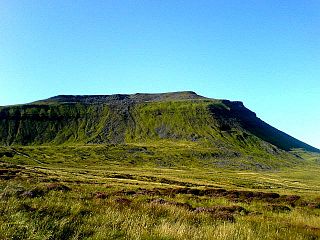
Wild Boar Fell is a mountain in the Yorkshire Dales National Park, on the eastern edge of Cumbria, England. At 2,323 feet (708 m), it is either the 4th-highest fell in the Yorkshire Dales or the 5th, depending on whether nearby High Seat (2,326 ft) is counted or not.

The A686 is a road in Northern England. It runs from Penrith in Cumbria to Haydon Bridge in Northumberland. AA Magazine named the A686 as one of their "Ten Great Drives" owing to the dramatic scenery of the North Pennines hills encountered along its route. Travel journalist Phil Llewellin said:
England’s great wilderness sprawls across the northern Pennines, where the mountains have fascinating names such as Fiend’s Fell and Wildboar Fell. Penrith merits a visit after leaving the M6, and memories of the motorway fade as the A686 crosses the River Eden valley. The mood changes dramatically in Melmerby, where the road starts its long climb to the cafe at Hartside, 1,900 feet (580 m) above sea level, with stunning views across the Solway Firth and Scotland. The road leads to Alston, which claims to be England’s highest market town, a charming little place with cobbled streets and quaint buildings. The A686 beyond Alston crosses another breathtaking expanse of windswept upland before running down to the River Allen's beautiful wooded gorge.

The mountains and hills of England comprise very different kinds of terrain, from a mountain range which reaches almost 1,000 metres high, to several smaller areas of lower mountains, foothills and sea cliffs. Most of the major upland areas have been designated as Areas of Outstanding Natural Beauty (AONB) or national parks. The highest and most extensive areas are in the north and west, while the midlands, south-east and east of the country tend to be low-lying.

Murton is a small village and civil parish in the Eden District of Cumbria, England. The parish had a population of 330 in 2001, rising to 360 at the 2011 Census. Settlements within the parish include the villages of Hilton, Langton, Brackenber and various small farms, houses and cottages. The town of Appleby-in-Westmorland is to the south-west.
A National Character Area (NCA) is a natural subdivision of England based on a combination of landscape, biodiversity, geodiversity and economic activity. There are 159 National Character Areas and they follow natural, rather than administrative, boundaries. They are defined by Natural England, the UK government's advisors on the natural environment.

