Knott, Caldbeck

Last updated

Knott
Knott from Lingy Hut.jpg
Knott from Lingy Hut
Highest point
Elevation 710 m (2,330 ft)
Prominence 242 m (794 ft)
Parent peak Skiddaw
Listing Marilyn, Hewitt, Wainwright, Nuttall
Coordinates 54°41′10″N3°05′37″W / 54.68621°N 3.09354°W / 54.68621; -3.09354
Geography
Lake District National Park UK relief location map.png
Red triangle with thick white border.svg
Knott
Location in Lake District, UK
Location Cumbria, England
Parent range Lake District, Northern Fells
OS grid NY296329
Topo map OS Landrangers 89, 90

Knott is a mountain in the northern part of the English Lake District. It is the highest point of the Back o'Skiddaw region, an area of wild and unfrequented moorland to the north of Skiddaw and Blencathra. Other tops in this region include High Pike, Carrock Fell and Great Calva. The fell's slopes are mostly smooth, gentle, and covered in grass, with a few deep ravines. It stands a long way from a road and requires a long walk across the moor top get to it; this, as well as the fact that it is hidden from the rest of the Lake District by the two aforementioned giants, make it one of the most unfrequented tops in the Lakes. When it is climbed it is most often from Mungrisdale or from the north via Great Sca Fell. The word Knott is of Cumbric origin, and means simply "hill".

Contents

Topography

Skiddaw and Blencathra are the best known of the Northern Fells, fronting the range as they loom above Keswick and the road to Penrith. Behind this wall is a further group of fells, commonly referred to as Back o' Skiddaw. [1] [2] Knott stands at the centre of this group, in addition to being the highest point.

The Back o'Skiddaw group is separated from Blencathra and the Skiddaw massif by Skiddaw Forest. It is not a woodland area other than the windbreak of Skiddaw House but is a former royal forest (an area once set aside for hunting) and is today a marshy upland area at around 1,300 feet (400 m) surrounded on all sides by higher fells. Three major streams flow from Skiddaw Forest, dividing the Northern Fells into three sectors. Dash Beck runs north-west, the River Caldew north-east and the River Glenderaterra south, between Skiddaw and Blencathra.

Knott itself is a long whale-backed ridge running for three miles (five kilometres) in an east–west direction. With the exception of the extreme east and west, the fell has broad and gentle contours clad primarily in grass. Many of the streams draining it have cut deeply into Knott's flanks, exposing yellow and red soils which are visible in distant views.

sketch map of Knott Knott sketch map.JPG
sketch map of Knott

The western end of the fell is Burn Tod, which descends roughly between Burntod and Hause Gills, both tributaries of Dash Beck. To the north is a parallel but shorter shoulder, Frozen Fell, and these two spurs are the only part of the fell which drain westward to the River Derwent.

From the south of the summit a ridge descends across a narrow col to the neighbouring fell of Great Calva. A further spur on this flank, across to the east, is named Snab. Wiley Gill and Burdell Gill fall on this side to the River Caldew and, ultimately, the Eden at Carlisle.

The eastern terminus of the summit ridge is Coomb Height. At the base of the slope, amid rough ground, are the remains of Carrock Fell Mine. Coombe Height is bordered by Wet Swine Gill and Grainsgill Beck, further tributaries of the Caldew.

Two connecting ridges run north from Knott, separated by the deep ravines of Roughton Gill. The western arms drops across an area of bog and with little reascent arrives at the summit of Great Sca Fell. The eastern branch crosses Miller Moss and then runs at high level for two miles (three kilometres) to High Pike, first passing the subsidiary tops of Great Lingy Hill and Harestones.

Miller Moss

In August 2018 it was reported that Miller Moss, also known as Little Lingy Hill, had been re-surveyed and measured as 610.1 metres (2,002 ft) with a prominence of 19.7 metres (65 ft), enabling it to be classed as a mountain and included in the list of Nuttalls. [3] [4] [5] [6]

Summit

Wainwright noted of the summit that "If the party consists of more than one person and if, further, a bat, ball and wickets can be found in the depths of somebody's rucksack, a cricket match can be played on turf many a county ground might covet." [1] Amidst the grass a cairn has been built. Further such markers adorn the tops of Coomb Height, Burn Tod and Snab, but the ridge top is otherwise featureless and the paths faint and intermittent.

The view southward is constrained by Blencathra and Skiddaw, neither displaying their best side, but between the two is a narrow slice of central Lakeland. This includes a section of distant Thirlmere along with the Scafells. To the north are the Solway Firth and the hills of south west Scotland, but there is little interest to the foreground. [1]

Computer-generated summit panorama

Mining

Although the main part of Carrock Fell Mine is beneath Carrock Fell, there are some workings to the south of Grainsgill Beck at the base of Coomb Height. A trench runs northward down the slope to the beck, containing a number of shafts and levels. These surface workings follow the line of the Harding vein, the most productive part of the mine. Carrock Fell Mine was the only British tungsten mine outside Cornwall and was operated at various times between 1850 and 1982 when the price of tungsten was sufficient. Although reserves of wolframite and other tungsten ores are believed to remain, the Harding vein beneath Knott has long been worked out and the levels were used for dumping sludge from ore processing operations. [7]

A small operation on the southern flank of Knott was Little Wiley Gill Mine. A 40-yard level was driven here, but no other information survives. [7]

Ascents

From Orthwaite to the north-west a track can be followed to the source of Hause Gill and the col between Knott and Great Calva. Alternatively a start can be made at Longlands, crossing the intervening ridge between Meal Fell and Great Cockup and then following a path up between Burn Tod and Frozen Fell.

Fell Side provides access from the north, along the old mine track beside Roughten Gill. Once the mine is reached a pathless climb can be made to the summit.

The access road to Carrock Fell Mine can be used to lead onto Coomb Height for an ascent from Mosedale. Wainwright gave dire warnings regarding the mine workings on this route. [1]

Related Research Articles

<span class="mw-page-title-main">Skiddaw</span> Mountain in the Lake District, England

Skiddaw is a mountain in the Lake District National Park in England. Its 931-metre (3,054 ft) summit is the sixth-highest in England. It lies just north of the town of Keswick, Cumbria, and dominates the skyline in this part of the northern lakes. It is the simplest of the Lake District mountains of this height to ascend and, as such, many walking guides recommend it to the occasional walker wishing to climb a mountain. This is the first summit of the fell running challenge known as the Bob Graham Round when undertaken in a clockwise direction.

<span class="mw-page-title-main">Blencathra</span> Hill in the Lake District, England

Blencathra, also known as Saddleback, is one of the most northerly hills in the English Lake District. It has six separate fell tops, of which the highest is the Hallsfell Top at 2,848 feet.

<span class="mw-page-title-main">Dale Head</span> Mountain in the Lake District, England

Dale Head is a fell in the north-western sector of the Lake District, in northern England. It is 753 metres or 2,470 foot above sea level and stands immediately north of Honister Pass, the road between Borrowdale and Buttermere.

<span class="mw-page-title-main">Clough Head</span> Mountain in the English Lake District, Cumbria, England

Clough Head is a fell, or hill, in the English Lake District. It marks the northern end of the main ridge of the Helvellyn range and is often walked as part of the ridge walk. The fell stands south of the village of Threlkeld and the A66 road, and it forms the steep eastern side of the tranquil valley of St John's in the Vale.

<span class="mw-page-title-main">Blake Fell</span>

Blake Fell is a hill in the Western part of the English Lake District. It is the highest point of the Loweswater Fells, an area of low grassy hills with steep sides overlooking the lake of Loweswater. The fell also overlooks the village of Loweswater, from which it can be climbed. An alternative route is from the Cogra Moss reservoir on its western slopes. Because the Loweswater Fells are a separate geographical unit, Blake Fell is a Marilyn. It is located in the Parish of Lamplugh.

<span class="mw-page-title-main">Mellbreak</span>

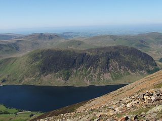
Mellbreak is a hill in the Western part of the English Lake District. Despite being surrounded on all sides by higher fells, it stands in isolation. It is surrounded on three sides by a "moat" of deep marshy land, and on the east side by the lake of Crummock Water. The fell forms a partnership with the lake, running parallel to it, falling sheer into it, and regularly providing the backdrop for pictures of it.

<span class="mw-page-title-main">Mungrisdale Common</span> Mountain in the Lake District, England

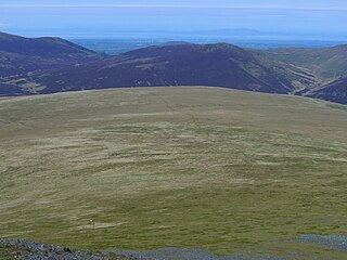
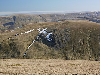
Mungrisdale Common, pronounced mun-grize-dl, with emphasis on grize, is a fell in the English Lake District. Although Alfred Wainwright listed it as one of the 214 featured hills in his influential Pictorial Guide to the Lakeland Fells it was his least favourite. He commented that it "has no more pretension to elegance than a pudding that has been sat on". There is some speculation that Wainwright included the fell in his guide simply as a way to fill space, but that has never been proven. Mungrisdale Common is oddly named, as it is a number of miles from the village of Mungrisdale, which lies in a different river catchment.

<span class="mw-page-title-main">Latrigg</span> Mountain in United Kingdom

Latrigg is one of the lowest fells in the Lake District in North West England, but is a popular climb due to its convenient location overlooking the town of Keswick and the beautiful views down the valley of Borrowdale from the summit. It is the least mountainous of the Skiddaw fells, the summit being almost entirely devoid of rock. The slopes of Latrigg are partially wooded, and logging work is currently being undertaken. One lone tree just south of the summit is prominently viewed in silhouette when approaching Keswick from the west along the A66. It also has petrified trees on top.

<span class="mw-page-title-main">Outerside</span> Fell in the Lake District, Cumbria, England

Outerside is a fell in the Lake District in Cumbria, England. It is located 6 kilometres west of Keswick in the north western part of the national park and is a smaller member of the Coledale group of fells with a height of 568 metres. The fell is part of a ridge on the southern side of Coledale which descends from the higher fell of Scar Crags and continues over the neighbouring smaller fell of Barrow before reaching the valley at the village of Braithwaite.

<span class="mw-page-title-main">Carrock Fell</span> Mountain in the Lake District, England

Carrock Fell is a fell in the English Lake District, situated in the northern region of the national park, 8 miles north-east of Keswick.

<span class="mw-page-title-main">High Pike</span> Mountain in England

High Pike is a fell in the northern part of the English Lake District, it is located 4+12 kilometres south of Caldbeck. It has a height of 658 metres (2,159 ft) and is the most northerly of the Lakeland fells over 2000 feet. It is a large fell with its northern slopes falling away towards the lower ground between Caldbeck and Carlisle. Like the neighbouring Carrock Fell it has been extensively mined and the wealth created by the abundant variety of minerals on High Pike led to the saying "Caldbeck fells are worth all England else". This fell should not be confused with another Lake District High Pike situated in Scandale near Ambleside.

<span class="mw-page-title-main">Great Sca Fell</span> Fell in the Lake District, England, UK

Great Sca Fell is a fell in the English Lake District, seven kilometres southwest of the village of Caldbeck. It is the highest of the four Uldale Fells, the other three being Longlands Fell, Meal Fell and Great Cockup. It is a Wainwright, and the lowest of the lakeland ‘Sca fells’, the other two being Scafell and Scafell Pike.

<span class="mw-page-title-main">Great Borne</span> Fell in the Lake District, Cumbria, England

Great Borne is a fell in the English Lake District with a height of 616 m (2,021 ft). It is a rather secluded hill situated at the western end of the long ridge which divides the Ennerdale and Buttermere valleys.

<span class="mw-page-title-main">Hart Side</span>

Hart Side is a subsidiary top on one of the east ridges of Stybarrow Dodd, which is a mountain in the English Lake District, west of Ullswater on the main Helvellyn ridge in the Eastern Fells. With a height of 2,480 feet (760 m) Hart Side rises above the col separating it from Green Side by 75 feet (23 m).

<span class="mw-page-title-main">Fellbarrow</span>

Fellbarrow is a low hill in the north west of the English Lake District. It is not far from the town of Cockermouth, near to Loweswater and can most easily be climbed from Low Lorton or Thackthwaite. From the summit there are views across the Lorton valley to Grasmoor and Whiteside.

<span class="mw-page-title-main">Great Calva</span> Mountain in the Lake District, England

Great Calva is a fell in the Lake District, England. It is in the Northern Fells, lying roughly at the centre of this region of high ground. As a result, it is distant from roads and quite remote by Lakeland standards. Great Calva stands at the head of a major geological fault running through the centre of the Lake District, and so from the summit it is possible to see all the way south over Thirlmere. The subsidiary summit of Little Calva lies to the west.

<span class="mw-page-title-main">Bannerdale Crags</span> Mountain in the Lake District, England

Bannerdale Crags is a fell in the English Lake District. It stands between Blencathra and Bowscale Fell in the Northern Fells.

<span class="mw-page-title-main">Bowscale Fell</span> Mountain in the Lake District, England

Bowscale Fell is a hill in the English Lake District. It rises above the village of Mungrisdale in the Northern Fells. Bowscale Fell stands at the extreme north east the Blencathra group, connected to this higher fell by the intervening Bannerdale Crags. In common with many fells the western slopes are smooth and convex while the eastern side exhibits crags.

<span class="mw-page-title-main">Lonscale Fell</span> Mountain in the Lake District, England

Lonscale Fell is a hill in the English Lake District. Its pointed second top is instantly recognisable, standing at the eastern end of the Skiddaw massif. The fell is easily climbed from Keswick or from Skiddaw House to the north. Although now primarily a sheep pasture, it once saw considerable mining activity beneath the long eastern wall of crag.

<span class="mw-page-title-main">Northern Fells</span>

The Northern Fells are a part of the Cumbrian Mountains in the Lake District of England. Including Skiddaw, they occupy a wide area to the north of Keswick. Smooth, sweeping slopes predominate, with a minimum of tarns or crags. Blencathra in the south-east of the group is the principal exception to this trend.

References

  1. 1 2 3 4 Wainwright, Alfred: A Pictorial Guide to the Lakeland Fells,Book 5 The Northern Fells: ISBN   0-7112-2458-7
  2. Birkett, Bill: Complete Lakeland Fells: Collins Willow (1994): ISBN   0-00-218406-0
  3. "Lake District hill Miller Moss reclassified as a mountain". BBC News. 10 August 2018. Retrieved 10 August 2018.
  4. Barnard, John; Jackson, Graham; Bloormer, Jim (9 August 2018). "England has a new mountain: Miller Moss. Now go find it". Grough. Retrieved 10 August 2018.
  5. "Miller Moss". WalkLakes. Retrieved 10 August 2018.
  6. Low, Valentine (10 August 2018). "Mapmakers peaked too soon: Lake District hill Miller Moss is really a mountain". The Times. Retrieved 10 August 2018.
  7. 1 2 Adams, John: Mines of the Lake District Fells: Dalesman (1995) ISBN   0-85206-931-6

See also