Mungrisdale Common

Last updated

Mungrisdale Common
Mungrisedale Common from Atkinson Pike, Blencathra.jpg
Seen from Atkinson Pike on Blencathra, 1.5 km to the SE with Great Calva in the background.
Highest point
Elevation 633 m (2,077 ft)
Prominence c. 2 m (6 ft)
Parent peak Atkinson Pike
Listing Wainwright
Coordinates 54°39′12″N3°04′13″W / 54.65343°N 3.07014°W / 54.65343; -3.07014
Geography
Lake District National Park UK relief location map.png
Red triangle with thick white border.svg
Mungrisdale Common
Location in Lake District, UK
Location Cumbria, England
Parent range Lake District, Northern Fells
OS grid NY312292
Topo map OS Landranger 90, Explorer OL4, OL5
sketch map of Mungrisdale Common Mungrisdale sketch map.JPG
sketch map of Mungrisdale Common

Mungrisdale Common, pronounced mun-grize-dl, with emphasis on grize, is a fell in the English Lake District. Although Alfred Wainwright listed it as one of the 214 featured hills in his influential Pictorial Guide to the Lakeland Fells it was his least favourite. He commented that it "has no more pretension to elegance than a pudding that has been sat on". [1] There is some speculation that Wainwright included the fell in his guide simply as a way to fill space, but that has never been proven. Mungrisdale Common is oddly named, as it is a number of miles from the village of Mungrisdale, which lies in a different river catchment.

Contents

Topography

Mungrisdale Common lies north of Blencathra of which it is an outlier. Gently graded grassy slopes fall from Atkinson Pike, Blencathra's northern summit. Upon meeting the head of Blackhazel Beck, the shoulder divides in two, the northeastern arm connecting to Bannerdale Crags and the north western branch continuing to descend to Mungrisdale Common. Beyond an almost imperceptible depression the re-ascent is only 6 ft (2 m).

After the brief plateau of the summit the descent continues westward toward Skiddaw Forest. Confusingly, the forest contains no trees other than the windbreak of Skiddaw House, but it is a marshy upland area, at around 400 m (1,300 ft), surrounded on all sides by higher fells. Three streams flow from Skiddaw Forest, dividing the Northern Fells into three sectors. Dash Beck runs north-west, the River Caldew north east and the Glenderaterra Beck south. The three ranges of the Northern Fells are the Skiddaw massif to the southwest, the Blencathra group including Mungrisdale Common to the south east and the area colloquially known as 'Back o'Skiddaw' [1] to the north. Skiddaw House, the lone building in the forest, has variously seen service as a shepherds' bothy and a Youth Hostel.

The Glenderaterra Beck lies to the west of Mungrisdale Common and its tributary, Roughten Gill, forms the southern boundary. A further feeder on this flank is Sinen Gill, whose waterfall is one of the fell's most notable features. [1] The River Caldew lies to the north, across which is Great Calva, most southerly of the Back o'Skiddaw fells. Despite its uninspiring appearance Mungrisdale Common does therefore stand on the important Eden-Derwent watershed, though it is not well defined at this point. Water from the southern flanks reach the sea at Workington while rain falling on the northern side heads for the Solway Firth via Carlisle. The watershed continues across Skiddaw Forest between the headwaters of the Caldew and Glenderaterra, linking onward to Lonscale Fell in the Skiddaw range.

Mungrisdale Common carries a very small cairn at the approximate summit, constructed only after Wainwright first encouraged climbing of the fell by including it in his 1962 guidebook. Two more prominent ancient cairns also grace the fell, one to the west of the summit and the other on a tongue of ground between Sinen Gill and Roughten Gill. A small stone pillar (marked 'stake' on OS maps) stands on the watershed at the head of Glenderaterra Beck and a further prominent Cloven Stone marks its continuation higher up the slope. Both have served as boundary stones. [1]

Geology

In common with much of the Northern Fells, the Kirk Stile Formation of the Skiddaw Group predominates. It is composed of laminated mudstone and siltstone with greywacke sandstone and is of Ordovician age. Unusually however, it is overlain by considerable beds of peat in the vicinity of Mungrisdale Common. [2]

The Glenderaterra valley was the scene of some mining activity in the 19th century. The northern workings were first named Glenderaterra Mine and later Brundholme Mine. They were driven primarily for lead but also copper ore and baryte. The returns were never economic, which led to the mine being abandoned in 1920. A little to the south was Blencathra Mine, which was worked unsuccessfully until about 1880. [3]

Summit

Wainwright's displeasure was not restricted to Mungrisdale Common's profile: he also remarked: "Any one of a thousand tufts of tough bent and cotton-grass might lay claim to crowning the highest point… A thousand tufts, yet not one can be comfortably reclined upon, this being a summit that holds indefinitely all the water that falls upon it." [1]

The view includes a striking window to the southwest between Lonscale Fell and Blencathra, revealing unexpectedly a run of high fells from Pillar to Crinkle Crags. Elsewhere, the view is of the nearby fells surrounding Skiddaw Forest. [1]

Ascents

"For people who won't be told" [1] Wainwright suggested ascents from Keswick or Threlkeld via the Glenderaterra valley. An alternative would be from Scales or Mungrisdale via the Glenderamackin col. Most ascents are likely to be as part of a climb of Blencathra, the intervening ground being gentle of gradient.

Trivia

Apart from the sub 1,000 ft Castle Crag, Mungrisdale Common is the only Wainwright not to feature in Bill Birkett's Complete Lakeland Fells. [4]

Related Research Articles

<span class="mw-page-title-main">Skiddaw</span> Mountain in the Lake District, England

Skiddaw is a mountain in the Lake District National Park in England. Its 931-metre (3,054 ft) summit is the sixth-highest in England. It lies just north of the town of Keswick, Cumbria, and dominates the skyline in this part of the northern lakes. It is the simplest of the Lake District mountains of this height to ascend and, as such, many walking guides recommend it to the occasional walker wishing to climb a mountain. This is the first summit of the fell running challenge known as the Bob Graham Round when undertaken in a clockwise direction.

<span class="mw-page-title-main">Blencathra</span> Hill in the Lake District, England

Blencathra, also known as Saddleback, is one of the most northerly hills in the English Lake District. It has six separate fell tops, of which the highest is the Hallsfell Top at 2,848 feet.

<span class="mw-page-title-main">Skiddaw Little Man</span> Fell in the Lake District, Cumbria, England

Skiddaw Little Man also called Little Man is a fell in the English Lake District, it is situated four kilometres north of the town of Keswick and reaches a height of 865 metres (2,838 ft).

<span class="mw-page-title-main">Dale Head</span> Mountain in the Lake District, England

Dale Head is a fell in the north-western sector of the Lake District, in northern England. It is 753 metres or 2,470 foot above sea level and stands immediately north of Honister Pass, the road between Borrowdale and Buttermere.

<span class="mw-page-title-main">Grasmoor</span> Mountain in the English Lake District, Cumbria, England

Grasmoor is a mountain in the north-western part of the Lake District, northern England. It is the highest peak in a group of hills between the villages of Lorton, Braithwaite and Buttermere, and overlooks Crummock Water.

<span class="mw-page-title-main">Causey Pike</span> Mountain in the English Lake District, Cumbria, England

Causey Pike is a fell in the English Lake District. It is situated in the Newlands Valley, 5 kilometres south-west of the town of Keswick. Even though it has a modest height of 637 metres (2,090 ft) it is one of the most distinctive fells when viewed from the Derwent Water and Keswick area due to its distinguishing summit "knobble" which catches the eye. The fell is one of 214 fells described by Alfred Wainwright in his series of Pictorial Guides to the Lakeland Fells: Causey Pike features in Book Six, The North Western Fells.

<span class="mw-page-title-main">Knott, Caldbeck</span> Mountain in the Lake District, England

Knott is a mountain in the northern part of the English Lake District. It is the highest point of the Back o'Skiddaw region, an area of wild and unfrequented moorland to the north of Skiddaw and Blencathra. Other tops in this region include High Pike, Carrock Fell and Great Calva. The fell's slopes are mostly smooth, gentle, and covered in grass, with a few deep ravines. It stands a long way from a road and requires a long walk across the moor top get to it; this, as well as the fact that it is hidden from the rest of the Lake District by the two aforementioned giants, make it one of the most unfrequented tops in the Lakes. When it is climbed it is most often from Mungrisdale or from the north via Great Sca Fell. The word Knott is of Cumbric origin, and means simply "hill".

High Rigg is a small fell located in the English Lake District, approximately three miles southeast of the town of Keswick. It occupies an unusual position, surrounded on all sides by higher fells but not connected by any obvious ridge. This separation from its fellows ensures that it is a Marilyn.

<span class="mw-page-title-main">Latrigg</span> Mountain in United Kingdom

Latrigg is one of the lowest fells in the Lake District in North West England, but is a popular climb due to its convenient location overlooking the town of Keswick and the beautiful views down the valley of Borrowdale from the summit. It is the least mountainous of the Skiddaw fells, the summit being almost entirely devoid of rock. The slopes of Latrigg are partially wooded, and logging work is currently being undertaken. One lone tree just south of the summit is prominently viewed in silhouette when approaching Keswick from the west along the A66. It also has petrified trees on top.

<span class="mw-page-title-main">Outerside</span> Fell in the Lake District, Cumbria, England

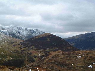
Outerside is a fell in the Lake District in Cumbria, England. It is located 6 kilometres west of Keswick in the north western part of the national park and is a smaller member of the Coledale group of fells with a height of 568 metres. The fell is part of a ridge on the southern side of Coledale which descends from the higher fell of Scar Crags and continues over the neighbouring smaller fell of Barrow before reaching the valley at the village of Braithwaite.

<span class="mw-page-title-main">Glenderaterra Beck</span> River in Cumbria, England

Glenderaterra Beck is a watercourse in the county of Cumbria, England. The length of the Glenderaterra, and its major tributary Whit Beck is 4.8 miles (7.8 km), which have a total catchment area of 11.8 square kilometres (4.6 sq mi).

<span class="mw-page-title-main">Bakestall</span> Mountain in the Lake District, England

Bakestall is a fell in the English Lake District, it is situated seven kilometres north of Keswick in the quieter, even secluded northern sector of the national park known as ‘Back o’ Skiddaw’.

<span class="mw-page-title-main">Great Calva</span> Mountain in the Lake District, England

Great Calva is a fell in the Lake District, England. It is in the Northern Fells, lying roughly at the centre of this region of high ground. As a result, it is distant from roads and quite remote by Lakeland standards. Great Calva stands at the head of a major geological fault running through the centre of the Lake District, and so from the summit it is possible to see all the way south over Thirlmere. The subsidiary summit of Little Calva lies to the west.

<span class="mw-page-title-main">Starling Dodd</span>

Starling Dodd is a fell in the western part of the English Lake District, located between the valleys of Ennerdale and Buttermere, on the ridge between Great Borne to its west and Red Pike to its east. Not visible from Buttermere and rounded in profile, Starling Dodd is a relatively unfrequented top.

<span class="mw-page-title-main">Crag Fell</span> Fell in the Lake District, England

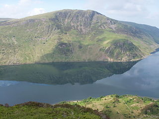
Crag Fell is a hill in the English Lake District. It is part of the Lank Rigg group, standing above Ennerdale Water in the Western Fells. The craggy northern face above the lake gives the fell its name, prominent in views from the car park at Bowness Knott. Ascents are commonly made from the foot of Ennerdale Water.
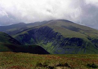
<span class="mw-page-title-main">Bannerdale Crags</span> Mountain in the Lake District, England

Bannerdale Crags is a fell in the English Lake District. It stands between Blencathra and Bowscale Fell in the Northern Fells.

<span class="mw-page-title-main">Bowscale Fell</span> Mountain in the Lake District, England

Bowscale Fell is a hill in the English Lake District. It rises above the village of Mungrisdale in the Northern Fells. Bowscale Fell stands at the extreme north east the Blencathra group, connected to this higher fell by the intervening Bannerdale Crags. In common with many fells the western slopes are smooth and convex while the eastern side exhibits crags.

<span class="mw-page-title-main">Lonscale Fell</span> Mountain in the Lake District, England

Lonscale Fell is a hill in the English Lake District. Its pointed second top is instantly recognisable, standing at the eastern end of the Skiddaw massif. The fell is easily climbed from Keswick or from Skiddaw House to the north. Although now primarily a sheep pasture, it once saw considerable mining activity beneath the long eastern wall of crag.

<span class="mw-page-title-main">Souther Fell</span> Mountain in the Lake District, England

Souther Fell is a fell in the English Lake District. It stands to the south of Mungrisdale village in the Northern Fells. It is most famous for the appearance of a "spectral army", said to have been seen marching along its crest on Midsummer's Day, 1745. No such force was in the District at the time.

<span class="mw-page-title-main">Northern Fells</span>

The Northern Fells are a part of the Cumbrian Mountains in the Lake District of England. Including Skiddaw, they occupy a wide area to the north of Keswick. Smooth, sweeping slopes predominate, with a minimum of tarns or crags. Blencathra in the south-east of the group is the principal exception to this trend.

References

  1. 1 2 3 4 5 6 7 Wainwright, Alfred: A Pictorial Guide to the Lakeland Fells,Book 5 The Northern Fells: ISBN   0-7112-2458-7
  2. British Geological Survey: 1:50,000 series maps, England & Wales Sheet 29: BGS (1999)
  3. Adams, John: Mines of the Lake District Fells: Dalesman (1995) ISBN   0-85206-931-6
  4. Birkett, Bill: Complete Lakeland Fells: Collins Willow (1994): ISBN   0-00-218406-0