
Castle Morpeth was a local government district and borough in Northumberland, England. Its administrative centre was the town of Morpeth.

Kielder Forest is a large forestry plantation in Northumberland, England, surrounding Kielder village and the Kielder Water reservoir. It is the largest man-made woodland in England with three-quarters of its 250 square miles (650 km2) covered by forest. The majority of the forest lies within Kielder Water and Forest Park, with the southern tip known as Wark Forest lying within Northumberland National Park. The forest is next to the England - Scotland border.

Whitwell is a village in Derbyshire, England. The population of the civil parish taken at the 2011 Census was 3,900.

Hutton Roof Crags is a hill in south-eastern Cumbria in north-west England, located near to the village of Hutton Roof. It has extensive areas of limestone pavement as well as grassland and woodland. The hill forms the Hutton Roof Crags Site of Special Scientific Interest and is part of the Morecambe Bay Pavements Special Area of Conservation. A significant proportion of the UK's 20 km2 (7.7 sq mi) of limestone pavement is to be found on Hutton Roof Crags and the neighbouring Farleton Knott.

Hadrian's Wall Path is a long-distance footpath in the north of England, which became the 15th National Trail in 2003. It runs for 84 miles (135 km), from Wallsend on the east coast of England to Bowness-on-Solway on the west coast. For most of its length it is close to the remains of Hadrian's Wall, the defensive wall built by the Romans on the northern border of their empire. This is now recognised as part of the "Frontiers of the Roman Empire" World Heritage Site.

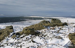
Tosson Hill is the highest hill in the Simonside Hills to the south of Rothbury in Northumberland, England. The summit lies about 2 kilometres (1.2 mi) west of Simonside, the best-known summit of the Simonside Hills.

Housedon Hill is a hill on the northwestern edge of the Cheviot Hills in Northumberland, England. It is the northernmost Marilyn in England, the summit lying only about 4 miles (7 km) from the Scottish border, which runs to the north and west.

Grisedale Pike is a fell in the Lake District, Cumbria, England, situated 4+1⁄2 miles west of the town of Keswick in the north-western sector of the national park. At a height of 791 metres it is the 40th-highest Wainwright in the Lake District; it also qualifies as a Hewitt, Marilyn and Nuttall. Grisedale Pike presents a striking appearance when viewed from the east, particularly from the vicinity of Keswick. It possesses two subsidiary summits: one unnamed ; the other Hobcarton End.
Sighty Crag is a hill in the southern part of the Kielder Forest region in northern England, a region which also includes its fellow Marilyns of Peel Fell and Larriston Fells. It is separated from its higher and more shapely counterpart, Peel Fell, by the low valley in which sits the village of Kielder.

Wharncliffe Crags is a gritstone escarpment or edge situated approximately 6 miles (10 km) north-west of the city of Sheffield in South Yorkshire, England. It is a geological Site of Special Scientific Interest.

Yester Parish Church is a church of the Church of Scotland in the village of Gifford, East Lothian, Scotland. The village forms part of Yester, Bolton and Saltoun parish, and is a linked charge with Humbie Parish Church.

Rothley is a small settlement and civil parish in Northumberland, England about 2 miles (3 km) north east of Cambo and about 6 miles (10 km) west of Morpeth.

East Woodburn is a village located in Northumberland, England. Located on the A68 road just south of Darney Crag, it was created in conjunction with the Darney quarry, which provided its distinct fine to medium grained pale gold through, light buff to almost blond in colour sandstone.
Forestry England is a division of the Forestry Commission, responsible for managing and promoting publicly owned forests in England. It was formed as Forest Enterprise in 1996, before devolving to Forest Enterprise England on 31 March 2003 and then being rebranded to Forestry England on 1 April 2019.

Shabbington Woods Complex is a 305.6-hectare (755-acre) biological Site of Special Scientific Interest ( between Horton-cum-Studley and Worminghall in Buckinghamshire. It comprises Shabbington Wood, Bernwood Forest, Hell Coppice, Oakley Wood and York's Wood. Shabbington Wood is owned by the Forestry Commission, and a small area of 7.5 hectares called Bernwood Meadows is managed by the Berkshire, Buckinghamshire and Oxfordshire Wildlife Trust.

Jenny's Lantern is an area of moorland in north Northumberland, England, taking its name from an 18th-century 'eye-catcher' folly sited towards the top of a small promontory hill above the River Aln. Situated on the southern slope of the Jenny's Lantern area is an Iron Age hillfort, overbuilt by and adjoined to a larger and very well preserved Romano-British stone-built settlement and field system. It partially collapsed during a storm in November 2021.
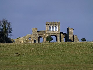
Ratcheugh Observatory is a late 18th-century folly on a prominent crag between Alnwick and Longhoughton in north Northumberland, England. Commissioned by Hugh Percy, 1st Duke of Northumberland, the castellated Observatory incorporates a viewing tower with prospects of Alnwick and its castle, and of the North Sea coast at Boulmer.

Harwood Forest is a 3,527 hectares conifer plantation located to the south of Rothbury in North Northumberland, England, and managed by Forestry England.
Thrunton Wood is an area of woodland and open moor in Northumberland. It is popular with walkers, mountain bikers and horse riders, and home to two waymarked walking trails. There is an Iron Age fort on Castle Hill, and Thrunton Wood is home to several caves, including Macartney's Cave, once home to a local monk, and Thomas Wedderburn's Hole, where a local highwayman reputedly once hid from the law.

