Seat Sandal

Last updated

Seat Sandal
Seat Sandal from Helm Crag.jpg
Seat Sandal (left) and Fairfield (right)
seen from Helm Crag 2 km to the SW.
Highest point
Elevation 736 m (2,415 ft)
Prominence c. 150 m
Parent peak Fairfield
Listing Hewitt, Marilyn, Nuttall, Wainwright
Coordinates 54°29′40″N3°00′57″W / 54.49456°N 3.01585°W / 54.49456; -3.01585
Geography
Lake District National Park UK relief location map.png
Red triangle with thick white border.svg
Seat Sandal
Location in Lake District, UK
Location Cumbria, England
Parent range Lake District, Eastern Fells
OS grid NY343115
Topo map OS Landranger 90 OS Explorer 5

Seat Sandal is a fell in the English Lake District, situated four kilometres (2+12 miles) north of the village of Grasmere from where it is very well seen. Nevertheless, it tends to be overshadowed by its more illustrious neighbours in the Eastern Fells, Helvellyn and Fairfield.

Contents

Name

The unusual name comes from the Old Norse language, " Sandulfr " being an Old Norse personal name. [1]

The name element ' Seat ' is from Old Norse ' sæter ' . [lower-alpha 1]

Toponym

Examples of place names with a similar etymology might include :

The remains of structures have been found on Seat Sandal that are assumed to have been summer shielings (high altitude dwellings ) where people stayed during the summer months in order to watch over the animals. [lower-alpha 4] [lower-alpha 5] [lower-alpha 6]

Both Seat Sandal and Seatoller (Seat..oller ) are positioned on historic routes that traverse across the heart of the Lake District, suggesting that these were important strategic places. [lower-alpha 7] [lower-alpha 8]

Topography

Looking down Grisedale to Ullswater in the far distance from Seat Sandal summit; St Sunday Crag is the fell on the right. Grisedale from Seat Sandal.jpg
Looking down Grisedale to Ullswater in the far distance from Seat Sandal summit; St Sunday Crag is the fell on the right.

The fell's western flanks above Dunmail Raise are grassy and smooth while its eastern slopes are steep and craggy as they fall away towards Grisedale Hause which at 537 m (1,762 ft) contains Lakeland's highest substantial tarn, Grisedale Tarn. The fell reaches a height of 736 m (2,415 ft) and just scrapes into the list of Marilyns by being given prominence of ‘around’ 150 metres from the higher fell of Fairfield. However, this must be regarded as a borderline case as there is no Ordnance Survey surveyed height for the top of Grisedale Hause. Alfred Wainwright gives it a height of 1,929 feet (588 metres) giving Seat Sandal a topographic prominence of only 148 metres (two metres short of Marilyn qualification).

Seat Sandal is distinctive in that its drainage reaches the sea at more widely spread points than any other Lakeland Fell, with Raise Beck going through Thirlmere and Derwent Water to reach the Irish Sea at Workington, Tongue Beck going through the lakes of Grasmere and Windermere to reach Morecambe Bay and Grisedale Beck draining into Ullswater and then to the sea at the Solway Firth. However, this is true only as a result of the diversion of Raise Beck north to feed Thirlmere Reservoir — before this (and still today when there is enough water in Raise Beck for it to flow both north and south), Dollywaggon Pike shared in this distinction — Birkside Gill feeding Thirlmere, Raise Beck feeding Grasmere, and Grisedale Beck feeding Ullswater. The fell's main topographic attraction is Gavel Crag on its eastern side, which is connected to the main body of the fell by a fine rock arête.

Dunmail Raise provides the topographical connection between the Eastern and Central Fells, Steel Fell rising on the other side of the pass.

Geology

A hill of andesite lava forms the summit, the rocks beneath being the dacitic lapilli-tuffs of the Lincomb Tarns Formation. [8]

Ascents

The fell can be ascended from Grasmere or Dunmail Raise although a start from Patterdale is quite feasible. The Grasmere or Patterdale starts use the old packhorse route that links the two places; this is now part of Wainwright's Coast to Coast Walk. When Grisedale Hause is reached it is a steep climb to the summit following a broken wall. The ascent from Dunmail Raise follows the bed of Raise Beck until it peters out at a height of 580 m (1,900 ft); it is then a walk south up easy slopes to reach the summit. There is also a direct ascent up the western slopes starting at Mill Bridge.

Summit

The view from the top is limited by the nearby Helvellyn and Fairfield ranges although there is a good view of Lakeland to the west; the Solway Firth and Criffel are seen on a good day as is Morecambe Bay to the south.

Related Research Articles

<span class="mw-page-title-main">Helvellyn</span> Mountain in the English Lake District

Helvellyn is a mountain in the English Lake District, the highest point of the Helvellyn range, a north–south line of mountains to the north of Ambleside, between the lakes of Thirlmere and Ullswater.

<span class="mw-page-title-main">Fairfield (Lake District)</span> Fell in the English Lake District

Fairfield is a fell in the English Lake District. It is the highest of a group of hills in the Eastern Fells, standing to the south of the Helvellyn range.

<span class="mw-page-title-main">Great End</span> Mountain in the Lake District, England

Great End is the most northerly mountain in the Scafell chain, in the English Lake District. From the south it is simply a lump continuing this chain. From the north, however, it appears as an immense mountain, with an imposing north face rising above Sprinkling Tarn (lake). This is a popular location for wild camping, and the north face attracts many climbers.

<span class="mw-page-title-main">Place Fell</span> Fell in the Lake District, Cumbria, England

Place Fell is a hill in the English Lake District. It stands at the corner of the upper and middle reaches of Ullswater, with steep western flanks overlooking the villages of Glenridding and Patterdale.

<span class="mw-page-title-main">High Raise (Langdale)</span> Mountain in the English Lake District, Cumbria, England

High Raise is a fell in the Central Fells of the English Lake District, not to be confused with another High Raise situated in the Far Eastern Fells. High Raise is one of the most spectacular mountains in the district; with a height of 762 metres (2,500 ft) it is the highest point in the central fells of Lakeland.

<span class="mw-page-title-main">Nethermost Pike</span> Fell in Cumbria, England

Nethermost Pike is a fell in Cumbria, England, and a part of the Lake District. At 891 metres (2,923 ft) it is the second highest Wainwright in the Helvellyn range, the highest of which is Helvellyn itself. It is located close to the southern end of the ridge, with Helvellyn to the north, and High Crag and Dollywaggon Pike to the south. Nethermost Pike, along with many of the Eastern Fells, lies between Thirlmere in the west and the Ullswater catchment in the east. The closest villages are Glenridding and Patterdale on the shores of Ullswater, over 8 kilometres (5 mi) away.

<span class="mw-page-title-main">Raise (Lake District)</span> Fell in the Lake District, Cumbria, England

Raise is a fell in the English Lake District. It stands on the main spine of the Helvellyn range in the Eastern Fells, between Thirlmere and Ullswater.

<span class="mw-page-title-main">St Sunday Crag</span>

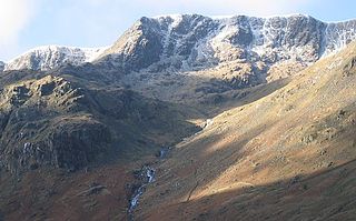
St Sunday Crag is a fell in the English Lake District, part of the Fairfield group in the Eastern Fells. It is a prominent feature in the Patterdale skyline, with a distinctive rounded shape. Indeed, it figures so finely in views from the upper reach of the lake that it is sometimes referred to as ‘the Ullswater Fell’.

<span class="mw-page-title-main">Dollywaggon Pike</span> Mountain in the English Lake District, Cumbria, England

Dollywaggon Pike is a fell in the English Lake District. It stands on the main spine of the Helvellyn range in the Eastern Fells, between Thirlmere and the Ullswater catchment.

The Helvellyn range is the name given to a part of the Eastern Fells in the English Lake District, "fell" being the local word for "hill". The name comes from Helvellyn, the highest summit of the group.

<span class="mw-page-title-main">Angletarn Pikes</span> Fell in the Lake District, Cumbria, England

Angletarn Pikes is a fell in the English Lake District near the village of Patterdale. Its most notable feature is Angle Tarn from which it derives its name.

<span class="mw-page-title-main">Glaramara</span> Mountain in the English Lake District, Cumbria, England

Glaramara is a fell in the English Lake District in Cumbria. It is a substantial fell that is part of a long ridge that stretches for over six kilometres from Stonethwaite in Borrowdale up to the important mountain pass of Esk Hause. The summit of Glaramara at 783 metres (2,569 ft) is the central point of this ridge, which separates the valleys of Langstrath and Grains Gill. However, the ridge has two additional fells, numerous subsidiary tops and several small tarns making its traverse an appealing and challenging walk.

Armboth Fell is a fell in the English Lake District, regarded by Alfred Wainwright as the centre of Lakeland. It is named for the former settlement of Armboth. The fell is a domed plateau, three-quarters of a mile across, jutting out to the east of the Derwentwater-Thirlmere watershed, in the Borough of Allerdale. The fell is wet underfoot, with large areas clad in heather. The eastern slopes above Thirlmere have been planted with conifers.

<span class="mw-page-title-main">Steel Fell</span>

Steel Fell is a fell in the English Lake District, lying between Thirlmere and Grasmere. It is triangular in plan, the ridges running north, west and south east. Steel Fell rises to the west of the Dunmail Pass road and can be climbed from the summit, or from Grasmere and Wythburn.

<span class="mw-page-title-main">Tarn Crag (Easedale)</span> Fell in the Lake District, Cumbria, England

Tarn Crag is a fell in the Central Fells of the English Lake District. Strictly the name refers only to the rock face looking down upon Easedale Tarn, but Alfred Wainwright applied it to the entire ridge lying between the Easedale and Far Easedale valleys in his Pictorial Guide to the Lakeland Fells

<span class="mw-page-title-main">Calf Crag</span> Fell in Cumbria, England

Calf Crag is a fell in the English Lake District, on the eastern side of the High Raise massif.

<span class="mw-page-title-main">Birkhouse Moor</span>

Birkhouse Moor is a fell in the English Lake District, an outlier of the Helvellyn range in the Eastern Fells. It is properly an eastern ridge of Helvellyn, but was treated as a separate fell by Alfred Wainwright in his Pictorial Guide to the Lakeland Fells. That convention is followed here.

<span class="mw-page-title-main">Eastern Fells</span>

The Eastern Fells are a group of hills in the English Lake District. Centred on Helvellyn they primarily comprise a north–south ridge running between Ullswater and Lakeland's Central Valley.

The Central Fells are a group of hills in the English Lake District. Reaching their highest point at High Raise, they occupy a broad area to the east of Borrowdale. The Central Fells are generally lower than the surrounding hills, the Lake District's dome-like structure having a slight dip in the middle. The range extends from the boggy ridge between Derwentwater and Thirlmere in the north, to the rock peaks of the Langdale Pikes in the south.

<span class="mw-page-title-main">Eadwig's Charter to Abingdon Abbey c.957</span>

In a charter of c.957 AD, King Eadwig granted twenty hides of land to Abingdon Abbey.

aet Hengestesige , and aet Seofecanwyrthe , and aet Wihtham

References

Notes

  1. Definition of Old Norse ' sæter '
    • " A mountain pasture, a shieling " . [2]
    • " Summer pasture " . [3]
    • " Upland summer pasture or farmstead " . [4]
  2. " Sandal " is an anglicisation of the Old Norse personal name " Sandulfr "
  3. Olaf Sandal  : The Viking ruler Olaf Sihtricson, King of Northumbria (r. 941 – 943 ), was also known as " Olaf Sandal " . [5]
  4. Summer shielings  : " ...historical sites ...Little Langdale ...Seat Sandal " . [6]
  5. Summer transhumance " We know from the evidence of Norse farming customs in north Scotland that Norse settlers in Britain continued the system of summer transhumance which was customary in their Scandinavian homeland. " [6]
  6. See Transhumance > Scandinavian peninsula
  7. Historic Routes  : The routes that the Scandinavian settlers might have used are mirrored by Wainwrights's Coast to Coast Walk from St Bees Head to Keld : [7]
  8. It would be expected that meat and perhaps dairy might have been traded at these locations.

Citations

  1. Nordic Names : Sandulfr
  2. Reaney 1969, p. 174.
  3. Rollinson 1981, p. 34.
  4. Gambles 1997, p. 4.
  5. Williams 2017, p. 290.
  6. 1 2 Gambles 1997, p. 154.
  7. OS Maps 2000, p. 1.
  8. British Geological Survey: 1:50,000 series maps, England & Wales Sheet 29: BGS (1999)

Sources

Maps

  • OS Maps (2000). Wainwrights's Coast to Coast Walk - St Bees Head to Keld. Ordnance Survey. ISBN   0-319-26090-9.

Books