Dollywaggon Pike

Last updated

Dollywaggon Pike
Dollywaggon Pike from Deepdale Hause.jpg
Dollywaggon Pike, seen from Deepdale Hause
Highest point
Elevation 858 m (2,815 ft)
Prominence 50 m (164 ft)
Parent peak Helvellyn
Listing Hewitt, Nuttall, Wainwright
Coordinates 54°30′29″N3°00′42″W / 54.50807°N 3.01156°W / 54.50807; -3.01156 Coordinates: 54°30′29″N3°00′42″W / 54.50807°N 3.01156°W / 54.50807; -3.01156
Geography
Lake District National Park UK relief location map.png
Red triangle with thick white border.svg
Dollywaggon Pike
Location relief map United Kingdom Allerdale.svg
Red triangle with thick white border.svg
Dollywaggon Pike
Location bordering Allerdale, Cumbria
Location relief map United Kingdom Eden.svg
Red triangle with thick white border.svg
Dollywaggon Pike
Location bordering Eden, Cumbria
Location Cumbria, England
Parent range Lake District, Eastern Fells
OS grid NY346130
Topo map OS Landranger 90, Explorer OL5

Dollywaggon Pike is a fell in the English Lake District. It stands on the main spine of the Helvellyn range in the Eastern Fells, between Thirlmere and the Ullswater catchment.

Contents

Name

The spelling ‘Dollywaggon’ is used on Ordnance Survey 1:25,000 maps but ‘Dollywagon’ on 1:50,000 maps. The Ordnance Survey gazetteer, nominally based on the 1:50,000 maps, lists only ‘Dollywaggon Pike’. As of 2005, the ‘Dollywagon’ spelling is slightly more common in online references. Alfred Wainwright used ‘Dollywaggon Pike’ in his Pictorial Guide , a position supported by other writers. [1] [2] One etymology for the word Dollywaggon gives an Old Norse source formed by the combination of dolgr (‘fiend’ or ‘giant’) and veginn (‘lifted’). [3]

Topography

Map showing Dollywaggon Pike and surrounding features from 1925. Dollywaggon Pike.jpg
Map showing Dollywaggon Pike and surrounding features from 1925.

The Helvellyn range runs broadly north–south for about 7 miles, remaining above 2,000 ft (600 m) throughout its length. Dollywaggon Pike is the southernmost fell of the ridge proper, with Nethermost Pike immediately to the north. There is a subsidiary top between Nethermost and Dollywaggon Pikes named High Crag (2,990 ft / 884 m). Due to the very limited depression between the two, most guidebooks follow Wainwright [4] in counting High Crag as a part of Nethermost Pike.[ citation needed ] To the south of Dollywaggon Pike is the complex depression containing Grisedale Tarn, with Seat Sandal and Fairfield rising beyond.

In common with much of the Helvellyn range there is a marked contrast between the western and eastern slopes of Dollywaggon Pike. In Wainwright’s words ‘To the west, uninteresting grass slopes descend to Dunmail Raise almost unrelieved by rock and scarred only by the wide stony track gouged across the breast of the fell by the boots of generations of pilgrims to Helvellyn. But the eastern side is a desolation of crag and boulder and scree.’ [4]

High Crag, often considered part of Nethermost Pike, seen from Dollywaggon Pike summit. High Crag from Dollywaggon Pike.jpg
High Crag, often considered part of Nethermost Pike, seen from Dollywaggon Pike summit.

The western flank is named Willie Wife Moor for reasons lost to antiquity. It is bounded by Birkside Gill to the north and Raise Beck to the south, Reggle Knott being the only area of rough ground. At the base of the slope Raise Beck flows north to Thirlmere, having been diverted as a part of the 1884 reservoir project. It previously turned south down the other side of Dunmail Raise pass to feed Grasmere. Before this diversion, Dollywaggon Pike was distinctive in that its drainage reached the sea at more widely spread points than any other Lakeland Fell, with Raise Beck going through Grasmere and Windermere to reach Morecambe Bay, Birkside Gill going through Thirlmere and Derwent Water to reach the Irish Sea at Workington and Grisedale Beck draining into Ullswater and then to the sea at the Solway Firth. This is still the case today when there is enough water in Raise Beck for it to flow both north and south, but normally Seat Sandal now has this distinction.

Birkside Gill contains the remains of a number of levels driven for copper between 1840 and 1866. [5]

On the east, the first impression is all of rock. The long strath of Grisedale runs north-eastward to Ullswater, cutting off a series of hanging valleys which fall from the Helvellyn range. To the north-east of Dollywaggon Pike, below the summit of High Crag, is Ruthwaite Cove, a corrie surrounded on three sides by crag. Ruthwaite Cove is now the site of Ruthwaite Lodge, a climbing hut. It was formerly the setting for more industrious activity, with the remains of several levels and some shallow open mineworking being visible near the Lodge. These excavations were made for lead-bearing galena, and are believed to have been worked in the sixteenth century. Further leases were taken out in 1784 and 1862, the last-known operation being in 1880. [5] To the east of Dollywaggon Pike is a second corrie, Cock Cove, with Falcon Crag and the deeply gullied Tarn Crag providing the impressive headwall.

Cock Cove seen from The Tongue on Dollywaggon Pike. Cock Cove.jpg
Cock Cove seen from The Tongue on Dollywaggon Pike.

Between the two coves, Dollywaggon Pike sends out a fine rocky ridge, The Tongue. This arête ascends by a series of rocky steps making straight for the summit. At the bottom of The Tongue is Spout Crag, standing above Grisedale Beck and forcing walkers to take a detour from the ridgeline.

North of Dollywaggon Pike the ridge narrows and then steps up over High Crag to the plateau top of Nethermost Pike. In the other direction the high ground curves south-east around Cock Cove before a long slope falls to Grisedale Tarn at around 1,770 ft (539 m). This sizeable tarn has a depth of around 110 ft (34 m) and holds brown trout, perch and eels. [6] The outflow is to Ullswater to the north east, picking up all of the rainfall from the eastern face of Dollywaggon Pike. To the west of the tarn is the unnamed col between Dollywaggon Pike and Seat Sandal and immediately to the south is Grisedale Hause, the depression between Seat Sandal and Fairfield. Thus Seat Sandal stands topographically on the ridge between the two higher fells, but so out on a limb that many walkers proceed directly from Dollywaggon Pike to Fairfield.

Geology

Geologically the summit of the fell forms part of the Deepdale Formation, (principally volcaniclastic sandstone) underlain by the dacitic lapilli-tuff of the Helvellyn Formation. [7]

Summit

The summit is a small grassy rise directly at the head of The Tongue. It carries a small cairn with a larger one a few yards to the west. The view is extensive with the eastern foreground particularly fine [1]

Ascents

The Tongue provides a fine route of ascent, though a long one, from Patterdale and the fell can also be reached from the Grasmere area via Grisedale Tarn. Ascents up the western slopes are unimpeded but uninteresting.

Related Research Articles

Helvellyn Mountain in the English Lake District

Helvellyn is a mountain in the English Lake District, the highest point of the Helvellyn range, a north–south line of mountains to the north of Ambleside, between the lakes of Thirlmere and Ullswater.

Fairfield (Lake District) Fell in the English Lake District

Fairfield is a fell in the English Lake District. It is the highest of a group of hills in the Eastern Fells, standing to the south of the Helvellyn range.

Catstye Cam is a fell in the English Lake District. It is an outlier of Helvellyn in the Eastern Fells.

Nethermost Pike Fell in Cumbria, England

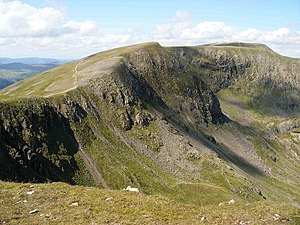
Nethermost Pike is a fell in Cumbria, England, and a part of the Lake District. At 891 metres (2,923 ft) it is the second highest Wainwright in the Helvellyn range, the highest of which is Helvellyn itself. It is located close to the southern end of the ridge, with Helvellyn to the north, and High Crag and Dollywaggon Pike to the south. Nethermost Pike, along with many of the Eastern Fells, lies between Thirlmere in the west and the Ullswater catchment in the east. The closest villages are Glenridding and Patterdale on the shores of Ullswater, over 8 kilometres (5 mi) away.

Raise (Lake District)

Raise is a fell in the English Lake District. It stands on the main spine of the Helvellyn range in the Eastern Fells, between Thirlmere and Ullswater.

St Sunday Crag

St Sunday Crag is a fell in the English Lake District, part of the Fairfield group in the Eastern Fells. It is a prominent feature in the Patterdale skyline, with a distinctive rounded shape. Indeed, it figures so finely in views from the upper reach of the lake that it is sometimes referred to as ‘the Ullswater Fell’.

White Side

White Side is a fell in the English Lake District. It is situated to the east of Thirlmere and to the west of Glenridding valley. This places White Side in the Helvellyn range of the Eastern Fells, with Raise to the north and Helvellyn Lower Man to the south, both of which are of greater height.

The Helvellyn range is the name given to a part of the Eastern Fells in the English Lake District, "fell" being the local word for "hill". The name comes from Helvellyn, the highest summit of the group.

Angletarn Pikes

Angletarn Pikes is a fell in the English Lake District near the village of Patterdale. Its most notable feature is Angle Tarn from which it derives its name.

Armboth Fell is a fell in the English Lake District, regarded by Alfred Wainwright as the centre of Lakeland. It is named for the former settlement of Armboth. The fell is a domed plateau, three-quarters of a mile across, jutting out to the east of the Derwentwater-Thirlmere watershed, in the Borough of Allerdale. The fell is wet underfoot, with large areas clad in heather. The eastern slopes above Thirlmere have been planted with conifers.

Steel Fell

Steel Fell is a fell in the English Lake District, lying between Thirlmere and Grasmere. It is triangular in plan, the ridges running north, west and south east. Steel Fell rises to the west of the Dunmail Pass road and can be climbed from the summit, or from Grasmere and Wythburn.

Seat Sandal Fell in the Lake District, Cumbria, England

Seat Sandal is a fell in the English Lake District, situated four kilometres north of the village of Grasmere from where it is very well seen. Nevertheless, it tends to be overshadowed by its more illustrious neighbours in the Eastern Fells, Helvellyn and Fairfield.

Heron Pike

Heron Pike is a fell in the English Lake District, two kilometres east of Grasmere. It is part of the Fairfield group in the Eastern Fells. It should not be confused with the Heron Pike that forms part of Sheffield Pike, although it appears that, by coincidence, both Heron Pikes are exactly the same height.

Calf Crag

Calf Crag is a fell in the English Lake District, on the eastern side of the High Raise massif.

Birkhouse Moor

Birkhouse Moor is a fell in the English Lake District, an outlier of the Helvellyn range in the Eastern Fells. It is properly an eastern ridge of Helvellyn, but was treated as a separate fell by Alfred Wainwright in his Pictorial Guide to the Lakeland Fells. That convention is followed here.

Arnison Crag

Arnison Crag is a fell in the English Lake District, an outlier of the Fairfield group in the Eastern Fells. It looks down on Patterdale village and the upper reach of Ullswater.

Eastern Fells

The Eastern Fells are a group of hills in the English Lake District. Centred on Helvellyn they primarily comprise a north–south ridge running between Ullswater and Lakeland's Central Valley.

The Central Fells are a group of hills in the English Lake District. Reaching their highest point at High Raise, they occupy a broad area to the east of Borrowdale. The Central Fells are generally lower than the surrounding hills, the Lake District's dome-like structure having a slight dip in the middle. The range extends from the boggy ridge between Derwentwater and Thirlmere in the north, to the rock peaks of the Langdale Pikes in the south.

High Crag (Helvellyn)

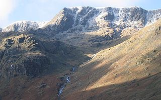
High Crag is a minor fell on the Helvellyn Range in the eastern region of the English Lake District. It sits on the ridge to the south of Helvellyn and Nethermost Pike. It rises sharply above the head of Ruthwaite Cove, and has attracted the attention of rock climbers. Its rock type is a lapilli-tuff of the Helvellyn Tuff Formation.

References

  1. 1 2 Richards, Mark: Near Eastern Fells: Collins (2003): ISBN   0-00-711366-8
  2. Birkett, Bill: Complete Lakeland Fells: Collins Willow (1994): ISBN   0-00-218406-0
  3. A. Harry Griffin. The Guardian, Country Diary . (4 July 1994).
  4. 1 2 Alfred Wainwright: A Pictorial Guide to the Lakeland Fells , Book 1: ISBN   0-7112-2454-4
  5. 1 2 Adams, John: Mines of the Lake District Fells, Dalesman (1995); ISBN   0-85206-931-6
  6. Blair, Don: Exploring Lakeland Tarns: Lakeland Manor Press (2003): ISBN   0-9543904-1-5
  7. Woodhall, DG: Geology of the Keswick District- a brief explanation of the geological map. 1:50,000 Sheet 29: British Geological Survey (2000)