White Side

Last updated

White Side
White Side and Skiddaw.jpg
White Side is the green hill in the foreground.
By Ann Bowker.
Highest point
Elevation 863 m (2,831 ft)
Prominence 42 m (138 ft)
Parent peak Raise
Listing Hewitt, Wainwright, Nuttall
Coordinates 54°32′25″N3°01′35″W / 54.5403°N 3.02626°W / 54.5403; -3.02626
Geography
Lake District National Park UK relief location map.png
Red triangle with thick white border.svg
White Side
Location in Lake District, UK
Location Cumbria, England
Parent range Lake District, Eastern Fells
OS grid NY337166
Topo map OS Landranger 90, Explorer OL5

White Side is a fell in the English Lake District. It is situated to the east of Thirlmere and to the west of Glenridding valley. This places White Side in the Helvellyn range of the Eastern Fells, with Raise to the north and Helvellyn Lower Man to the south, both of which are of greater height.

Contents

Name

Strictly the name White Side refers to the western slope of a nameless summit. However it is often applied to the whole fell for convenience as was done by Alfred Wainwright. [1] He gave White Side the status of a separate fell, a position followed by other guidebook writers. [2] [3] Wainwright suggested that the fell name could have come from the quartz found on the western slope.

Topography

The western and eastern faces of White Side are quite different in appearance. The eastern face is predominantly crag and scree falling abruptly to Keppel and Brown Coves. In contrast the western face falls gently to Thirlmere, the upper parts being mainly grass. The lower parts do provide some rock, such as Brown Crag, but these are generally outcrops rather than true crags.

Map showing White Side and surrounding features from 1925. White Side Map.jpg
Map showing White Side and surrounding features from 1925.

A great steep-sided hollow is gouged out of the eastern face, just north of the summit. This is the corrie of Kepple Cove, backed by Red Screes. Kepple Cove once contained an artificial tarn, although today the bed is merely marshy except after heavy rain. The water from the tarn was used in a hydroelectric scheme to drive electric winding gear at Greenside Mine. Commissioned in 1891, this was the first such system in the country. [4] It continued in use until the night of 29 October 1927 when the Kepple Cove dam burst during a heavy storm, leaving an 80 ft (24 m) wide gap in the earthworks. The resulting wave passed down the valley and through Glenridding village, flooding buildings and causing extensive damage. The breached dam can still be seen today. [4] [5]

South of Kepple Cove, between the southern ridge of White Side and Catstye Cam is Brown Cove. This also held an artificial tarn, but this is now reduced to a couple of small pools widening the stream. Brown Cove Tarn was another creation of the Greenside mine, a stone faced dam being built in about 1860. The dam is still in place but water now leaks through the base, the extended tarn-bed a smooth patch of luxuriant turf. A water leat passing beneath the north face of Catstye Cam to Red Tarn Beck can still be traced although it is now in ruins. There are also the remains of a level driven into the headwall of Brown Cove, a stone arched entrance leading to an 80-yard (73 m) tunnel. [4] [5] Water from Brown and Kepple Coves unites with the outflow of Helvellyn's Red Tarn to form Glenridding Beck, flowing on through the village to Ullswater.

The western slopes of White Side are bounded by Helvellyn and Brund Gills, both of which originally flowed north to the Vale of St John. With the construction of the Thirlmere reservoir scheme in 1884 these streams were diverted to feed the lake a cutting being made through the low ridge which runs parallel to the shore. [1]

Summit

The summit bears a small cairn in a sea of grass with the main ridge path crossing the highest point. Other than north and south where higher fells intervene, the view is good. [1] The subsidiary top of Brown Crag (2,000 feet, 610 m) on the western face also provides fine views of Skiddaw and The Dodds. [2]

Ascents

Ascents from the west begin at Swirls or Thirlspot. The Old Pony or White Stones Routes to Helvellyn can be used to give a start before branching off to White Side. Alternatively a more direct path from behind Fisher Place makes straight for the summit. From Glenridding in the east a bridleway zig-zags up beside Kepple Cove to reach the ridge not far from the top. It is also possible to take a direct (and steep) line direct from Brown Cove Dam. [2]

Related Research Articles

<span class="mw-page-title-main">Helvellyn</span> Mountain in the English Lake District

Helvellyn is a mountain in the English Lake District, the highest point of the Helvellyn range, a north–south line of mountains to the north of Ambleside, between the lakes of Thirlmere and Ullswater.

<span class="mw-page-title-main">Fairfield (Lake District)</span> Fell in the English Lake District

Fairfield is a fell in the English Lake District. It is the highest of a group of hills in the Eastern Fells, standing to the south of the Helvellyn range.

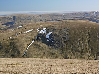
Catstye Cam is a fell in the English Lake District. It is an outlier of Helvellyn in the Eastern Fells.

<span class="mw-page-title-main">Nethermost Pike</span> Fell in Cumbria, England

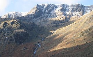
Nethermost Pike is a fell in Cumbria, England, and a part of the Lake District. At 891 metres (2,923 ft) it is the second highest Wainwright in the Helvellyn range, the highest of which is Helvellyn itself. It is located close to the southern end of the ridge, with Helvellyn to the north, and High Crag and Dollywaggon Pike to the south. Nethermost Pike, along with many of the Eastern Fells, lies between Thirlmere in the west and the Ullswater catchment in the east. The closest villages are Glenridding and Patterdale on the shores of Ullswater, over 8 kilometres (5 mi) away.

<span class="mw-page-title-main">Raise (Lake District)</span> Fell in the Lake District, Cumbria, England

Raise is a fell in the English Lake District. It stands on the main spine of the Helvellyn range in the Eastern Fells, between Thirlmere and Ullswater.

<span class="mw-page-title-main">Dollywaggon Pike</span> Mountain in the English Lake District, Cumbria, England

Dollywaggon Pike is a fell in the English Lake District. It stands on the main spine of the Helvellyn range in the Eastern Fells, between Thirlmere and the Ullswater catchment.

<span class="mw-page-title-main">Stybarrow Dodd</span> Fell in the Lake District, Cumbria, England

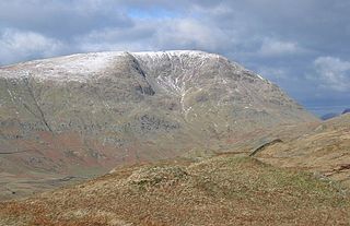
Stybarrow Dodd is a mountain or fell in the English Lake District. It stands immediately north of Sticks Pass on the main ridge of the Helvellyn range in the Eastern Fells, which is situated between the lakes of Thirlmere and the Ullswater.

<span class="mw-page-title-main">Clough Head</span> Mountain in the English Lake District, Cumbria, England

Clough Head is a fell, or hill, in the English Lake District. It marks the northern end of the main ridge of the Helvellyn range and is often walked as part of the ridge walk. The fell stands south of the village of Threlkeld and the A66 road, and it forms the steep eastern side of the tranquil valley of St John's in the Vale.

<span class="mw-page-title-main">Red Screes</span> Mountain in the English Lake District, Cumbria, England

Red Screes is a fell in the English Lake District, situated between the villages of Patterdale and Ambleside. It may be considered an outlier of the Fairfield group in the Eastern Fells, but is separated from its neighbours by low cols. This gives Red Screes an independence which is reflected in its prominence.

High Rigg is a small fell located in the English Lake District, approximately three miles southeast of the town of Keswick. It occupies an unusual position, surrounded on all sides by higher fells but not connected by any obvious ridge. This separation from its fellows ensures that it is a Marilyn.

<span class="mw-page-title-main">Mellbreak</span>

Mellbreak is a hill in the Western part of the English Lake District. Despite being surrounded on all sides by higher fells, it stands in isolation. It is surrounded on three sides by a "moat" of deep marshy land, and on the east side by the lake of Crummock Water. The fell forms a partnership with the lake, running parallel to it, falling sheer into it, and regularly providing the backdrop for pictures of it.

<span class="mw-page-title-main">Red Tarn</span> A mountain lake in Cumbria, England

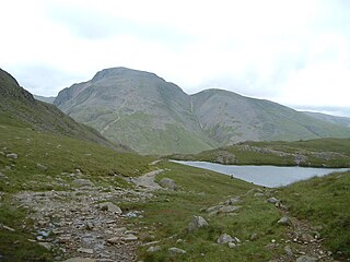
Red Tarn is a small lake in the eastern region of the English Lake District, in the county of Cumbria. It is high up on the eastern flank of Helvellyn, beneath Striding Edge and Catstye Cam. Red Tarn was formed when the glacier that carved out the eastern side of Helvellyn had melted. The lake along with three others in Lake District is a habitat for the very rare and endangered Schelly fish. Red Tarn was a dam in the nineteenth century that used boulders that raised the water level some eight or nine feet in order to supply power to the Greenside Mine at Glenridding. Today the tarn is a popular rest stop for hikers and nature goers.

<span class="mw-page-title-main">Dow Crag</span> Fell in the Lake District, Cumbria, England

Dow Crag is a fell in the English Lake District near Coniston, Cumbria. The eastern face is one of the many rock faces in the Lake District used for rock climbing.

<span class="mw-page-title-main">Green Gable</span>

Green Gable is a fell in the English Lake District often traversed by walkers en route to its more famous neighbour Great Gable. It can be ascended from Honister Pass, Seathwaite in Borrowdale, or Ennerdale. There are good views of Gable Crag, Scafell Pike and the Buttermere valley from the summit.

<span class="mw-page-title-main">Ullscarf</span> Fell in England

Ullscarf is a fell in the English Lake District close to the geographical centre of the Cumbrian hills. It forms part of the watershed between the Derwentwater and Thirlmere catchments, a ridge running broadly north-south.

Armboth Fell is a fell in the English Lake District, regarded by Alfred Wainwright as the centre of Lakeland. It is named for the former settlement of Armboth. The fell is a domed plateau, three-quarters of a mile across, jutting out to the east of the Derwentwater-Thirlmere watershed, in the Borough of Allerdale. The fell is wet underfoot, with large areas clad in heather. The eastern slopes above Thirlmere have been planted with conifers.

<span class="mw-page-title-main">Hart Side</span>

Hart Side is a subsidiary top on one of the east ridges of Stybarrow Dodd, which is a mountain in the English Lake District, west of Ullswater on the main Helvellyn ridge in the Eastern Fells. With a height of 2,480 feet (760 m) Hart Side rises above the col separating it from Green Side by 75 feet (23 m).

<span class="mw-page-title-main">Birkhouse Moor</span>

Birkhouse Moor is a fell in the English Lake District, an outlier of the Helvellyn range in the Eastern Fells. It is properly an eastern ridge of Helvellyn, but was treated as a separate fell by Alfred Wainwright in his Pictorial Guide to the Lakeland Fells. That convention is followed here.

<span class="mw-page-title-main">Sheffield Pike</span>

Sheffield Pike is a fell in the English Lake District, a prominent intermediate top on one of the eastern ridges of Stybarrow Dodd. It separates and stands high above the Glencoyne and Glenridding valleys, on the eastern side of the Helvellyn range in the Eastern Fells and it looks down onto Ullswater.

<span class="mw-page-title-main">Eastern Fells</span>

The Eastern Fells are a group of hills in the English Lake District. Centred on Helvellyn they primarily comprise a north–south ridge running between Ullswater and Lakeland's Central Valley.

References

  1. 1 2 3 Alfred Wainwright: A Pictorial Guide to the Lakeland Fells , Book 1: ISBN   0-7112-2454-4
  2. 1 2 3 Richards, Mark; Near Eastern Fells; Collins (2003); ISBN   0-00-711366-8
  3. Birkett, Bill: Complete Lakeland Fells: Collins Willow (1994): ISBN   0-00-218406-0
  4. 1 2 3 Adams, John: Mines of the Lake District Fells, Dalesman (1995); ISBN   0-85206-931-6
  5. 1 2 Blair, Don; Exploring Lakeland Tarns; Lakeland Manor Press (2003); ISBN   0-9543904-1-5